Mount Mitchell Topo Map Oregon
To zoom in, hover over the map of Mount Mitchell
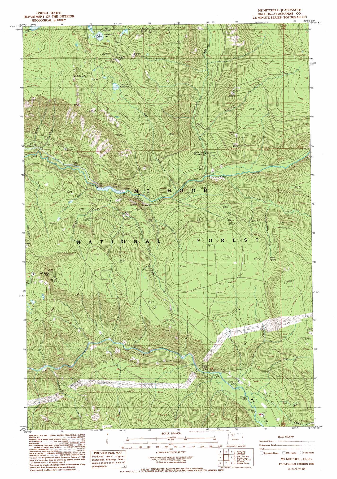
USGS Topo Quad 45121a8 - 1:24,000 scale
| Topo Map Name: | Mount Mitchell |
| USGS Topo Quad ID: | 45121a8 |
| Print Size: | ca. 21 1/4" wide x 27" high |
| Southeast Coordinates: | 45° N latitude / 121.875° W longitude |
| Map Center Coordinates: | 45.0625° N latitude / 121.9375° W longitude |
| U.S. State: | OR |
| Filename: | o45121a8.jpg |
| Download Map JPG Image: | Mount Mitchell topo map 1:24,000 scale |
| Map Type: | Topographic |
| Topo Series: | 7.5´ |
| Map Scale: | 1:24,000 |
| Source of Map Images: | United States Geological Survey (USGS) |
| Alternate Map Versions: |
Mt. Mitchell OR 1985, updated 1985 Download PDF Buy paper map Mount Mitchell OR 1997, updated 1999 Download PDF Buy paper map Mount Mitchell OR 2011 Download PDF Buy paper map Mount Mitchell OR 2014 Download PDF Buy paper map |
| FStopo: | US Forest Service topo Mount Mitchell is available: Download FStopo PDF Download FStopo TIF |
1:24,000 Topo Quads surrounding Mount Mitchell
Cherryville |
Salmon |
Rhododendron |
Government Camp |
Mount Hood South |
Bedford Point |
Three Lynx |
High Rock |
Wolf Peak |
Wapinitia Pass |
Wanderers Peak |
Fish Creek Mountain |
Mount Mitchell |
Timothy Lake |
Mount Wilson |
Bagby Hot Spring |
Bull Of The Woods |
Mount Lowe |
Pinhead Buttes |
Fort Butte |
Battle Ax |
Mother Lode Mountain |
Breitenbush Hot Spring |
Olallie Butte |
Boulder Lake |
> Back to 45121a1 at 1:100,000 scale
> Back to 45120a1 at 1:250,000 scale
> Back to U.S. Topo Maps home
Mount Mitchell topo map: Gazetteer
Mount Mitchell: Bends
Big Bottom elevation 638m 2093′Mount Mitchell: Dams
Lake Harriet Dam elevation 621m 2037′Mount Mitchell: Flats
Cottonwood Meadows elevation 1229m 4032′Mount Mitchell: Lakes
Hideaway Lake elevation 1248m 4094′Mount Mitchell: Reservoirs
Lake Harriet elevation 621m 2037′Mount Mitchell: Springs
Devils Spring elevation 967m 3172′Steep Spring elevation 851m 2791′
Mount Mitchell: Streams
Cabin Creek elevation 633m 2076′Canyon Creek elevation 599m 1965′
Cot Creek elevation 663m 2175′
Devils Spring Creek elevation 762m 2500′
Granite Creek elevation 524m 1719′
Kelley Creek elevation 630m 2066′
Kink Creek elevation 687m 2253′
Lightning Creek elevation 741m 2431′
Lost Creek elevation 637m 2089′
Pan Creek elevation 636m 2086′
Peavine Creek elevation 684m 2244′
Pot Creek elevation 628m 2060′
Sam Creek elevation 593m 1945′
Shellrock Creek elevation 671m 2201′
Skunk Creek elevation 602m 1975′
Spring Creek elevation 635m 2083′
Wolf Creek elevation 645m 2116′
Mount Mitchell: Summits
Mount Mitchell elevation 1450m 4757′Oak Grove Butte elevation 1405m 4609′
Mount Mitchell: Trails
Buck Lake Trail elevation 1428m 4685′Cottonwood Meadows Trail elevation 1359m 4458′
Pot Creek Trail elevation 842m 2762′
Mount Mitchell digital topo map on disk
Buy this Mount Mitchell topo map showing relief, roads, GPS coordinates and other geographical features, as a high-resolution digital map file on DVD: