Maupin Topo Map Oregon
To zoom in, hover over the map of Maupin
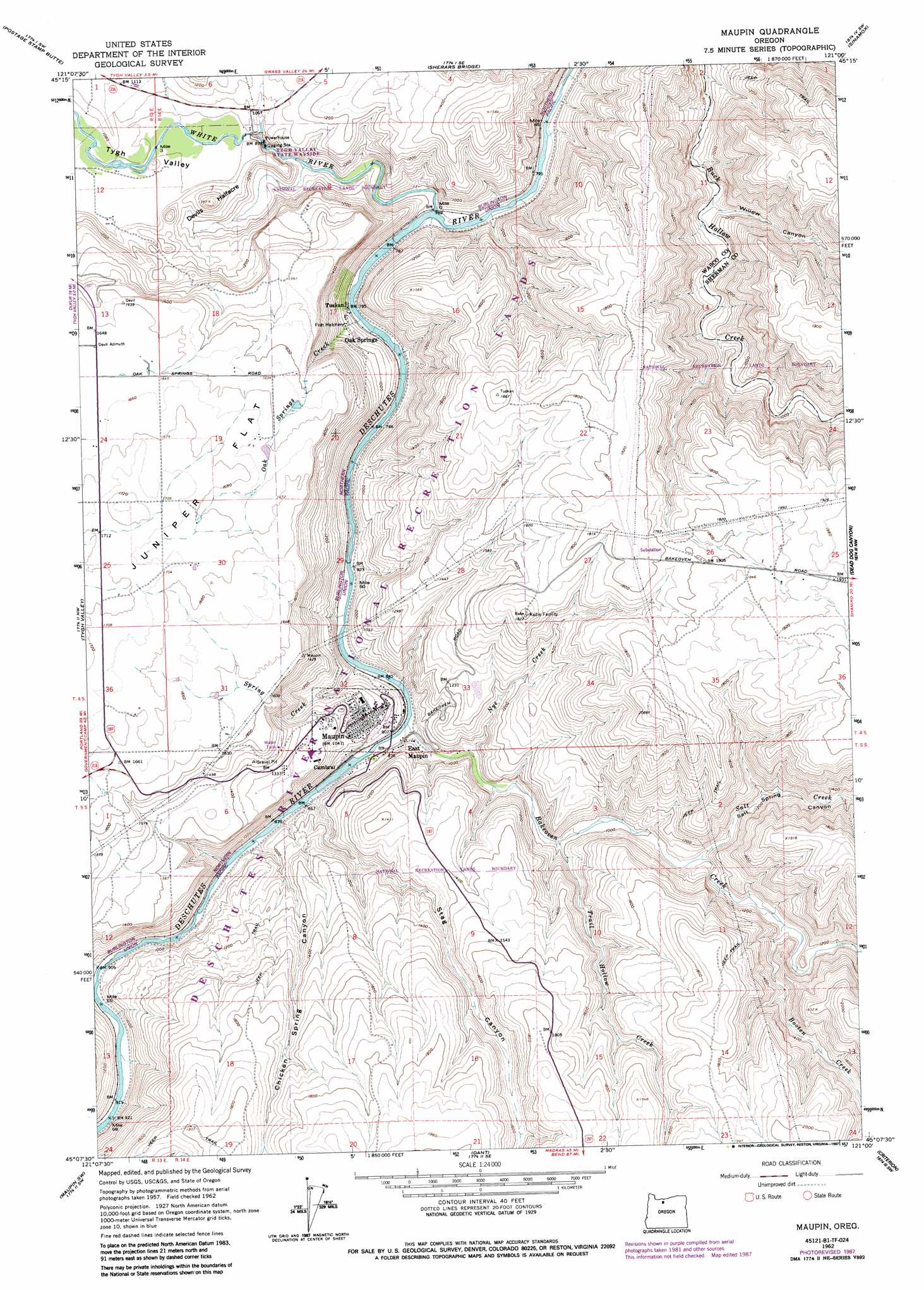
USGS Topo Quad 45121b1 - 1:24,000 scale
| Topo Map Name: | Maupin |
| USGS Topo Quad ID: | 45121b1 |
| Print Size: | ca. 21 1/4" wide x 27" high |
| Southeast Coordinates: | 45.125° N latitude / 121° W longitude |
| Map Center Coordinates: | 45.1875° N latitude / 121.0625° W longitude |
| U.S. State: | OR |
| Filename: | o45121b1.jpg |
| Download Map JPG Image: | Maupin topo map 1:24,000 scale |
| Map Type: | Topographic |
| Topo Series: | 7.5´ |
| Map Scale: | 1:24,000 |
| Source of Map Images: | United States Geological Survey (USGS) |
| Alternate Map Versions: |
Maupin OR 1962, updated 1964 Download PDF Buy paper map Maupin OR 1962, updated 1975 Download PDF Buy paper map Maupin OR 1962, updated 1987 Download PDF Buy paper map Maupin OR 1996, updated 1998 Download PDF Buy paper map Maupin OR 2011 Download PDF Buy paper map Maupin OR 2014 Download PDF Buy paper map |
| FStopo: | US Forest Service topo Maupin is available: Download FStopo PDF Download FStopo TIF |
1:24,000 Topo Quads surrounding Maupin
Wolf Run |
Dufur West |
Dufur East |
Summit Ridge |
Erskine |
Friend |
Postage Stamp Butte |
Sherars Bridge |
Sinamox |
Grass Valley |
Wamic |
Tygh Valley |
Maupin |
Dead Dog Canyon |
Bronx Canyon |
Wapinitia |
Maupin Sw |
Dant |
Criterion |
Shaniko |
Simnasho |
Mutton Mountain |
Kaskela |
Shaniko Junction |
Shaniko Summit |
> Back to 45121a1 at 1:100,000 scale
> Back to 45120a1 at 1:250,000 scale
> Back to U.S. Topo Maps home
Maupin topo map: Gazetteer
Maupin: Parks
White River Falls State Park elevation 286m 938′Maupin: Populated Places
East Maupin elevation 261m 856′Maupin elevation 324m 1062′
Maupin: Post Offices
Maupin Post Office elevation 324m 1062′Maupin: Streams
Bakeoven Creek elevation 253m 830′Booten Creek elevation 333m 1092′
Nye Creek elevation 269m 882′
Oak Springs Creek elevation 239m 784′
Salt Creek elevation 315m 1033′
Spring Creek elevation 257m 843′
Trail Hollow Creek elevation 292m 958′
White River elevation 233m 764′
Maupin: Summits
Devils Halfacre elevation 416m 1364′Maupin: Valleys
Chicken Spring Canyon elevation 271m 889′Salt Springs Canyon elevation 320m 1049′
Stag Canyon elevation 257m 843′
Tygh Valley elevation 306m 1003′
Willow Canyon elevation 257m 843′
Maupin digital topo map on disk
Buy this Maupin topo map showing relief, roads, GPS coordinates and other geographical features, as a high-resolution digital map file on DVD: