Postage Stamp Butte Topo Map Oregon
To zoom in, hover over the map of Postage Stamp Butte
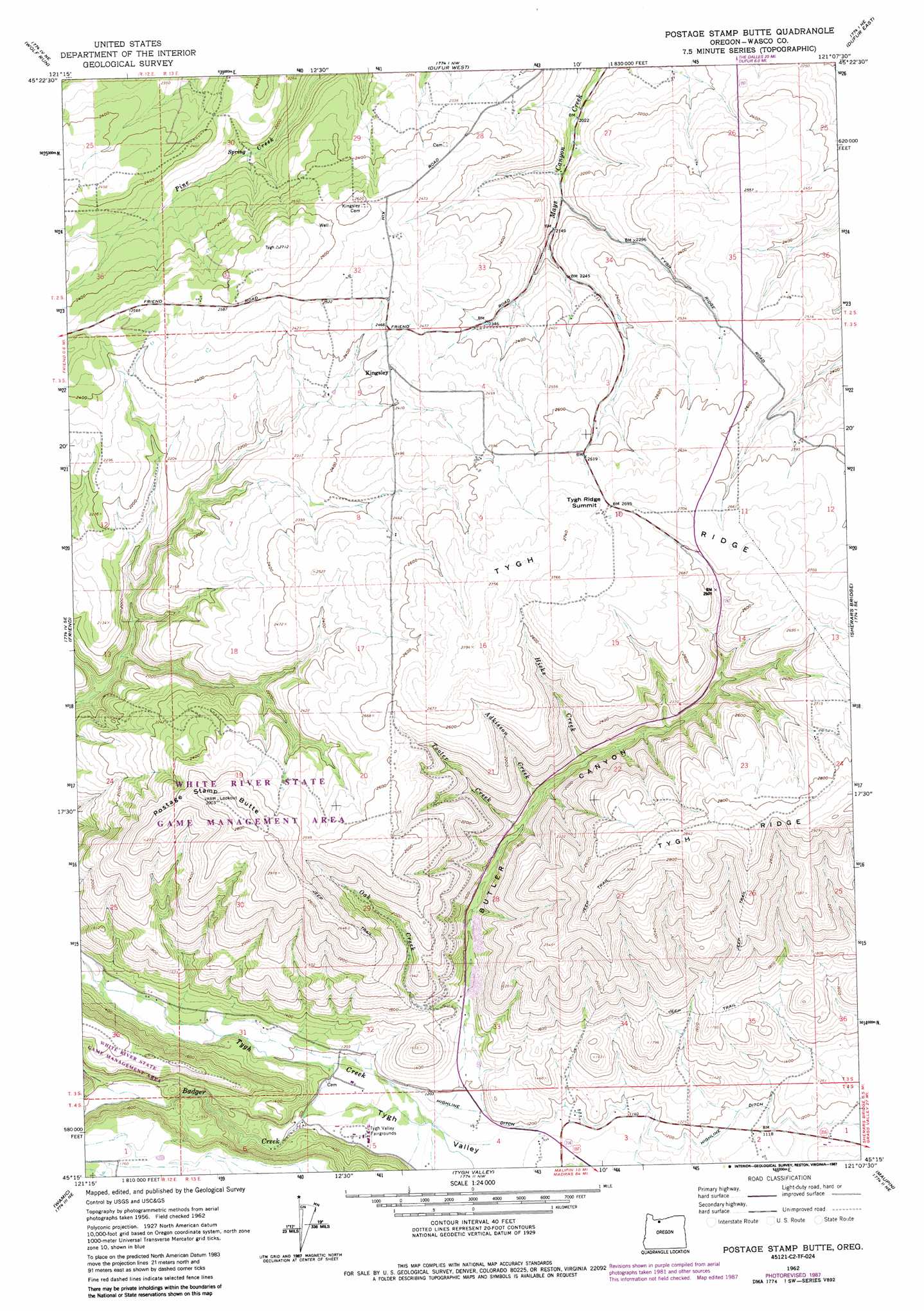
USGS Topo Quad 45121c2 - 1:24,000 scale
| Topo Map Name: | Postage Stamp Butte |
| USGS Topo Quad ID: | 45121c2 |
| Print Size: | ca. 21 1/4" wide x 27" high |
| Southeast Coordinates: | 45.25° N latitude / 121.125° W longitude |
| Map Center Coordinates: | 45.3125° N latitude / 121.1875° W longitude |
| U.S. State: | OR |
| Filename: | o45121c2.jpg |
| Download Map JPG Image: | Postage Stamp Butte topo map 1:24,000 scale |
| Map Type: | Topographic |
| Topo Series: | 7.5´ |
| Map Scale: | 1:24,000 |
| Source of Map Images: | United States Geological Survey (USGS) |
| Alternate Map Versions: |
Postage Stamp Butte OR 1962, updated 1964 Download PDF Buy paper map Postage Stamp Butte OR 1962, updated 1983 Download PDF Buy paper map Postage Stamp Butte OR 1962, updated 1987 Download PDF Buy paper map Postage Stamp Butte OR 2011 Download PDF Buy paper map Postage Stamp Butte OR 2014 Download PDF Buy paper map |
1:24,000 Topo Quads surrounding Postage Stamp Butte
Ketchum Reservoir |
Brown Creek |
The Dalles South |
Petersburg |
Emerson |
Fivemile Butte |
Wolf Run |
Dufur West |
Dufur East |
Summit Ridge |
Flag Point |
Friend |
Postage Stamp Butte |
Sherars Bridge |
Sinamox |
Rock Creek Reservoir |
Wamic |
Tygh Valley |
Maupin |
Dead Dog Canyon |
Foreman Point |
Wapinitia |
Maupin Sw |
Dant |
Criterion |
> Back to 45121a1 at 1:100,000 scale
> Back to 45120a1 at 1:250,000 scale
> Back to U.S. Topo Maps home
Postage Stamp Butte topo map: Gazetteer
Postage Stamp Butte: Canals
Highline Ditch elevation 354m 1161′Postage Stamp Butte: Gaps
Tygh Ridge Summit elevation 826m 2709′Postage Stamp Butte: Lakes
Smith Ponds elevation 754m 2473′Postage Stamp Butte: Populated Places
Kingsley elevation 745m 2444′Postage Stamp Butte: Post Offices
Kingsley Post Office (historical) elevation 745m 2444′Postage Stamp Butte: Reservoirs
Hendricks Reservoirs elevation 827m 2713′Postage Stamp Butte: Streams
Adkisson Creek elevation 513m 1683′Badger Creek elevation 347m 1138′
Hicks Creek elevation 545m 1788′
Oak Creek elevation 396m 1299′
Tooter Creek elevation 491m 1610′
Postage Stamp Butte: Summits
Postage Stamp Butte elevation 882m 2893′Postage Stamp Butte: Valleys
Butler Canyon elevation 367m 1204′Postage Stamp Butte digital topo map on disk
Buy this Postage Stamp Butte topo map showing relief, roads, GPS coordinates and other geographical features, as a high-resolution digital map file on DVD: