Mount Hood North Topo Map Oregon
To zoom in, hover over the map of Mount Hood North
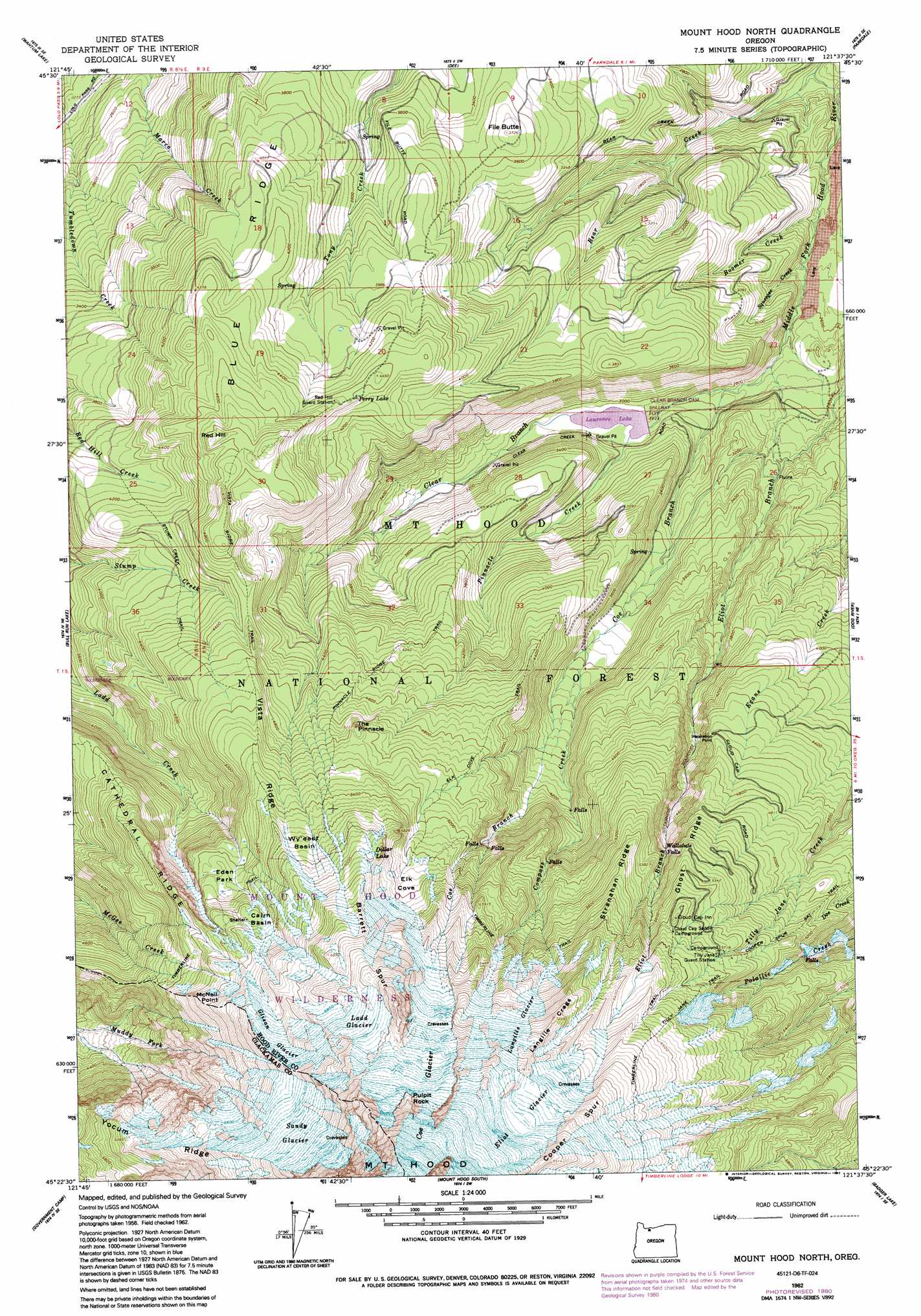
USGS Topo Quad 45121d6 - 1:24,000 scale
| Topo Map Name: | Mount Hood North |
| USGS Topo Quad ID: | 45121d6 |
| Print Size: | ca. 21 1/4" wide x 27" high |
| Southeast Coordinates: | 45.375° N latitude / 121.625° W longitude |
| Map Center Coordinates: | 45.4375° N latitude / 121.6875° W longitude |
| U.S. State: | OR |
| Filename: | o45121d6.jpg |
| Download Map JPG Image: | Mount Hood North topo map 1:24,000 scale |
| Map Type: | Topographic |
| Topo Series: | 7.5´ |
| Map Scale: | 1:24,000 |
| Source of Map Images: | United States Geological Survey (USGS) |
| Alternate Map Versions: |
Cathedral Ridge OR 1962, updated 1964 Download PDF Buy paper map Cathedral Ridge OR 1962, updated 1970 Download PDF Buy paper map Mount Hood North OR 1962, updated 1979 Download PDF Buy paper map Mount Hood North OR 1962, updated 1980 Download PDF Buy paper map Mount Hood North OR 1962, updated 1992 Download PDF Buy paper map Mount Hood North OR 1996, updated 1998 Download PDF Buy paper map Mount Hood North OR 2011 Download PDF Buy paper map Mount Hood North OR 2014 Download PDF Buy paper map |
| FStopo: | US Forest Service topo Mount Hood North is available: Download FStopo PDF Download FStopo TIF |
1:24,000 Topo Quads surrounding Mount Hood North
Bonneville Dam |
Carson |
Mount Defiance |
Hood River |
White Salmon |
Tanner Butte |
Wahtum Lake |
Dee |
Parkdale |
Ketchum Reservoir |
Hickman Butte |
Bull Run Lake |
Mount Hood North |
Dog River |
Fivemile Butte |
Rhododendron |
Government Camp |
Mount Hood South |
Badger Lake |
Flag Point |
High Rock |
Wolf Peak |
Wapinitia Pass |
Post Point |
Rock Creek Reservoir |
> Back to 45121a1 at 1:100,000 scale
> Back to 45120a1 at 1:250,000 scale
> Back to U.S. Topo Maps home
Mount Hood North topo map: Gazetteer
Mount Hood North: Areas
Cloud Cap-Tilly Jane Historic Area elevation 1529m 5016′Mount Hood North: Basins
Cairn Basin elevation 1725m 5659′Eden Park elevation 1606m 5269′
Elk Cove elevation 1671m 5482′
Wy'east Basin elevation 1731m 5679′
Mount Hood North: Cliffs
Pulpit Rock elevation 2665m 8743′Sandy Glacier Headwall elevation 2735m 8973′
Mount Hood North: Dams
Clear Branch Dam elevation 874m 2867′Mount Hood North: Falls
Wallalute Falls elevation 1499m 4917′Mount Hood North: Glaciers
Coe Glacier elevation 2548m 8359′Eliot Glacier elevation 2397m 7864′
Glisan Glacier elevation 2029m 6656′
Ladd Glacier elevation 2192m 7191′
Langille Glacier elevation 2105m 6906′
Sandy Glacier elevation 2330m 7644′
Mount Hood North: Lakes
Dollar Lake elevation 1823m 5980′Perry Lake elevation 1341m 4399′
Recession Lakes elevation 2179m 7148′
Mount Hood North: Pillars
The Pinnacle elevation 1565m 5134′Mount Hood North: Reservoirs
Laurance Lake elevation 874m 2867′Mount Hood North: Ridges
Barrett Spur elevation 2120m 6955′Cathedral Ridge elevation 1635m 5364′
Cooper Spur elevation 2394m 7854′
Ghost Ridge elevation 1679m 5508′
Inspiration Point elevation 1394m 4573′
Langille Crags elevation 2197m 7208′
McNeil Point elevation 1825m 5987′
Stranahan Ridge elevation 1714m 5623′
Vista Ridge elevation 1584m 5196′
Yocum Ridge elevation 1934m 6345′
Mount Hood North: Streams
Bear Creek elevation 620m 2034′Boomer Creek elevation 712m 2335′
Clear Branch elevation 805m 2641′
Coe Branch elevation 830m 2723′
Compass Creek elevation 1086m 3562′
Eliot Branch elevation 805m 2641′
Pinnacle Creek elevation 866m 2841′
Squeegee Creek elevation 745m 2444′
Mount Hood North: Summits
File Butte elevation 1133m 3717′Red Hill elevation 1500m 4921′
Mount Hood North: Trails
Cooper Spur Ski Trail elevation 1560m 5118′Elk Grove Trail elevation 1426m 4678′
Pinnacle Ridge Trail elevation 1291m 4235′
Stump Creek Trail elevation 1277m 4189′
Tilly Jane Trail elevation 1914m 6279′
Timberline Trail elevation 1750m 5741′
Vista Ridge Trail elevation 1411m 4629′
Mount Hood North digital topo map on disk
Buy this Mount Hood North topo map showing relief, roads, GPS coordinates and other geographical features, as a high-resolution digital map file on DVD: