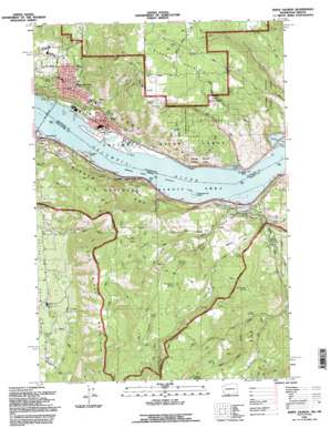
White Salmon Topo Map Oregon
To zoom in, hover over the map of White Salmon
USGS Topo Quad 45121f4 - 1:24,000 scale
| Topo Map Name: | White Salmon |
| USGS Topo Quad ID: | 45121f4 |
| Print Size: | ca. 21 1/4" wide x 27" high |
| Southeast Coordinates: | 45.625° N latitude / 121.375° W longitude |
| Map Center Coordinates: | 45.6875° N latitude / 121.4375° W longitude |
| U.S. States: | OR, WA |
| Filename: | o45121f4.jpg |
| Download Map JPG Image: | White Salmon topo map 1:24,000 scale |
| Map Type: | Topographic |
| Topo Series: | 7.5´ |
| Map Scale: | 1:24,000 |
| Source of Map Images: | United States Geological Survey (USGS) |
| Alternate Map Versions: |
White Salmon WA 1975, updated 1980 Download PDF Buy paper map White Salmon WA 1978, updated 1978 Download PDF Buy paper map White Salmon WA 1994, updated 1996 Download PDF Buy paper map White Salmon WA 2011 Download PDF Buy paper map White Salmon WA 2014 Download PDF Buy paper map |
| FStopo: | US Forest Service topo White Salmon is available: Download FStopo PDF Download FStopo TIF |
1:24,000 Topo Quads surrounding White Salmon
> Back to 45121e1 at 1:100,000 scale
> Back to 45120a1 at 1:250,000 scale
> Back to U.S. Topo Maps home
White Salmon topo map: Gazetteer
White Salmon: Beaches
Koberg Beach elevation 25m 82′White Salmon: Channels
Bingen Range Channel elevation 24m 78′White Salmon: Flats
Huskey Flat elevation 305m 1000′Rocky Prairie elevation 204m 669′
White Salmon: Gaps
Bingen Gap elevation 24m 78′Bingen Gap elevation 83m 272′
White Salmon: Islands
Eighteenmile Island elevation 40m 131′Eighteenmile Island elevation 33m 108′
White Salmon: Lakes
Indian Lake elevation 351m 1151′Koberg Slough elevation 31m 101′
Look Lake elevation 25m 82′
Rowland Lake elevation 24m 78′
White Salmon: Parks
Historic Columbia River Highway State Trail elevation 108m 354′Jewett Creek Park elevation 156m 511′
Koberg Beach State Park elevation 37m 121′
Pioneer Park elevation 180m 590′
White Salmon: Pillars
Stanley Rock elevation 74m 242′White Salmon: Populated Places
Bingen elevation 39m 127′Mosier elevation 38m 124′
Straight Point elevation 28m 91′
White Salmon elevation 189m 620′
White Salmon: Post Offices
Mosier Post Office elevation 38m 124′White Salmon: Springs
Bachelor Spring elevation 229m 751′Burlingame Spring elevation 272m 892′
Guttery Spring elevation 218m 715′
Johnson Spring elevation 139m 456′
Lelliot Spring elevation 243m 797′
Mosier Springs elevation 82m 269′
Pond Spring elevation 179m 587′
Sanford Spring elevation 255m 836′
Tanawasher Spring elevation 339m 1112′
White Salmon: Streams
Campbell Creek elevation 93m 305′Dry Creek elevation 85m 278′
Dry Creek elevation 61m 200′
Jewett Creek elevation 27m 88′
Mosier Creek elevation 24m 78′
Rock Creek elevation 24m 78′
West Fork Mosier Creek elevation 164m 538′
White Salmon: Summits
Burdoin Mountain elevation 672m 2204′Hood River Mountain elevation 729m 2391′
Panorama Point elevation 211m 692′
Tracy Hill elevation 625m 2050′
White Salmon: Valleys
Snyder Canyon elevation 355m 1164′White Salmon digital topo map on disk
Buy this White Salmon topo map showing relief, roads, GPS coordinates and other geographical features, as a high-resolution digital map file on DVD:


