Hood River Topo Map Oregon
To zoom in, hover over the map of Hood River
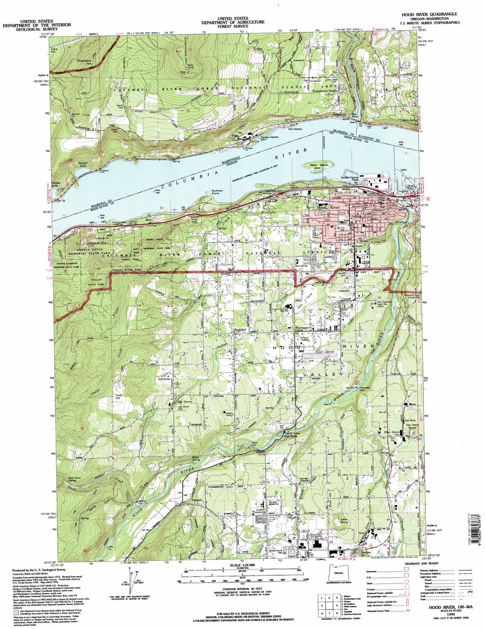
USGS Topo Quad 45121f5 - 1:24,000 scale
| Topo Map Name: | Hood River |
| USGS Topo Quad ID: | 45121f5 |
| Print Size: | ca. 21 1/4" wide x 27" high |
| Southeast Coordinates: | 45.625° N latitude / 121.5° W longitude |
| Map Center Coordinates: | 45.6875° N latitude / 121.5625° W longitude |
| U.S. States: | OR, WA |
| Filename: | o45121f5.jpg |
| Download Map JPG Image: | Hood River topo map 1:24,000 scale |
| Map Type: | Topographic |
| Topo Series: | 7.5´ |
| Map Scale: | 1:24,000 |
| Source of Map Images: | United States Geological Survey (USGS) |
| Alternate Map Versions: |
Hood River NE OR 1975, updated 1980 Download PDF Buy paper map Hood River OR 1979, updated 1980 Download PDF Buy paper map Hood River OR 1994, updated 1996 Download PDF Buy paper map Hood River OR 2011 Download PDF Buy paper map Hood River OR 2014 Download PDF Buy paper map |
| FStopo: | US Forest Service topo Hood River is available: Download FStopo PDF Download FStopo TIF |
1:24,000 Topo Quads surrounding Hood River
Gifford Peak |
Little Huckleberry Mountain |
Guler Mountain |
Quigley Butte |
Camas Prairie |
Big Huckleberry Mountain |
Willard |
Northwestern Lake |
Husum |
Appleton |
Carson |
Mount Defiance |
Hood River |
White Salmon |
Lyle |
Wahtum Lake |
Dee |
Parkdale |
Ketchum Reservoir |
Brown Creek |
Bull Run Lake |
Mount Hood North |
Dog River |
Fivemile Butte |
Wolf Run |
> Back to 45121e1 at 1:100,000 scale
> Back to 45120a1 at 1:250,000 scale
> Back to U.S. Topo Maps home
Hood River topo map: Gazetteer
Hood River: Airports
Green Acres Air Park elevation 245m 803′Hood River Airport elevation 187m 613′
United Telephone System Airstrip elevation 59m 193′
Hood River: Bays
Ruthton Cove elevation 24m 78′Hood River: Bridges
Tucker Bridge elevation 132m 433′Hood River: Canals
Farmers Ditch elevation 257m 843′Power Canal elevation 64m 209′
Hood River: Capes
Mitchell Point elevation 192m 629′Ruthton Point elevation 24m 78′
Hood River: Dams
Powerdale Dam elevation 86m 282′Hood River: Falls
Wah Gwin Gwin Falls elevation 68m 223′Hood River: Harbors
Waucoma Basin elevation 24m 78′Hood River: Islands
Wells Island elevation 29m 95′Hood River: Parks
Coe Park elevation 127m 416′Eliot Park elevation 117m 383′
Jackson Park elevation 134m 439′
Mann Park elevation 126m 413′
Morrison Park elevation 63m 206′
Oak Grove County Park elevation 310m 1017′
Panorama Point County Park elevation 187m 613′
Port Marina Park elevation 27m 88′
Ruthton County Park elevation 113m 370′
Seneca Fouts Memorial State Park elevation 24m 78′
Tucker County Park elevation 149m 488′
Waucoma Park elevation 89m 291′
Wilson Park elevation 127m 416′
Winans Park elevation 54m 177′
Hood River: Populated Places
Ericson View Tracts elevation 387m 1269′Hood elevation 38m 124′
Hood River elevation 126m 413′
Hood View Tracts elevation 364m 1194′
Lenz elevation 223m 731′
Oak Grove elevation 308m 1010′
Odell elevation 220m 721′
Pine Grove elevation 199m 652′
Rockford elevation 199m 652′
Underwood elevation 36m 118′
Underwood Heights elevation 134m 439′
Hood River: Post Offices
Hood River Post Office elevation 126m 413′Menominee Post Office (historical) elevation 33m 108′
Odell Post Office elevation 220m 721′
Tucker Post Office (historical) elevation 149m 488′
Hood River: Reservoirs
Buehler Pond elevation 409m 1341′Duckwall Reservoir elevation 217m 711′
Hood River: Springs
Hakel Spring elevation 172m 564′McGuire Spring elevation 166m 544′
Rhoades Spring elevation 221m 725′
Smith Spring elevation 136m 446′
Hood River: Streams
Alder Brook elevation 243m 797′Cedar Creek elevation 55m 180′
Ditch Creek elevation 489m 1604′
Ferguson Creek elevation 163m 534′
Flume Creek elevation 306m 1003′
Henderson Creek elevation 24m 78′
Hood River elevation 24m 78′
Indian Creek elevation 138m 452′
Lenz Creek elevation 179m 587′
Neal Creek elevation 139m 456′
Odell Creek elevation 122m 400′
Phelps Creek elevation 24m 78′
Rhoades Creek elevation 209m 685′
Shelley Creek elevation 212m 695′
Shelly Creek elevation 183m 600′
Spring Creek elevation 229m 751′
Whiskey Creek elevation 133m 436′
White Salmon River elevation 24m 78′
Hood River: Summits
Chemawa Hill elevation 525m 1722′Davidson Hill elevation 171m 561′
Erk Hill elevation 260m 853′
Lenz Butte elevation 301m 987′
Van Horn Butte elevation 257m 843′
Hood River: Tunnels
Tunnel No. 1 elevation 84m 275′Tunnel No. 2 elevation 82m 269′
Tunnel No. 3 elevation 57m 187′
Tunnel No. 4 elevation 70m 229′
Hood River: Valleys
Hood River Valley elevation 24m 78′Post Canyon elevation 218m 715′
Hood River digital topo map on disk
Buy this Hood River topo map showing relief, roads, GPS coordinates and other geographical features, as a high-resolution digital map file on DVD: