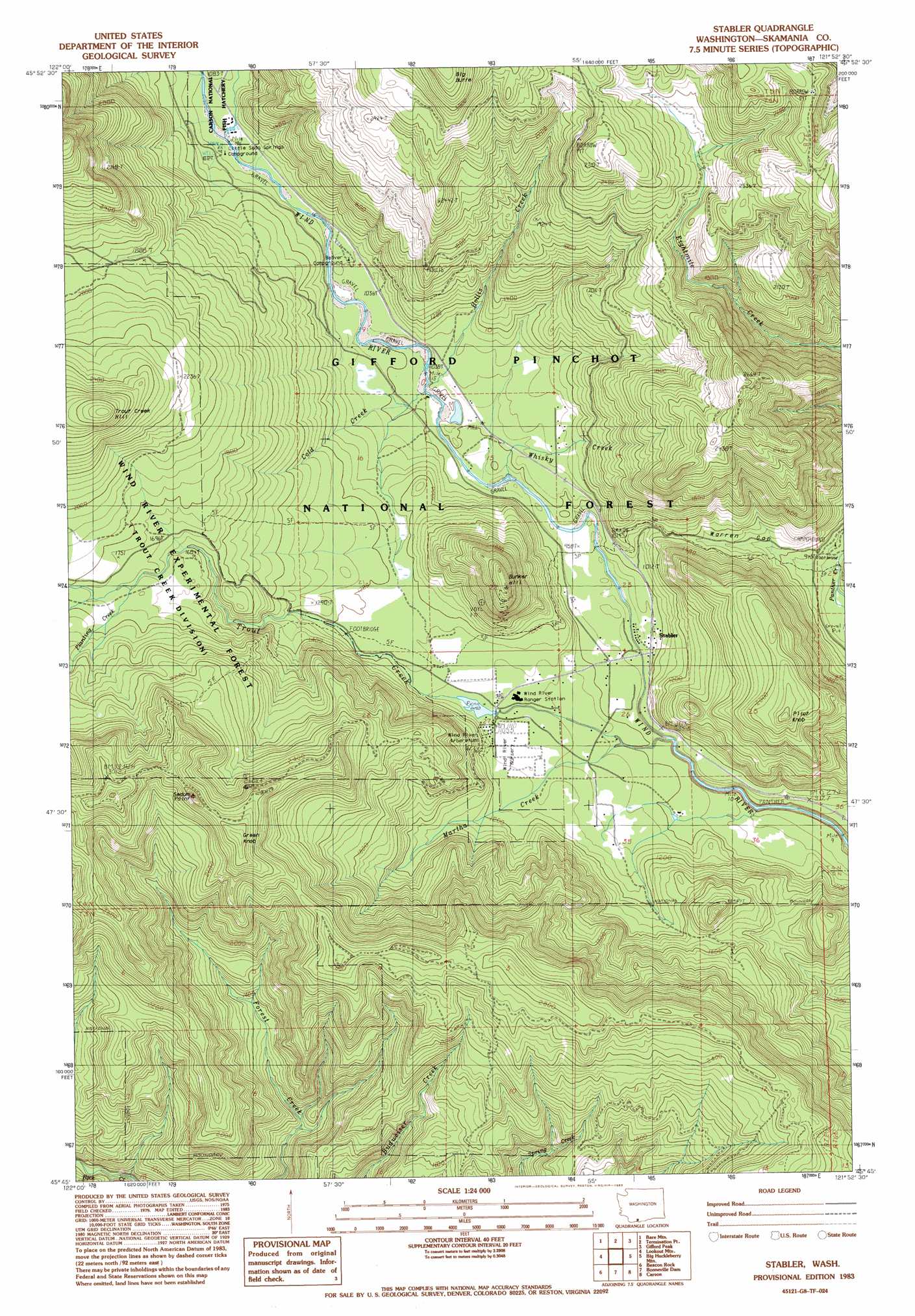
Stabler Topo Map Washington
To zoom in, hover over the map of Stabler
USGS Topo Quad 45121g8 - 1:24,000 scale
| Topo Map Name: | Stabler |
| USGS Topo Quad ID: | 45121g8 |
| Print Size: | ca. 21 1/4" wide x 27" high |
| Southeast Coordinates: | 45.75° N latitude / 121.875° W longitude |
| Map Center Coordinates: | 45.8125° N latitude / 121.9375° W longitude |
| U.S. State: | WA |
| Filename: | o45121g8.jpg |
| Download Map JPG Image: | Stabler topo map 1:24,000 scale |
| Map Type: | Topographic |
| Topo Series: | 7.5´ |
| Map Scale: | 1:24,000 |
| Source of Map Images: | United States Geological Survey (USGS) |
| Alternate Map Versions: |
Stabler WA 1983, updated 1983 Download PDF Buy paper map Stabler WA 1998, updated 2003 Download PDF Buy paper map Stabler WA 2011 Download PDF Buy paper map Stabler WA 2014 Download PDF Buy paper map |
| FStopo: | US Forest Service topo Stabler is available: Download FStopo PDF Download FStopo TIF |
1:24,000 Topo Quads surrounding Stabler
Mount Mitchell |
Cedar Flats |
Burnt Peak |
Lone Butte |
Sleeping Beauty |
Siouxon Peak |
Bare Mountain |
Termination Point |
Gifford Peak |
Little Huckleberry Mountain |
Gumboot Mountain |
Lookout Mountain |
Stabler |
Big Huckleberry Mountain |
Willard |
Bobs Mountain |
Beacon Rock |
Bonneville Dam |
Carson |
Mount Defiance |
Bridal Veil |
Multnomah Falls |
Tanner Butte |
Wahtum Lake |
Dee |
> Back to 45121e1 at 1:100,000 scale
> Back to 45120a1 at 1:250,000 scale
> Back to U.S. Topo Maps home
Stabler topo map: Gazetteer
Stabler: Dams
Hemlock Dam (historical) elevation 338m 1108′Stabler: Forests
Wind River Experimental Forest elevation 634m 2080′Stabler: Gaps
Warren Gap elevation 363m 1190′Stabler: Parks
Wind River Arboretum elevation 348m 1141′Wind River Natural Area elevation 498m 1633′
Stabler: Populated Places
Stabler elevation 290m 951′Stabler: Reservoirs
Trout Creek Pond (historical) elevation 338m 1108′Stabler: Streams
Cold Creek elevation 304m 997′Hollis Creek elevation 307m 1007′
Martha Creek elevation 306m 1003′
Planting Creek elevation 535m 1755′
Trout Creek elevation 262m 859′
Whisky Creek elevation 344m 1128′
Stabler: Summits
Big Butte elevation 1025m 3362′Bunker Hill elevation 671m 2201′
Green Knob elevation 939m 3080′
Pilot Knob elevation 664m 2178′
Sedum Point elevation 938m 3077′
Trout Creek Hill elevation 898m 2946′
Stabler: Trails
Rock Creek Trail elevation 664m 2178′Stevenson Ridge Trail elevation 815m 2673′
Stabler digital topo map on disk
Buy this Stabler topo map showing relief, roads, GPS coordinates and other geographical features, as a high-resolution digital map file on DVD: