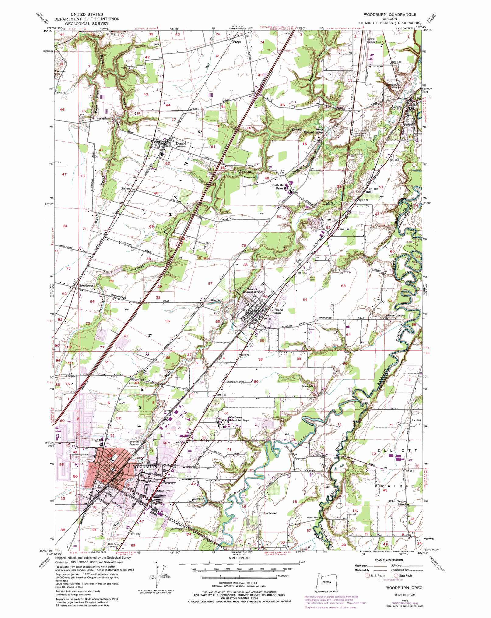
Woodburn Topo Map Oregon
To zoom in, hover over the map of Woodburn
USGS Topo Quad 45122b7 - 1:24,000 scale
| Topo Map Name: | Woodburn |
| USGS Topo Quad ID: | 45122b7 |
| Print Size: | ca. 21 1/4" wide x 27" high |
| Southeast Coordinates: | 45.125° N latitude / 122.75° W longitude |
| Map Center Coordinates: | 45.1875° N latitude / 122.8125° W longitude |
| U.S. State: | OR |
| Filename: | o45122b7.jpg |
| Download Map JPG Image: | Woodburn topo map 1:24,000 scale |
| Map Type: | Topographic |
| Topo Series: | 7.5´ |
| Map Scale: | 1:24,000 |
| Source of Map Images: | United States Geological Survey (USGS) |
| Alternate Map Versions: |
Woodburn OR 1956, updated 1958 Download PDF Buy paper map Woodburn OR 1956, updated 1971 Download PDF Buy paper map Woodburn OR 1956, updated 1985 Download PDF Buy paper map Woodburn OR 1956, updated 1985 Download PDF Buy paper map Woodburn OR 2011 Download PDF Buy paper map Woodburn OR 2014 Download PDF Buy paper map |
1:24,000 Topo Quads surrounding Woodburn
Laurelwood |
Scholls |
Beaverton |
Lake Oswego |
Gladstone |
Dundee |
Newberg |
Sherwood |
Canby |
Oregon City |
Dayton |
Saint Paul |
Woodburn |
Yoder |
Molalla |
Mission Bottom |
Gervais |
Silverton |
Scotts Mills |
Wilhoit |
Salem West |
Salem East |
Stayton Ne |
Drake Crossing |
Elk Prairie |
> Back to 45122a1 at 1:100,000 scale
> Back to 45122a1 at 1:250,000 scale
> Back to U.S. Topo Maps home
Woodburn topo map: Gazetteer
Woodburn: Bridges
Killin Bridge elevation 32m 104′Morris Bridge elevation 38m 124′
Woodburn: Dams
Fredericks Dam elevation 41m 134′Woodburn: Flats
Elliott Prairie elevation 59m 193′Woodburn: Parks
Centennial Park elevation 58m 190′Cowan Park elevation 56m 183′
Heritage Park elevation 57m 187′
Hermanson Park I elevation 56m 183′
Hermanson Park II elevation 56m 183′
Hermanson Park III elevation 56m 183′
Legion Park elevation 56m 183′
Library Park elevation 57m 187′
Locomotive Park elevation 57m 187′
Nelson Park elevation 56m 183′
North Front Street Park elevation 54m 177′
Senior Estates Park elevation 57m 187′
Settlemier Park elevation 56m 183′
Woodburn Downtown Plaza elevation 57m 187′
Wyffle Park elevation 54m 177′
Woodburn: Populated Places
Aurora elevation 48m 157′Donald elevation 60m 196′
Elliott Prairie elevation 59m 193′
Hubbard elevation 56m 183′
Woodburn elevation 57m 187′
Woodburn: Post Offices
Aurora Post Office elevation 48m 157′Broadacres Post Office (historical) elevation 56m 183′
Donald Post Office elevation 60m 196′
Handy Post Office (historical) elevation 37m 121′
Highway Post Office (historical) elevation 58m 190′
Hubbard Post Office elevation 56m 183′
Rome Post Office (historical) elevation 56m 183′
Woodburn Post Office elevation 56m 183′
Woodburn: Reservoirs
Bronec Reservoir elevation 55m 180′Fowler Reservoir elevation 48m 157′
Fredericks Reservoir elevation 41m 134′
Fry Reservoir elevation 49m 160′
Hoch Reservoir elevation 51m 167′
O'Neal Reservoir elevation 54m 177′
Serres Reservoir elevation 31m 101′
Woodburn: Springs
Giesy Mineral Spring elevation 37m 121′Hubbard Mineral Spring elevation 42m 137′
Woodburn: Streams
Brandy Creek elevation 35m 114′Butte Creek elevation 31m 101′
Deer Creek elevation 43m 141′
Fry Creek elevation 40m 131′
Kraus Creek elevation 52m 170′
Mill Creek elevation 27m 88′
Rock Creek elevation 28m 91′
Rock Creek elevation 29m 95′
Senecal Creek elevation 37m 121′
Seven-up Creek elevation 35m 114′
Yergen Creek elevation 31m 101′
Woodburn digital topo map on disk
Buy this Woodburn topo map showing relief, roads, GPS coordinates and other geographical features, as a high-resolution digital map file on DVD: