Redland Topo Map Oregon
To zoom in, hover over the map of Redland
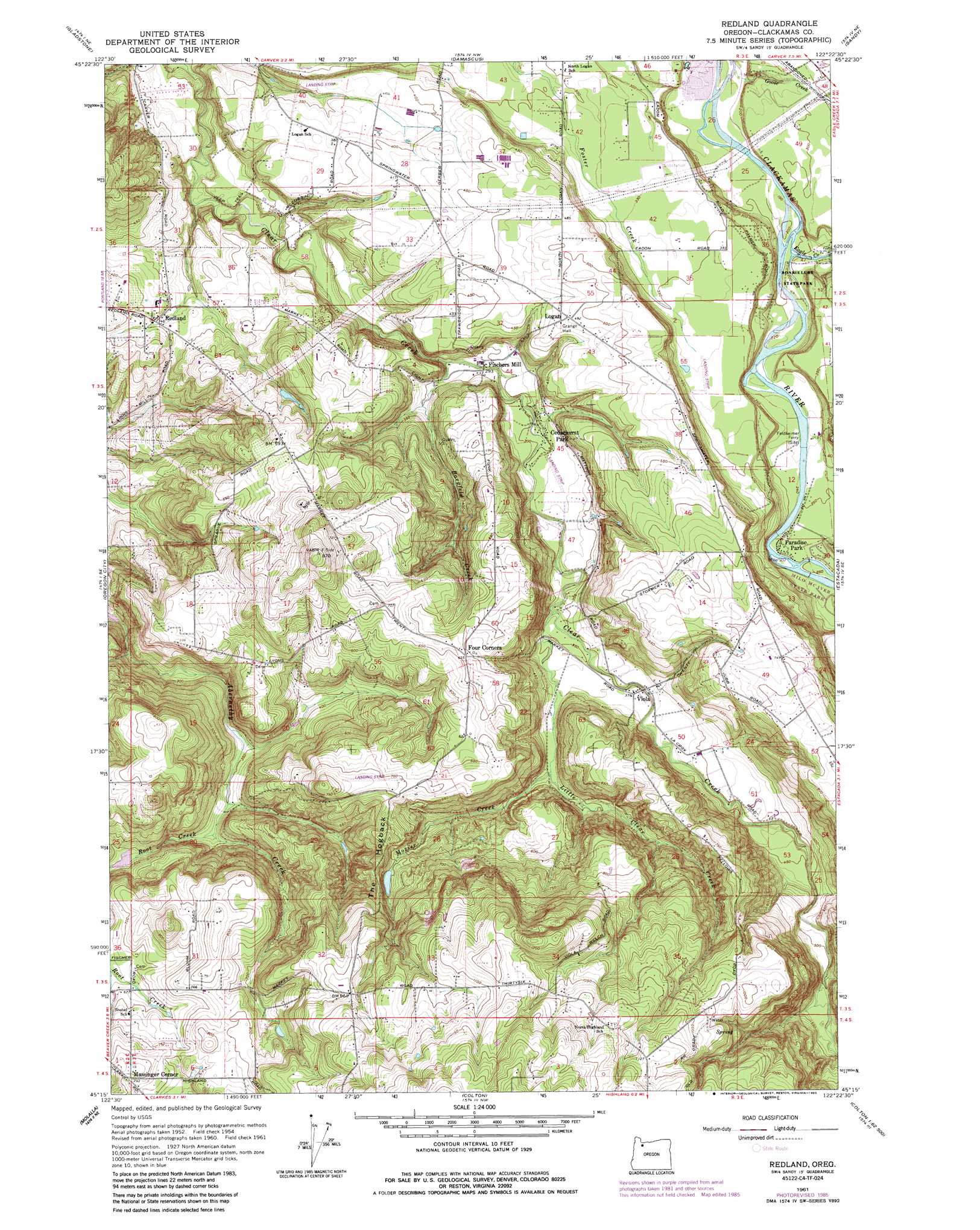
USGS Topo Quad 45122c4 - 1:24,000 scale
| Topo Map Name: | Redland |
| USGS Topo Quad ID: | 45122c4 |
| Print Size: | ca. 21 1/4" wide x 27" high |
| Southeast Coordinates: | 45.25° N latitude / 122.375° W longitude |
| Map Center Coordinates: | 45.3125° N latitude / 122.4375° W longitude |
| U.S. State: | OR |
| Filename: | o45122c4.jpg |
| Download Map JPG Image: | Redland topo map 1:24,000 scale |
| Map Type: | Topographic |
| Topo Series: | 7.5´ |
| Map Scale: | 1:24,000 |
| Source of Map Images: | United States Geological Survey (USGS) |
| Alternate Map Versions: |
Redland OR 1954, updated 1956 Download PDF Buy paper map Redland OR 1961, updated 1961 Download PDF Buy paper map Redland OR 1961, updated 1971 Download PDF Buy paper map Redland OR 1961, updated 1977 Download PDF Buy paper map Redland OR 1961, updated 1985 Download PDF Buy paper map Redland OR 1961, updated 1985 Download PDF Buy paper map Redland OR 2011 Download PDF Buy paper map Redland OR 2014 Download PDF Buy paper map |
1:24,000 Topo Quads surrounding Redland
Portland |
Mount Tabor |
Camas |
Washougal |
Bridal Veil |
Lake Oswego |
Gladstone |
Damascus |
Sandy |
Bull Run |
Canby |
Oregon City |
Redland |
Estacada |
Cherryville |
Yoder |
Molalla |
Colton |
Elwood |
Bedford Point |
Scotts Mills |
Wilhoit |
Fernwood |
Soosap Peak |
Wanderers Peak |
> Back to 45122a1 at 1:100,000 scale
> Back to 45122a1 at 1:250,000 scale
> Back to U.S. Topo Maps home
Redland topo map: Gazetteer
Redland: Airports
Big Sky Ranch Airstrip elevation 114m 374′McGill Airstrip elevation 114m 374′
Sabin Airport elevation 138m 452′
Skyhill Airfield elevation 221m 725′
Warner Airstrip elevation 171m 561′
Redland: Parks
Bonnie Lure State Park elevation 71m 232′Lyons View Park elevation 178m 583′
Redland: Populated Places
Cedarhurst Park elevation 98m 321′Logan elevation 149m 488′
North Highland elevation 344m 1128′
Paradise Park elevation 78m 255′
Redland elevation 107m 351′
Viola elevation 114m 374′
Redland: Post Offices
Logan Post Office (historical) elevation 149m 488′Norton Post Office (historical) elevation 173m 567′
Redland Post Office (historical) elevation 107m 351′
Shubel Post Office (historical) elevation 208m 682′
Viola Post Office (historical) elevation 114m 374′
Redland: Reservoirs
Briscoe Reservoir elevation 122m 400′Mint Lake elevation 148m 485′
Redland: Ridges
The Hogback elevation 224m 734′Redland: Streams
Bargfeld Creek elevation 84m 275′Eagle Creek elevation 60m 196′
Goose Creek elevation 56m 183′
Little Clear Creek elevation 104m 341′
Martin Creek elevation 112m 367′
Mosier Creek elevation 116m 380′
Root Creek elevation 113m 370′
Tennys Creek elevation 120m 393′
Redland digital topo map on disk
Buy this Redland topo map showing relief, roads, GPS coordinates and other geographical features, as a high-resolution digital map file on DVD: