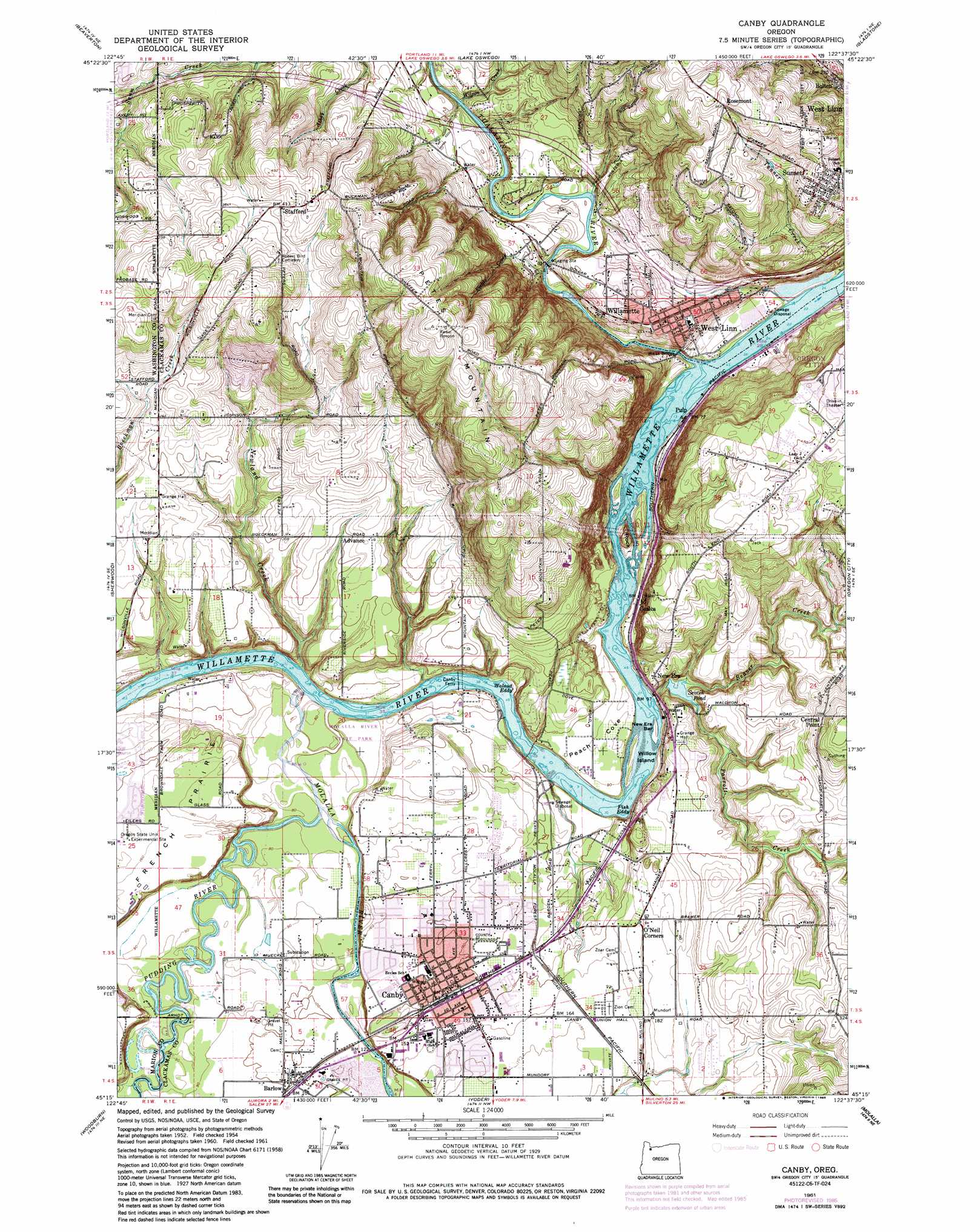
Canby Topo Map Oregon
To zoom in, hover over the map of Canby
USGS Topo Quad 45122c6 - 1:24,000 scale
| Topo Map Name: | Canby |
| USGS Topo Quad ID: | 45122c6 |
| Print Size: | ca. 21 1/4" wide x 27" high |
| Southeast Coordinates: | 45.25° N latitude / 122.625° W longitude |
| Map Center Coordinates: | 45.3125° N latitude / 122.6875° W longitude |
| U.S. State: | OR |
| Filename: | o45122c6.jpg |
| Download Map JPG Image: | Canby topo map 1:24,000 scale |
| Map Type: | Topographic |
| Topo Series: | 7.5´ |
| Map Scale: | 1:24,000 |
| Source of Map Images: | United States Geological Survey (USGS) |
| Alternate Map Versions: |
Canby OR 1954, updated 1957 Download PDF Buy paper map Canby OR 1961 Download PDF Buy paper map Canby OR 1961, updated 1962 Download PDF Buy paper map Canby OR 1961, updated 1972 Download PDF Buy paper map Canby OR 1961, updated 1985 Download PDF Buy paper map Canby OR 1975, updated 1977 Download PDF Buy paper map Canby OR 2011 Download PDF Buy paper map Canby OR 2014 Download PDF Buy paper map |
1:24,000 Topo Quads surrounding Canby
Hillsboro |
Linnton |
Portland |
Mount Tabor |
Camas |
Scholls |
Beaverton |
Lake Oswego |
Gladstone |
Damascus |
Newberg |
Sherwood |
Canby |
Oregon City |
Redland |
Saint Paul |
Woodburn |
Yoder |
Molalla |
Colton |
Gervais |
Silverton |
Scotts Mills |
Wilhoit |
Fernwood |
> Back to 45122a1 at 1:100,000 scale
> Back to 45122a1 at 1:250,000 scale
> Back to U.S. Topo Maps home
Canby topo map: Gazetteer
Canby: Airports
Dietz Airport elevation 55m 180′Francis Davis Airport elevation 133m 436′
Canby: Bars
New Era Bar elevation 19m 62′Canby: Basins
Peach Cove elevation 28m 91′Canby: Bridges
Fields Bridge elevation 28m 91′Knights Bridge elevation 26m 85′
Red Bridge elevation 26m 85′
Weiss Bridge elevation 18m 59′
Canby: Crossings
Interchange 3 elevation 72m 236′Interchange 6 elevation 46m 150′
Canby: Dams
Hershiser Dam elevation 113m 370′Sevcik Dam elevation 24m 78′
Canby: Islands
Rock Island elevation 44m 144′Willow Island elevation 19m 62′
Canby: Parks
13th Avenue City Park elevation 54m 177′19th Avenue City Park elevation 29m 95′
Arneson City Park elevation 46m 150′
Atfalati City Park elevation 51m 167′
Canby Community Park elevation 27m 88′
Canby Regional Park elevation 31m 101′
Canemah City Park elevation 62m 203′
Eco City Park elevation 31m 101′
Fields Bridge Park elevation 30m 98′
Hebb County Park elevation 30m 98′
Ibach Nature Park elevation 181m 593′
Locust City Park elevation 47m 154′
Madrona Open Space elevation 140m 459′
Maple Street City Park elevation 44m 144′
Molalla River State Park elevation 28m 91′
North Willamette Neighborhood Park elevation 73m 239′
Oppenlander Field elevation 210m 688′
Sahallie-Illahee Park elevation 165m 541′
Sunset Park elevation 163m 534′
Tanner Creek Park elevation 182m 597′
Wait City Park elevation 48m 157′
Willamette Park elevation 28m 91′
Willow Creek/Landove City Park elevation 68m 223′
Canby: Populated Places
Barlow elevation 32m 104′Bolton elevation 73m 239′
Canby elevation 48m 157′
Central Point elevation 88m 288′
New Era elevation 57m 187′
O'Neil Corners elevation 55m 180′
Rosemont elevation 204m 669′
Stafford elevation 127m 416′
Stringtown (historical) elevation 21m 68′
Sunset elevation 171m 561′
Willamette elevation 51m 167′
Canby: Post Offices
Barlow Post Office (historical) elevation 32m 104′Canby Post Office elevation 48m 157′
New Era Post Office (historical) elevation 57m 187′
Stafford Post Office (historical) elevation 127m 416′
Willamette Post Office (historical) elevation 51m 167′
Canby: Rapids
Fish Eddy elevation 17m 55′Walnut Eddy elevation 17m 55′
Canby: Reservoirs
Aurora Reservoirs elevation 72m 236′Hershiser Reservoir elevation 113m 370′
Sevcik Pond elevation 24m 78′
Canby: Ridges
Petes Mountain elevation 255m 836′Canby: Streams
Beaver Creek elevation 17m 55′Fields Creek elevation 34m 111′
Molalla River elevation 21m 68′
Newland Creek elevation 17m 55′
Parrott Creek elevation 26m 85′
Petes Mountain Creek elevation 19m 62′
Pudding River elevation 20m 65′
Tanner Creek elevation 23m 75′
Tualatin River elevation 18m 59′
Wilson Creek elevation 30m 98′
Canby digital topo map on disk
Buy this Canby topo map showing relief, roads, GPS coordinates and other geographical features, as a high-resolution digital map file on DVD: