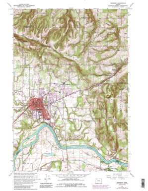
Newberg Topo Map Oregon
To zoom in, hover over the map of Newberg
USGS Topo Quad 45122c8 - 1:24,000 scale
| Topo Map Name: | Newberg |
| USGS Topo Quad ID: | 45122c8 |
| Print Size: | ca. 21 1/4" wide x 27" high |
| Southeast Coordinates: | 45.25° N latitude / 122.875° W longitude |
| Map Center Coordinates: | 45.3125° N latitude / 122.9375° W longitude |
| U.S. State: | OR |
| Filename: | o45122c8.jpg |
| Download Map JPG Image: | Newberg topo map 1:24,000 scale |
| Map Type: | Topographic |
| Topo Series: | 7.5´ |
| Map Scale: | 1:24,000 |
| Source of Map Images: | United States Geological Survey (USGS) |
| Alternate Map Versions: |
Newberg OR 1954, updated 1957 Download PDF Buy paper map Newberg OR 1961, updated 1961 Download PDF Buy paper map Newberg OR 1961, updated 1971 Download PDF Buy paper map Newberg OR 1961, updated 1985 Download PDF Buy paper map Newberg OR 1961, updated 1985 Download PDF Buy paper map Newberg OR 2011 Download PDF Buy paper map Newberg OR 2014 Download PDF Buy paper map |
1:24,000 Topo Quads surrounding Newberg
> Back to 45122a1 at 1:100,000 scale
> Back to 45122a1 at 1:250,000 scale
> Back to U.S. Topo Maps home
Newberg topo map: Gazetteer
Newberg: Airports
Sportsman Airpark elevation 48m 157′Newberg: Islands
Ash Island elevation 23m 75′Newberg: Lakes
Skookum Lakes elevation 24m 78′Newberg: Parks
Armory Park elevation 47m 154′Babe Nicklous Pool Park elevation 63m 206′
Buckley Park elevation 62m 203′
Champoeg Monument elevation 32m 104′
Champoeg State Park elevation 31m 101′
College Park elevation 66m 216′
Darnell Wright Softball Complex elevation 64m 209′
Ewing Young Park elevation 39m 127′
Gladys Park elevation 69m 226′
Hoover Park elevation 50m 164′
Jaquith Park elevation 55m 180′
Memorial Park elevation 51m 167′
Oak Knoll Tot Lot elevation 81m 265′
Parrett Mountain Access elevation 26m 85′
Rogers Landing County Park elevation 38m 124′
Rotary Centennial Park elevation 60m 196′
Scott Leavitt Park elevation 52m 170′
Spring Meadow Park elevation 64m 209′
Newberg: Populated Places
Chehalem elevation 105m 344′Newberg elevation 53m 173′
Springbrook elevation 77m 252′
Newberg: Post Offices
Chehalem Post Office (historical) elevation 105m 344′Newberg Post Office elevation 53m 173′
Rex Post Office (historical) elevation 132m 433′
Springbrook Post Office (historical) elevation 77m 252′
Newberg: Reservoirs
Burgale Reservoir elevation 209m 685′Denison Reservoir elevation 183m 600′
Edstrom Reservoir elevation 98m 321′
Elwart Reservoir elevation 55m 180′
Freitag Reservoir elevation 100m 328′
Lockhart Reservoir elevation 61m 200′
Pamplins Pond elevation 138m 452′
Schaad Reservoir elevation 80m 262′
Shady Dell Reservoir elevation 115m 377′
Verley Pond elevation 196m 643′
Newberg: Ridges
Dog Ridge elevation 52m 170′Laurel Ridge elevation 239m 784′
Newberg: Springs
Gordon Spring elevation 218m 715′Howell Spring elevation 228m 748′
Oliver Spring elevation 239m 784′
Skelton Spring elevation 276m 905′
Snider Spring elevation 270m 885′
Newberg: Streams
Bell Road Creek elevation 80m 262′Champoeg Creek elevation 19m 62′
Chehalem Creek elevation 18m 59′
Fir Clearing Creek elevation 103m 337′
Harvey Creek elevation 29m 95′
Hess Creek elevation 23m 75′
High Water Slough elevation 19m 62′
Schmeltzer Creek elevation 152m 498′
Spring Brook elevation 19m 62′
Newberg: Summits
Grouse Butte elevation 97m 318′Parrett Mountain elevation 380m 1246′
Newberg: Swamps
Aders Sump elevation 56m 183′Newberg: Valleys
Chehalem Valley elevation 55m 180′Little Hells Canyon elevation 94m 308′
Newberg digital topo map on disk
Buy this Newberg topo map showing relief, roads, GPS coordinates and other geographical features, as a high-resolution digital map file on DVD:


