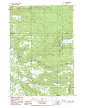
Bull Run Topo Map Oregon
To zoom in, hover over the map of Bull Run
USGS Topo Quad 45122d2 - 1:24,000 scale
| Topo Map Name: | Bull Run |
| USGS Topo Quad ID: | 45122d2 |
| Print Size: | ca. 21 1/4" wide x 27" high |
| Southeast Coordinates: | 45.375° N latitude / 122.125° W longitude |
| Map Center Coordinates: | 45.4375° N latitude / 122.1875° W longitude |
| U.S. State: | OR |
| Filename: | o45122d2.jpg |
| Download Map JPG Image: | Bull Run topo map 1:24,000 scale |
| Map Type: | Topographic |
| Topo Series: | 7.5´ |
| Map Scale: | 1:24,000 |
| Source of Map Images: | United States Geological Survey (USGS) |
| Alternate Map Versions: |
Bull Run OR 1985, updated 1986 Download PDF Buy paper map Bull Run OR 1985, updated 1986 Download PDF Buy paper map Bull Run OR 1997, updated 1999 Download PDF Buy paper map Bull Run OR 2011 Download PDF Buy paper map Bull Run OR 2014 Download PDF Buy paper map |
| FStopo: | US Forest Service topo Bull Run is available: Download FStopo PDF Download FStopo TIF |
1:24,000 Topo Quads surrounding Bull Run
> Back to 45122a1 at 1:100,000 scale
> Back to 45122a1 at 1:250,000 scale
> Back to U.S. Topo Maps home
Bull Run topo map: Gazetteer
Bull Run: Airports
McKinnon Enterprises Airfield elevation 99m 324′Osburn Field elevation 298m 977′
Richs Airfield elevation 208m 682′
Bull Run: Bridges
Revenue Bridge elevation 109m 357′Bull Run: Dams
Big Sandy Dam elevation 221m 725′Bull Run Dam Number 2 elevation 263m 862′
Firwood Veneer Corporation Dam elevation 366m 1200′
Lake Roslyn Dam elevation 200m 656′
Little Sandy Diversion Dam elevation 253m 830′
Marmot Dam (historical) elevation 221m 725′
Osburn Dam elevation 266m 872′
Bull Run: Flats
Walker Prairie elevation 615m 2017′Bull Run: Populated Places
Aims elevation 320m 1049′Bull Run elevation 138m 452′
Firwood elevation 367m 1204′
Bull Run: Post Offices
Aims Post Office (historical) elevation 320m 1049′Camp Namanu Post Office (historical) elevation 91m 298′
Firwood Post Office (historical) elevation 367m 1204′
Bull Run: Reservoirs
Big Sandy Reservoir elevation 221m 725′Bull Run Reservoir Number Two elevation 231m 757′
Firwood Veneer Corporation Reservoir elevation 366m 1200′
Lake Roslyn elevation 200m 656′
Osburn Reservoir elevation 266m 872′
Roslyn Lake elevation 200m 656′
Bull Run: Ridges
Devils Backbone elevation 444m 1456′Bull Run: Springs
Geary Spring elevation 351m 1151′Bull Run: Streams
Badger Creek elevation 170m 557′Beaver Creek elevation 292m 958′
Bowman Creek elevation 218m 715′
Bull Run River elevation 74m 242′
Cat Creek elevation 123m 403′
Deer Creek elevation 84m 275′
Kotzman Creek elevation 200m 656′
Laughing Water Creek elevation 122m 400′
Little Sandy River elevation 137m 449′
Martin Creek elevation 296m 971′
Sievers Creek elevation 312m 1023′
Thompson Creek elevation 266m 872′
Walker Creek elevation 69m 226′
Whisky Creek elevation 246m 807′
Bull Run: Summits
Lookout Point elevation 803m 2634′Walker Peak elevation 736m 2414′
Bull Run: Trails
Little Sandy Trail elevation 458m 1502′Bull Run digital topo map on disk
Buy this Bull Run topo map showing relief, roads, GPS coordinates and other geographical features, as a high-resolution digital map file on DVD:


