Sandy Topo Map Oregon
To zoom in, hover over the map of Sandy
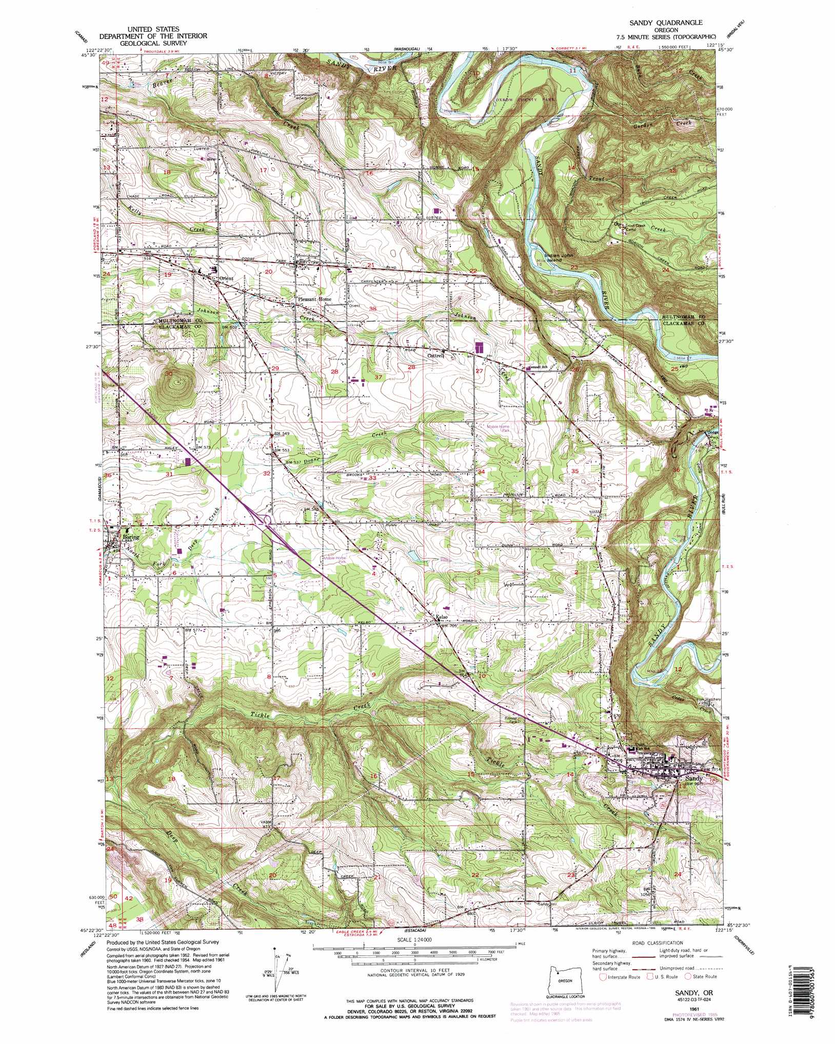
USGS Topo Quad 45122d3 - 1:24,000 scale
| Topo Map Name: | Sandy |
| USGS Topo Quad ID: | 45122d3 |
| Print Size: | ca. 21 1/4" wide x 27" high |
| Southeast Coordinates: | 45.375° N latitude / 122.25° W longitude |
| Map Center Coordinates: | 45.4375° N latitude / 122.3125° W longitude |
| U.S. State: | OR |
| Filename: | o45122d3.jpg |
| Download Map JPG Image: | Sandy topo map 1:24,000 scale |
| Map Type: | Topographic |
| Topo Series: | 7.5´ |
| Map Scale: | 1:24,000 |
| Source of Map Images: | United States Geological Survey (USGS) |
| Alternate Map Versions: |
Sandy OR 1954, updated 1956 Download PDF Buy paper map Sandy OR 1961, updated 1961 Download PDF Buy paper map Sandy OR 1961, updated 1961 Download PDF Buy paper map Sandy OR 1961, updated 1971 Download PDF Buy paper map Sandy OR 1961, updated 1977 Download PDF Buy paper map Sandy OR 1961, updated 1985 Download PDF Buy paper map Sandy OR 1961, updated 1995 Download PDF Buy paper map Sandy OR 2011 Download PDF Buy paper map Sandy OR 2014 Download PDF Buy paper map |
1:24,000 Topo Quads surrounding Sandy
Orchards |
Lacamas Creek |
Larch Mountain |
Bobs Mountain |
Beacon Rock |
Mount Tabor |
Camas |
Washougal |
Bridal Veil |
Multnomah Falls |
Gladstone |
Damascus |
Sandy |
Bull Run |
Brightwood |
Oregon City |
Redland |
Estacada |
Cherryville |
Salmon |
Molalla |
Colton |
Elwood |
Bedford Point |
Three Lynx |
> Back to 45122a1 at 1:100,000 scale
> Back to 45122a1 at 1:250,000 scale
> Back to U.S. Topo Maps home
Sandy topo map: Gazetteer
Sandy: Airports
Flying K Bar J Ranch Airstrip elevation 191m 626′Sandy: Dams
Sester Dam Number 1 elevation 178m 583′Sandy: Islands
Indian John Island elevation 45m 147′Sandy: Lakes
Glendale Ponds elevation 169m 554′Sandy: Parks
Dodge Park elevation 77m 252′Indian John Island Park elevation 44m 144′
Latourette Park elevation 88m 288′
Meinig Memorial Park elevation 294m 964′
Oxbow Regional Park elevation 43m 141′
Pioneer Park elevation 236m 774′
Sandy River Scenic Waterway elevation 67m 219′
Sandy: Populated Places
Boring elevation 152m 498′Cottrell elevation 202m 662′
Kelso elevation 217m 711′
Orient elevation 169m 554′
Pleasant Home elevation 180m 590′
Sandy elevation 299m 980′
Sandy: Post Offices
Boring Post Office elevation 152m 498′Cottrell Post Office (historical) elevation 202m 662′
Kelso Post Office (historical) elevation 217m 711′
Orient Post Office (historical) elevation 169m 554′
Paynesville Post Office (historical) elevation 242m 793′
Pleasant Home Post Office (historical) elevation 180m 590′
Sandy Post Office elevation 299m 980′
Unavilla Post Office (historical) elevation 181m 593′
Sandy: Reservoirs
Belchers Reservoir elevation 164m 538′Bull Frog Reservoir elevation 267m 875′
Fields Reservoirs elevation 98m 321′
Gavins Pond elevation 92m 301′
Hessel Reservoir elevation 179m 587′
Lusted Reservoir elevation 57m 187′
Sandy Reservoirs elevation 218m 715′
Sester Reservoir Number 1 elevation 178m 583′
Sesters Reservoirs elevation 192m 629′
Welling Reservoir elevation 192m 629′
Sandy: Streams
Buck Creek elevation 36m 118′Cedar Creek elevation 112m 367′
Doane Creek elevation 162m 531′
Dolan Creek elevation 162m 531′
Gordon Creek elevation 31m 101′
Lusted Creek elevation 35m 114′
Middle Fork Beaver Creek elevation 128m 419′
North Fork Beaver Creek elevation 97m 318′
South Fork Beaver Creek elevation 97m 318′
South Fork Tickle Creek elevation 148m 485′
Tickle Creek elevation 91m 298′
Trout Creek elevation 31m 101′
Sandy digital topo map on disk
Buy this Sandy topo map showing relief, roads, GPS coordinates and other geographical features, as a high-resolution digital map file on DVD: