Hillsboro Topo Map Oregon
To zoom in, hover over the map of Hillsboro
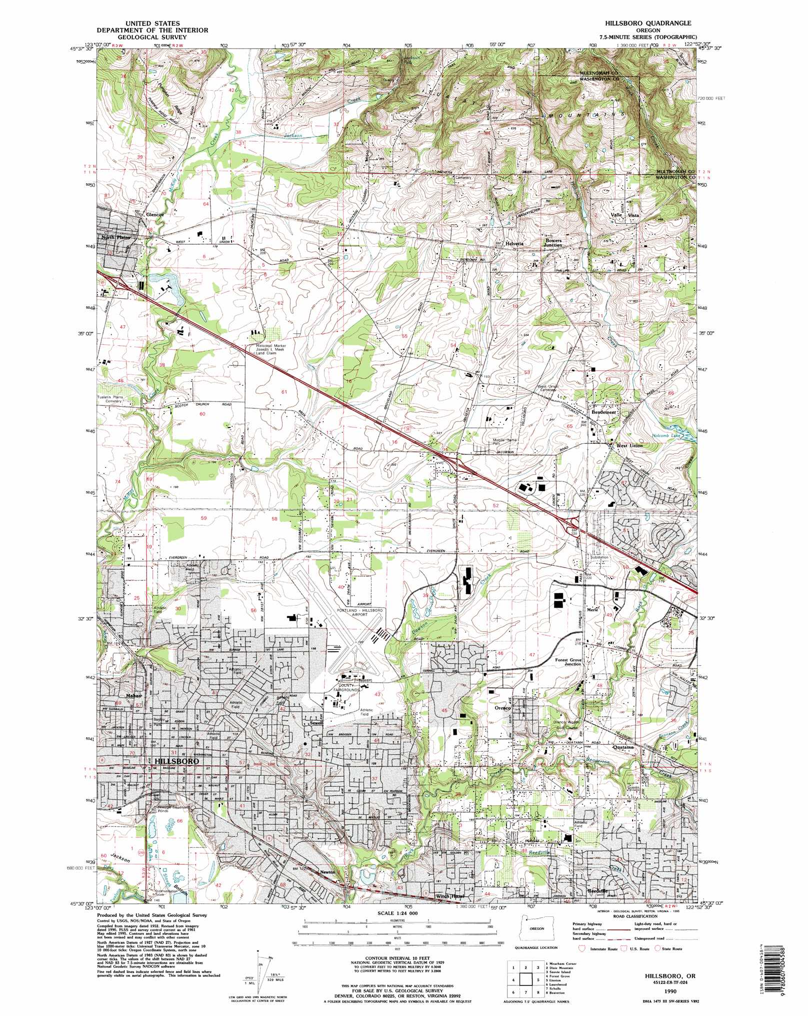
USGS Topo Quad 45122e8 - 1:24,000 scale
| Topo Map Name: | Hillsboro |
| USGS Topo Quad ID: | 45122e8 |
| Print Size: | ca. 21 1/4" wide x 27" high |
| Southeast Coordinates: | 45.5° N latitude / 122.875° W longitude |
| Map Center Coordinates: | 45.5625° N latitude / 122.9375° W longitude |
| U.S. State: | OR |
| Filename: | o45122e8.jpg |
| Download Map JPG Image: | Hillsboro topo map 1:24,000 scale |
| Map Type: | Topographic |
| Topo Series: | 7.5´ |
| Map Scale: | 1:24,000 |
| Source of Map Images: | United States Geological Survey (USGS) |
| Alternate Map Versions: |
Hillsboro OR 1954, updated 1956 Download PDF Buy paper map Hillsboro OR 1961, updated 1961 Download PDF Buy paper map Hillsboro OR 1961, updated 1966 Download PDF Buy paper map Hillsboro OR 1961, updated 1971 Download PDF Buy paper map Hillsboro OR 1961, updated 1977 Download PDF Buy paper map Hillsboro OR 1961, updated 1986 Download PDF Buy paper map Hillsboro OR 1990, updated 1995 Download PDF Buy paper map Hillsboro OR 2011 Download PDF Buy paper map Hillsboro OR 2014 Download PDF Buy paper map |
1:24,000 Topo Quads surrounding Hillsboro
Vernonia |
Bacona |
Chapman |
Saint Helens |
Ridgefield |
Buxton |
Meacham Corner |
Dixie Mountain |
Sauvie Island |
Vancouver |
Gales Creek |
Forest Grove |
Hillsboro |
Linnton |
Portland |
Gaston |
Laurelwood |
Scholls |
Beaverton |
Lake Oswego |
Carlton |
Dundee |
Newberg |
Sherwood |
Canby |
> Back to 45122e1 at 1:100,000 scale
> Back to 45122a1 at 1:250,000 scale
> Back to U.S. Topo Maps home
Hillsboro topo map: Gazetteer
Hillsboro: Airports
Daneilson Airstrip elevation 61m 200′Portland-Hillsboro Airport elevation 62m 203′
Teufels Farm Strip elevation 56m 183′
Hillsboro: Bends
Jackson Bottom elevation 42m 137′Hillsboro: Bridges
Main Street Bridge elevation 49m 160′Hillsboro: Dams
Ornoname 24 Dam elevation 47m 154′Hillsboro: Falls
Jackson Falls elevation 155m 508′Hillsboro: Lakes
Dicks Pond elevation 75m 246′Mullerleile Pond elevation 85m 278′
Hillsboro: Parks
53rd Avenue Community Park elevation 57m 187′Adams Acres Park elevation 68m 223′
Arleda Park elevation 47m 154′
Bagley Park elevation 59m 193′
Bicentennial Park elevation 56m 183′
Central Park elevation 65m 213′
Chantal Village Park elevation 47m 154′
Evergreen Park elevation 61m 200′
Frances Street Park elevation 54m 177′
Francis Street Park elevation 52m 170′
Glencoe Creek Park elevation 56m 183′
Gordon Faber Recreation Complex elevation 71m 232′
Griffin Oaks Park elevation 61m 200′
Harold Eastman Memorial Rose Garden elevation 58m 190′
Hondo Dog Park elevation 68m 223′
Joseph L Meek Land Claim Historical Marker elevation 62m 203′
Lexington Park elevation 47m 154′
McKinney Park elevation 56m 183′
Noble Woods Park elevation 41m 134′
NW Park elevation 75m 246′
Orchard Park elevation 46m 150′
Paula Jean Powerline Park elevation 61m 200′
Reedville Creek Park elevation 63m 206′
Rock Creek Landing Park elevation 72m 236′
Rock Creek North Soccer Fields elevation 69m 226′
Rock Creek Park elevation 55m 180′
Rock Creek Powerline Park elevation 67m 219′
Rock Creek Trail Park elevation 51m 167′
Rosebay Park elevation 65m 213′
Seminole Park elevation 47m 154′
Shadywood Park elevation 60m 196′
Shute Park elevation 55m 180′
Sutherland Meadows Park elevation 51m 167′
Traschel Meadows Park elevation 58m 190′
Turner Creek Park elevation 46m 150′
U J Hamby Park elevation 48m 157′
Walnut Street Park elevation 56m 183′
Hillsboro: Populated Places
Glencoe elevation 54m 177′Helvetia elevation 86m 282′
Hillsboro elevation 59m 193′
North Plains elevation 63m 206′
Orenco elevation 57m 187′
Rockcreek elevation 55m 180′
West Union elevation 76m 249′
Witch Hazel elevation 56m 183′
Hillsboro: Post Offices
Evergreen Post Office elevation 60m 196′Glencoe Post Office (historical) elevation 54m 177′
Hillsboro Post Office elevation 59m 193′
Lenox Post Office (historical) elevation 62m 203′
North Plains Post Office elevation 63m 206′
Orenco Post Office (historical) elevation 57m 187′
West Union Post Office (historical) elevation 76m 249′
Witch Hazel Post Office (historical) elevation 56m 183′
Hillsboro: Reservoirs
Bastion Reservoir elevation 53m 173′Falkenberg Reservoir elevation 56m 183′
Hembree Reservoir elevation 71m 232′
Jackson Quarry Reservoir elevation 71m 232′
Jackson Reservoir elevation 88m 288′
Leichtman Sump elevation 49m 160′
Luscher Reservoir elevation 59m 193′
Ornoname 24 Reservoir elevation 47m 154′
Sunset Log Pond elevation 51m 167′
Teufel Reservoir elevation 50m 164′
Hillsboro: Streams
Beaverton Creek elevation 41m 134′Bronson Creek elevation 45m 147′
Dairy Creek elevation 39m 127′
Dawson Creek elevation 40m 131′
Holcomb Creek elevation 52m 170′
Jackson Creek elevation 51m 167′
Reedville Creek elevation 40m 131′
Storey Creek elevation 47m 154′
Hillsboro: Swamps
Holcomb Lake elevation 52m 170′Hillsboro: Valleys
Waible Gulch elevation 45m 147′Hillsboro digital topo map on disk
Buy this Hillsboro topo map showing relief, roads, GPS coordinates and other geographical features, as a high-resolution digital map file on DVD: