Lacamas Creek Topo Map Washington
To zoom in, hover over the map of Lacamas Creek
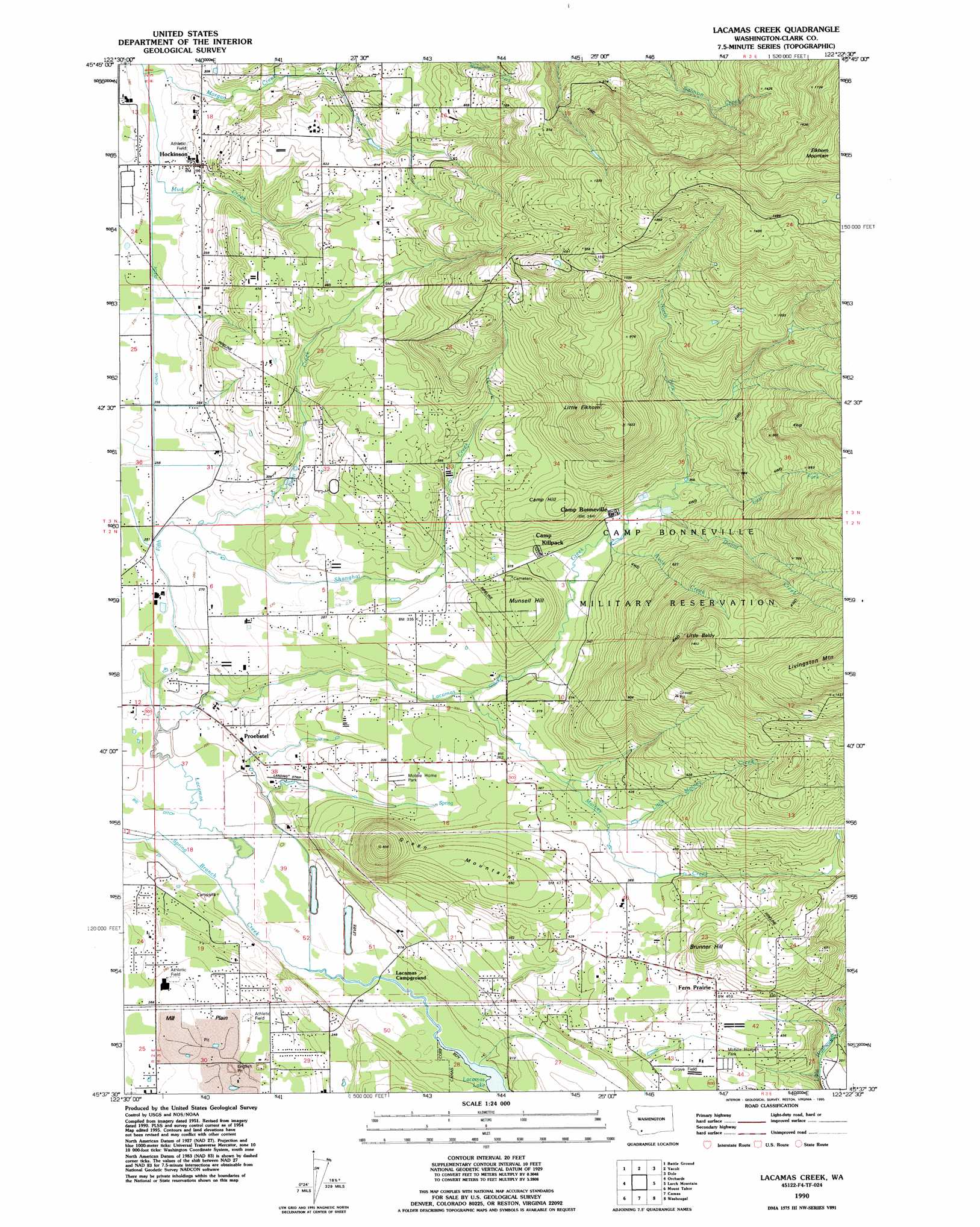
USGS Topo Quad 45122f4 - 1:24,000 scale
| Topo Map Name: | Lacamas Creek |
| USGS Topo Quad ID: | 45122f4 |
| Print Size: | ca. 21 1/4" wide x 27" high |
| Southeast Coordinates: | 45.625° N latitude / 122.375° W longitude |
| Map Center Coordinates: | 45.6875° N latitude / 122.4375° W longitude |
| U.S. State: | WA |
| Filename: | o45122f4.jpg |
| Download Map JPG Image: | Lacamas Creek topo map 1:24,000 scale |
| Map Type: | Topographic |
| Topo Series: | 7.5´ |
| Map Scale: | 1:24,000 |
| Source of Map Images: | United States Geological Survey (USGS) |
| Alternate Map Versions: |
Lacamas Creek WA 1954, updated 1956 Download PDF Buy paper map Lacamas Creek WA 1954, updated 1971 Download PDF Buy paper map Lacamas Creek WA 1954, updated 1977 Download PDF Buy paper map Lacamas Creek WA 1954, updated 1986 Download PDF Buy paper map Lacamas Creek WA 1990, updated 1995 Download PDF Buy paper map Lacamas Creek WA 2011 Download PDF Buy paper map Lacamas Creek WA 2013 Download PDF Buy paper map |
1:24,000 Topo Quads surrounding Lacamas Creek
Woodland |
Ariel |
Amboy |
Yale Dam |
Siouxon Peak |
Ridgefield |
Battle Ground |
Yacolt |
Dole |
Gumboot Mountain |
Vancouver |
Orchards |
Lacamas Creek |
Larch Mountain |
Bobs Mountain |
Portland |
Mount Tabor |
Camas |
Washougal |
Bridal Veil |
Lake Oswego |
Gladstone |
Damascus |
Sandy |
Bull Run |
> Back to 45122e1 at 1:100,000 scale
> Back to 45122a1 at 1:250,000 scale
> Back to U.S. Topo Maps home
Lacamas Creek topo map: Gazetteer
Lacamas Creek: Airports
Grove Field elevation 127m 416′Robert L Taylor Memorial Airpark elevation 77m 252′
Lacamas Creek: Basins
English Pit elevation 76m 249′Lacamas Creek: Canals
Big Ditch elevation 61m 200′China Ditch elevation 80m 262′
Lacamas Creek: Dams
Clark Reservoir Dam elevation 114m 374′Nelson Dam elevation 238m 780′
Lacamas Creek: Flats
Fifth Plain elevation 78m 255′Lacamas Creek: Parks
Lechtenberg Park elevation 58m 190′Lacamas Creek: Populated Places
Fern Prairie elevation 140m 459′Hockinson elevation 94m 308′
Little Elkhorn elevation 331m 1085′
Livingston elevation 99m 324′
Mill Plain elevation 84m 275′
Proebstel elevation 71m 232′
Lacamas Creek: Reservoirs
Clark Reservoir elevation 114m 374′Lacamas Creek: Streams
Buck Creek elevation 103m 337′David Creek elevation 105m 344′
East Fork Lacamas Creek elevation 110m 360′
Fifth Plain Creek elevation 62m 203′
Little Matney Creek elevation 111m 364′
Matney Creek elevation 84m 275′
Mud Creek elevation 81m 265′
North Fork Lacamas Creek elevation 111m 364′
Shanghai Creek elevation 77m 252′
Spring Branch elevation 59m 193′
Lacamas Creek: Summits
Brunner Hill elevation 210m 688′Camp Hill elevation 193m 633′
Green Mountain elevation 245m 803′
Little Baldy elevation 437m 1433′
Munsell Hill elevation 152m 498′
Lacamas Creek digital topo map on disk
Buy this Lacamas Creek topo map showing relief, roads, GPS coordinates and other geographical features, as a high-resolution digital map file on DVD: