Vancouver Topo Map Washington
To zoom in, hover over the map of Vancouver
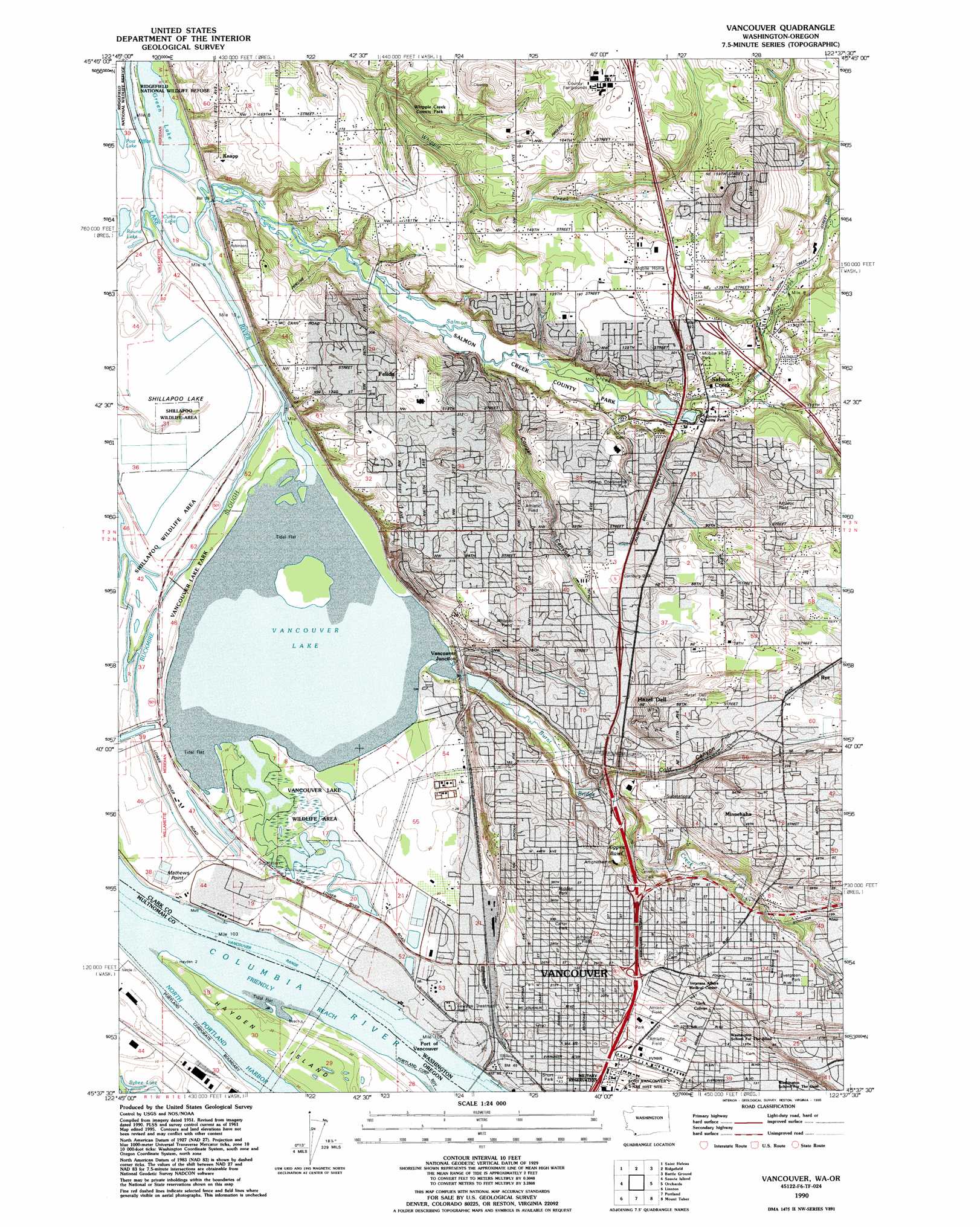
USGS Topo Quad 45122f6 - 1:24,000 scale
| Topo Map Name: | Vancouver |
| USGS Topo Quad ID: | 45122f6 |
| Print Size: | ca. 21 1/4" wide x 27" high |
| Southeast Coordinates: | 45.625° N latitude / 122.625° W longitude |
| Map Center Coordinates: | 45.6875° N latitude / 122.6875° W longitude |
| U.S. States: | WA, OR |
| Filename: | o45122f6.jpg |
| Download Map JPG Image: | Vancouver topo map 1:24,000 scale |
| Map Type: | Topographic |
| Topo Series: | 7.5´ |
| Map Scale: | 1:24,000 |
| Source of Map Images: | United States Geological Survey (USGS) |
| Alternate Map Versions: |
Vancouver WA 1954, updated 1957 Download PDF Buy paper map Vancouver WA 1961, updated 1962 Download PDF Buy paper map Vancouver WA 1961, updated 1962 Download PDF Buy paper map Vancouver WA 1961, updated 1971 Download PDF Buy paper map Vancouver WA 1961, updated 1972 Download PDF Buy paper map Vancouver WA 1961, updated 1978 Download PDF Buy paper map Vancouver WA 1990, updated 1995 Download PDF Buy paper map Vancouver WA 2011 Download PDF Buy paper map Vancouver WA 2014 Download PDF Buy paper map |
1:24,000 Topo Quads surrounding Vancouver
Trenholm |
Deer Island |
Woodland |
Ariel |
Amboy |
Chapman |
Saint Helens |
Ridgefield |
Battle Ground |
Yacolt |
Dixie Mountain |
Sauvie Island |
Vancouver |
Orchards |
Lacamas Creek |
Hillsboro |
Linnton |
Portland |
Mount Tabor |
Camas |
Scholls |
Beaverton |
Lake Oswego |
Gladstone |
Damascus |
> Back to 45122e1 at 1:100,000 scale
> Back to 45122a1 at 1:250,000 scale
> Back to U.S. Topo Maps home
Vancouver topo map: Gazetteer
Vancouver: Airports
Robert L Delanoy Airport elevation 2m 6′Ross Complex Heliport elevation 75m 246′
Vancouver: Basins
Kiggins Bowl elevation 40m 131′Vancouver: Capes
Mathews Point elevation 7m 22′Vancouver: Channels
Friendly Reach elevation 3m 9′Friendly Reach elevation 3m 9′
Vancouver Range elevation 3m 9′
Vancouver Range elevation 3m 9′
Vancouver Upper Channel elevation 3m 9′
Vancouver Upper Channel elevation 3m 9′
Vancouver: Crossings
Interchange 1B elevation 16m 52′Interchange 1C elevation 31m 101′
Interchange 1D elevation 60m 196′
Interchange 2 elevation 52m 170′
Interchange 3 elevation 25m 82′
Interchange 36 elevation 60m 196′
Interchange 4 elevation 56m 183′
Interchange 5 elevation 55m 180′
Interchange 7 elevation 61m 200′
Vancouver: Dams
Clark County Sewage Pond Dam elevation 62m 203′Vancouver: Flats
Shillapoo Lake elevation 4m 13′Vancouver: Guts
Buckmire Slough elevation 3m 9′Vancouver: Harbors
Vancouver Lower Turning Basin elevation 3m 9′Vancouver: Lakes
Curtis Lake elevation 4m 13′Green Lake elevation 3m 9′
Round Lake elevation 3m 9′
Vancouver Lake elevation 3m 9′
Vancouver: Parks
Arnold Park elevation 32m 104′Carter Park elevation 54m 177′
Evergreen Park elevation 55m 180′
Fort Vancouver National Historical Site elevation 20m 65′
Hazel Dell Park elevation 79m 259′
Hidden Park elevation 65m 213′
Leverich Park elevation 28m 91′
Salmon Creek Regional Park elevation 9m 29′
Short Park elevation 16m 52′
Vancouver Lake Park elevation 7m 22′
Whipple Creek Park elevation 51m 167′
Vancouver: Populated Places
Felida elevation 65m 213′Hazel Dell elevation 64m 209′
Knapp elevation 42m 137′
Lake Shore elevation 68m 223′
Lakeshore elevation 67m 219′
Minnehaha elevation 79m 259′
Mount Vista elevation 75m 246′
Officers Row elevation 35m 114′
Rye elevation 81m 265′
Salmon Creek elevation 49m 160′
Vancouver elevation 52m 170′
Vancouver Junction elevation 13m 42′
Vancouver: Post Offices
Downtown Vancouver Post Office elevation 28m 91′Vancouver: Streams
Burnt Bridge Creek elevation 3m 9′Cougar Canyon Creek elevation 6m 19′
LaLonde Creek elevation 24m 78′
Mill Creek elevation 40m 131′
Packard Creek elevation 29m 95′
Pleasant Creek elevation 52m 170′
Salmon Creek elevation 3m 9′
Vancouver: Valleys
Cold Canyon elevation 15m 49′Cougar Canyon elevation 6m 19′
Vancouver digital topo map on disk
Buy this Vancouver topo map showing relief, roads, GPS coordinates and other geographical features, as a high-resolution digital map file on DVD: