Ridgefield Topo Map Washington
To zoom in, hover over the map of Ridgefield
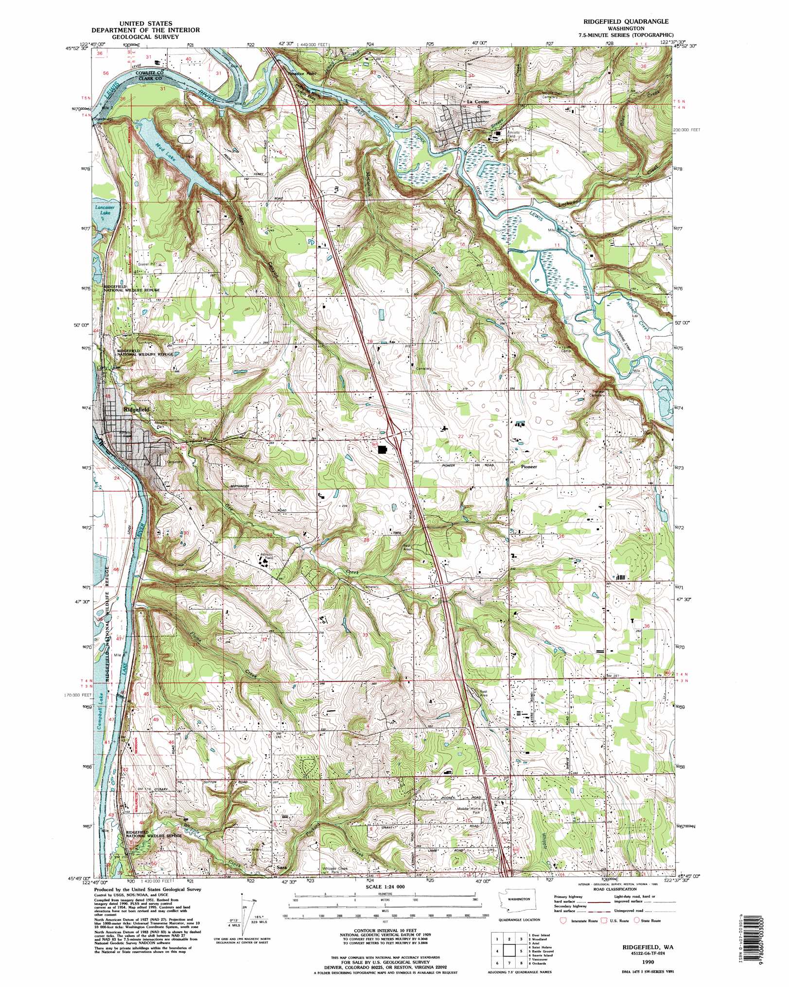
USGS Topo Quad 45122g6 - 1:24,000 scale
| Topo Map Name: | Ridgefield |
| USGS Topo Quad ID: | 45122g6 |
| Print Size: | ca. 21 1/4" wide x 27" high |
| Southeast Coordinates: | 45.75° N latitude / 122.625° W longitude |
| Map Center Coordinates: | 45.8125° N latitude / 122.6875° W longitude |
| U.S. State: | WA |
| Filename: | o45122g6.jpg |
| Download Map JPG Image: | Ridgefield topo map 1:24,000 scale |
| Map Type: | Topographic |
| Topo Series: | 7.5´ |
| Map Scale: | 1:24,000 |
| Source of Map Images: | United States Geological Survey (USGS) |
| Alternate Map Versions: |
Ridgefield WA 1954, updated 1956 Download PDF Buy paper map Ridgefield WA 1954, updated 1972 Download PDF Buy paper map Ridgefield WA 1954, updated 1982 Download PDF Buy paper map Ridgefield WA 1990, updated 1995 Download PDF Buy paper map Ridgefield WA 2011 Download PDF Buy paper map Ridgefield WA 2014 Download PDF Buy paper map |
1:24,000 Topo Quads surrounding Ridgefield
Rainier |
Kalama |
Woolford Creek |
Georges Peak |
Lakeview Peak |
Trenholm |
Deer Island |
Woodland |
Ariel |
Amboy |
Chapman |
Saint Helens |
Ridgefield |
Battle Ground |
Yacolt |
Dixie Mountain |
Sauvie Island |
Vancouver |
Orchards |
Lacamas Creek |
Hillsboro |
Linnton |
Portland |
Mount Tabor |
Camas |
> Back to 45122e1 at 1:100,000 scale
> Back to 45122a1 at 1:250,000 scale
> Back to U.S. Topo Maps home
Ridgefield topo map: Gazetteer
Ridgefield: Airports
Daybreak Airport elevation 8m 26′Ridgefield: Capes
Paradise Point elevation 8m 26′Ridgefield: Crossings
Interchange 14 elevation 84m 275′Interchange 16 elevation 76m 249′
Interchange 9 elevation 88m 288′
Ridgefield: Dams
Buckbee Dam elevation 57m 187′Hiim Reservoir Dam elevation 60m 196′
Ridgefield: Lakes
Lancaster Lake elevation 3m 9′Mud Lake elevation 2m 6′
Quigley Lake elevation 4m 13′
Ridgefield: Parks
Abrams Park elevation 15m 49′Paradise Point State Park elevation 42m 137′
Ridgefield: Populated Places
Baker elevation 94m 308′La Center elevation 32m 104′
Lambert elevation 107m 351′
Pioneer elevation 90m 295′
Ridgefield elevation 34m 111′
Sara elevation 41m 134′
West Pioneer elevation 86m 282′
Ridgefield: Post Offices
Ridgefield Post Office elevation 26m 85′Ridgefield: Reservoirs
Buckbee Reservoir elevation 57m 187′Hiim Reservoir elevation 60m 196′
Ridgefield: Streams
Allen Creek elevation 3m 9′Brezee Creek elevation 4m 13′
East Fork Lewis River elevation 3m 9′
Fairview Schoolhouse Creek elevation 6m 19′
Flume Creek elevation 7m 22′
Jenny Creek elevation 10m 32′
Lockwood Creek elevation 4m 13′
Mason Creek elevation 6m 19′
McCormick Creek elevation 2m 6′
Riley Creek elevation 15m 49′
Whipple Creek elevation 3m 9′
Ridgefield: Valleys
Allen Canyon elevation 4m 13′Ridgefield digital topo map on disk
Buy this Ridgefield topo map showing relief, roads, GPS coordinates and other geographical features, as a high-resolution digital map file on DVD: