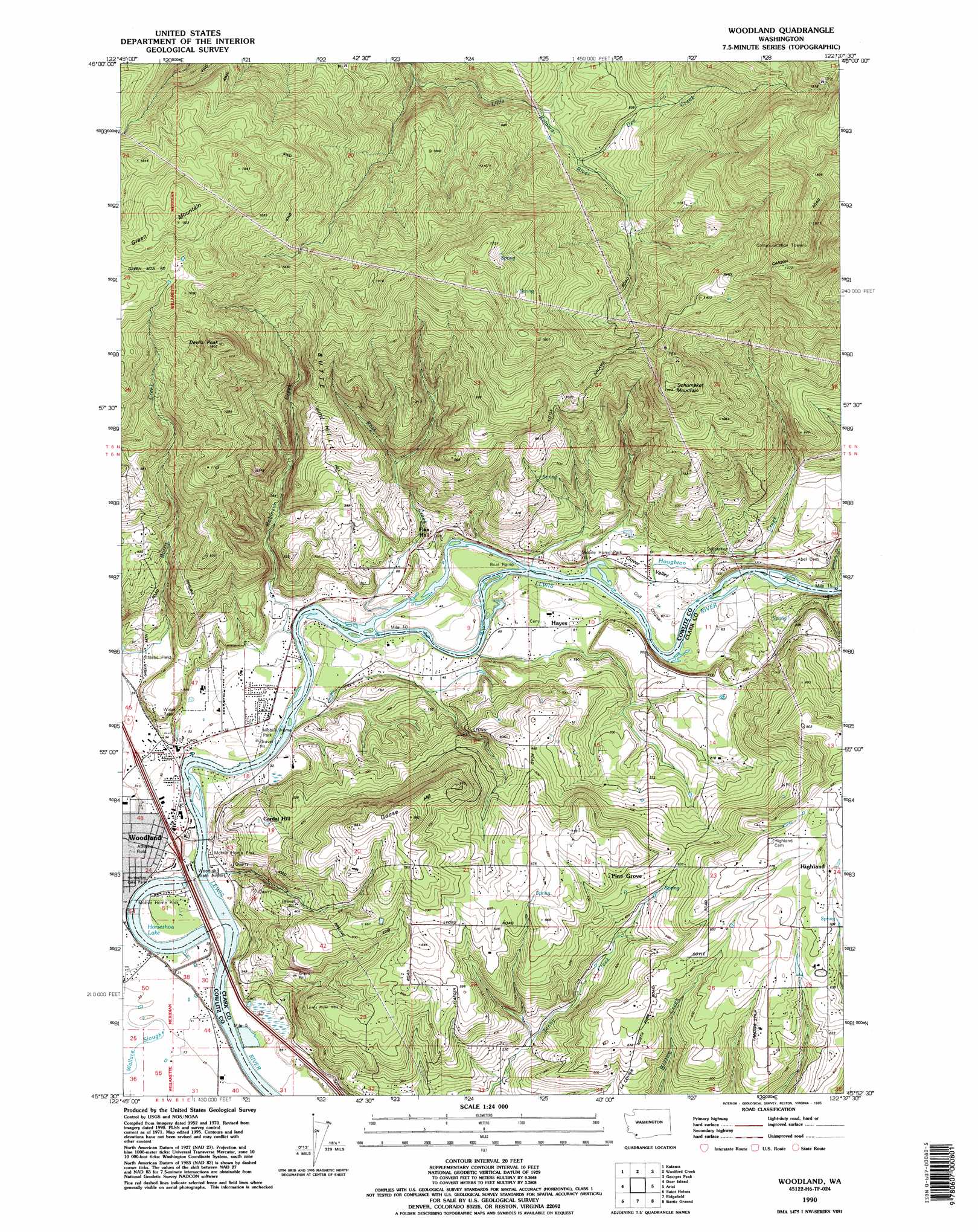
Woodland Topo Map Washington
To zoom in, hover over the map of Woodland
USGS Topo Quad 45122h6 - 1:24,000 scale
| Topo Map Name: | Woodland |
| USGS Topo Quad ID: | 45122h6 |
| Print Size: | ca. 21 1/4" wide x 27" high |
| Southeast Coordinates: | 45.875° N latitude / 122.625° W longitude |
| Map Center Coordinates: | 45.9375° N latitude / 122.6875° W longitude |
| U.S. State: | WA |
| Filename: | o45122h6.jpg |
| Download Map JPG Image: | Woodland topo map 1:24,000 scale |
| Map Type: | Topographic |
| Topo Series: | 7.5´ |
| Map Scale: | 1:24,000 |
| Source of Map Images: | United States Geological Survey (USGS) |
| Alternate Map Versions: |
Woodland WA 1971, updated 1973 Download PDF Buy paper map Woodland WA 1990, updated 1995 Download PDF Buy paper map Woodland WA 2011 Download PDF Buy paper map Woodland WA 2013 Download PDF Buy paper map |
1:24,000 Topo Quads surrounding Woodland
Kelso |
Mount Brynion |
Hemlock Pass |
Wolf Point |
Elk Mountain |
Rainier |
Kalama |
Woolford Creek |
Georges Peak |
Lakeview Peak |
Trenholm |
Deer Island |
Woodland |
Ariel |
Amboy |
Chapman |
Saint Helens |
Ridgefield |
Battle Ground |
Yacolt |
Dixie Mountain |
Sauvie Island |
Vancouver |
Orchards |
Lacamas Creek |
> Back to 45122e1 at 1:100,000 scale
> Back to 45122a1 at 1:250,000 scale
> Back to U.S. Topo Maps home
Woodland topo map: Gazetteer
Woodland: Airports
Lewis River Golf Course Airport elevation 16m 52′Woodland State Airport elevation 11m 36′
Woodland: Capes
Butte Hill elevation 256m 839′Cardai Hill elevation 95m 311′
Woodland: Crossings
Interchange 21 elevation 13m 42′Woodland: Dams
Binford Reservoir Dam elevation 196m 643′Woodland: Lakes
Horseshoe Lake elevation 4m 13′Woodland: Populated Places
Hayes elevation 18m 59′Pine Grove elevation 171m 561′
Woodland elevation 9m 29′
Woodland: Reservoirs
Binford Reservoir elevation 196m 643′Woodland: Streams
Dee Creek elevation 202m 662′Hayes Creek elevation 5m 16′
Houghton Creek elevation 12m 39′
Johnson Creek elevation 11m 36′
Robinson Creek elevation 6m 19′
Ross Creek elevation 3m 9′
Staples Creek elevation 13m 42′
Woodland: Summits
Devils Peak elevation 548m 1797′Goose Hill elevation 293m 961′
Ross Peak elevation 447m 1466′
Schumaker Mountain elevation 431m 1414′
Woodland: Valleys
Clover Valley elevation 10m 32′Woodland digital topo map on disk
Buy this Woodland topo map showing relief, roads, GPS coordinates and other geographical features, as a high-resolution digital map file on DVD: