Mcminnville Topo Map Oregon
To zoom in, hover over the map of Mcminnville
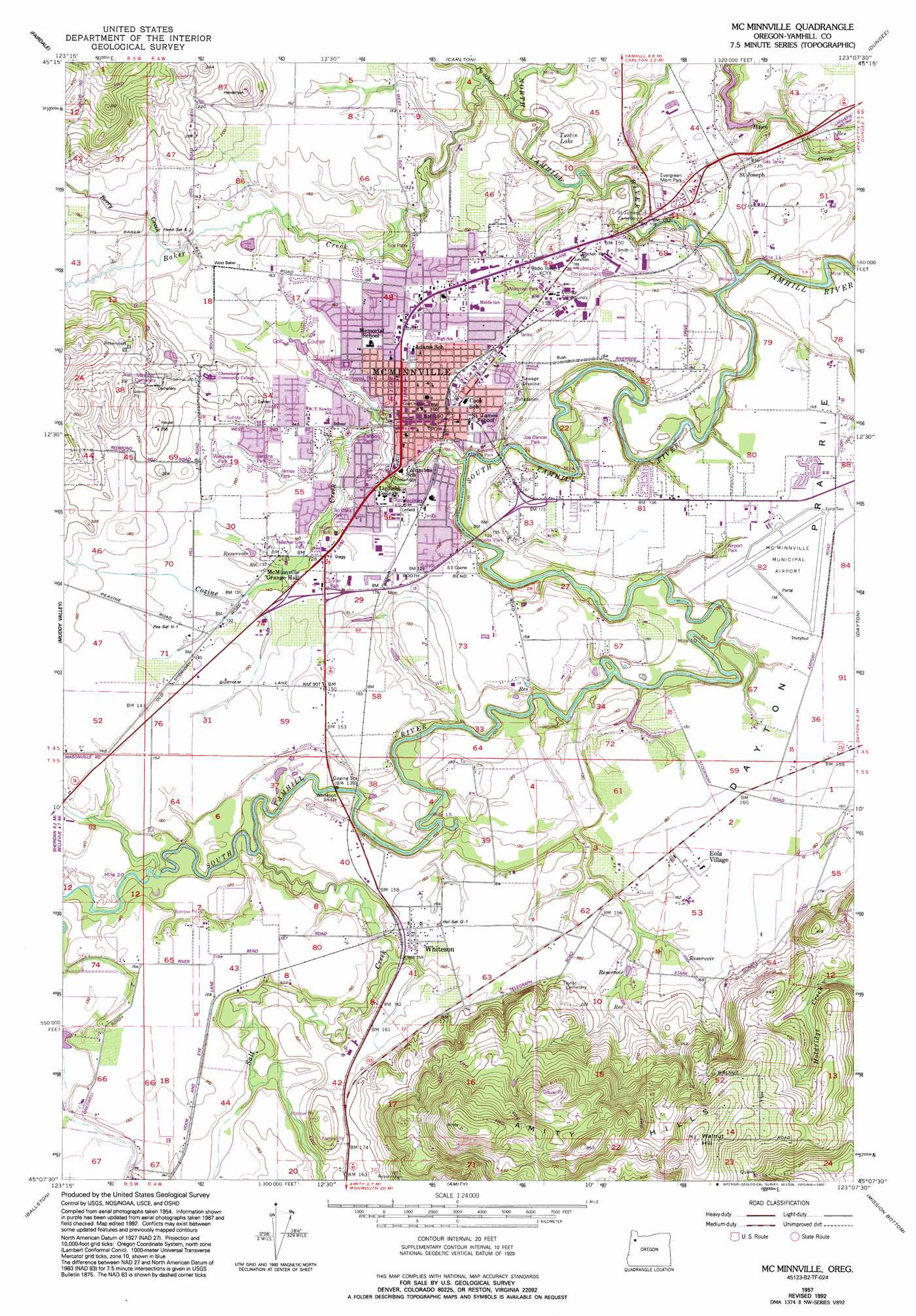
USGS Topo Quad 45123b2 - 1:24,000 scale
| Topo Map Name: | Mcminnville |
| USGS Topo Quad ID: | 45123b2 |
| Print Size: | ca. 21 1/4" wide x 27" high |
| Southeast Coordinates: | 45.125° N latitude / 123.125° W longitude |
| Map Center Coordinates: | 45.1875° N latitude / 123.1875° W longitude |
| U.S. State: | OR |
| Filename: | o45123b2.jpg |
| Download Map JPG Image: | Mcminnville topo map 1:24,000 scale |
| Map Type: | Topographic |
| Topo Series: | 7.5´ |
| Map Scale: | 1:24,000 |
| Source of Map Images: | United States Geological Survey (USGS) |
| Alternate Map Versions: |
Mc Minnville OR 1957, updated 1958 Download PDF Buy paper map Mc Minnville OR 1957, updated 1971 Download PDF Buy paper map Mc Minnville OR 1957, updated 1993 Download PDF Buy paper map McMinnville OR 2011 Download PDF Buy paper map McMinnville OR 2014 Download PDF Buy paper map |
1:24,000 Topo Quads surrounding Mcminnville
Gobblers Knob |
Turner Creek |
Gaston |
Laurelwood |
Scholls |
Trask Mountain |
Fairdale |
Carlton |
Dundee |
Newberg |
Stony Mountain |
Muddy Valley |
Mcminnville |
Dayton |
Saint Paul |
Sheridan |
Ballston |
Amity |
Mission Bottom |
Gervais |
Socialist Valley |
Dallas |
Rickreall |
Salem West |
Salem East |
> Back to 45123a1 at 1:100,000 scale
> Back to 45122a1 at 1:250,000 scale
> Back to U.S. Topo Maps home
Mcminnville topo map: Gazetteer
Mcminnville: Airports
Lafayette Airstrip elevation 52m 170′McMinnville Municipal Airport elevation 46m 150′
Mcminnville: Bridges
Whiteson Bridge elevation 32m 104′Whiteson Dip Bridge elevation 45m 147′
Mcminnville: Dams
Hawn Creek Dam elevation 28m 91′Mcminnville: Flats
Dayton Prairie elevation 48m 157′Mcminnville: Lakes
Stringer Pond elevation 152m 498′Mcminnville: Parks
Airport Park elevation 44m 144′Angella Park (historical) elevation 36m 118′
Bend O River Mini Park elevation 46m 150′
Carlson Park (historical) elevation 36m 118′
Crestwood Park (historical) elevation 45m 147′
Discovery Meadows Community Park elevation 44m 144′
Heather Glen Park elevation 43m 141′
James Park elevation 44m 144′
Jandina Park elevation 46m 150′
Joe Dancer Park elevation 34m 111′
Kingwood Mini Park elevation 45m 147′
Kiwanis Marine Park elevation 37m 121′
L L Stub Stewart State Park elevation 47m 154′
McMinnville City Park elevation 38m 124′
North Evans Mini Park elevation 50m 164′
Quarry Park (historical) elevation 64m 209′
Tall Oaks Park (historical) elevation 37m 121′
Taylor Park elevation 46m 150′
Thompson Park elevation 48m 157′
Tice Park elevation 37m 121′
Westvale Park elevation 49m 160′
Wortman Park elevation 45m 147′
Mcminnville: Populated Places
Eola Village elevation 51m 167′McMinnville elevation 47m 154′
Saint Joseph elevation 44m 144′
Whiteson elevation 51m 167′
Mcminnville: Post Offices
Center Post Office (historical) elevation 50m 164′Linfield College Post Office (historical) elevation 47m 154′
McMinnville Post Office elevation 31m 101′
Saint Joseph Post Office (historical) elevation 44m 144′
Whiteson Post Office (historical) elevation 51m 167′
Mcminnville: Reservoirs
Aebi Reservoir elevation 39m 127′Bourland Reservoir elevation 35m 114′
Hawn Creek Reservoir elevation 28m 91′
Kauer Reservoir elevation 43m 141′
McMinnville Reservoirs elevation 109m 357′
Peavey Reservoir elevation 44m 144′
Mcminnville: Ridges
Amity Hills elevation 241m 790′Mcminnville: Streams
Baker Creek elevation 33m 108′Berry Creek elevation 44m 144′
Cozine Creek elevation 27m 88′
Johnston Creek elevation 38m 124′
North Branch Cozine Creek elevation 37m 121′
North Yamhill River elevation 23m 75′
Panther Creek elevation 46m 150′
Salt Creek elevation 31m 101′
South Yamhill River elevation 22m 72′
Mcminnville: Summits
Walnut Hill elevation 227m 744′Mcminnville: Swamps
Tustin Lake elevation 33m 108′Mcminnville digital topo map on disk
Buy this Mcminnville topo map showing relief, roads, GPS coordinates and other geographical features, as a high-resolution digital map file on DVD: