Springer Mountain Topo Map Oregon
To zoom in, hover over the map of Springer Mountain
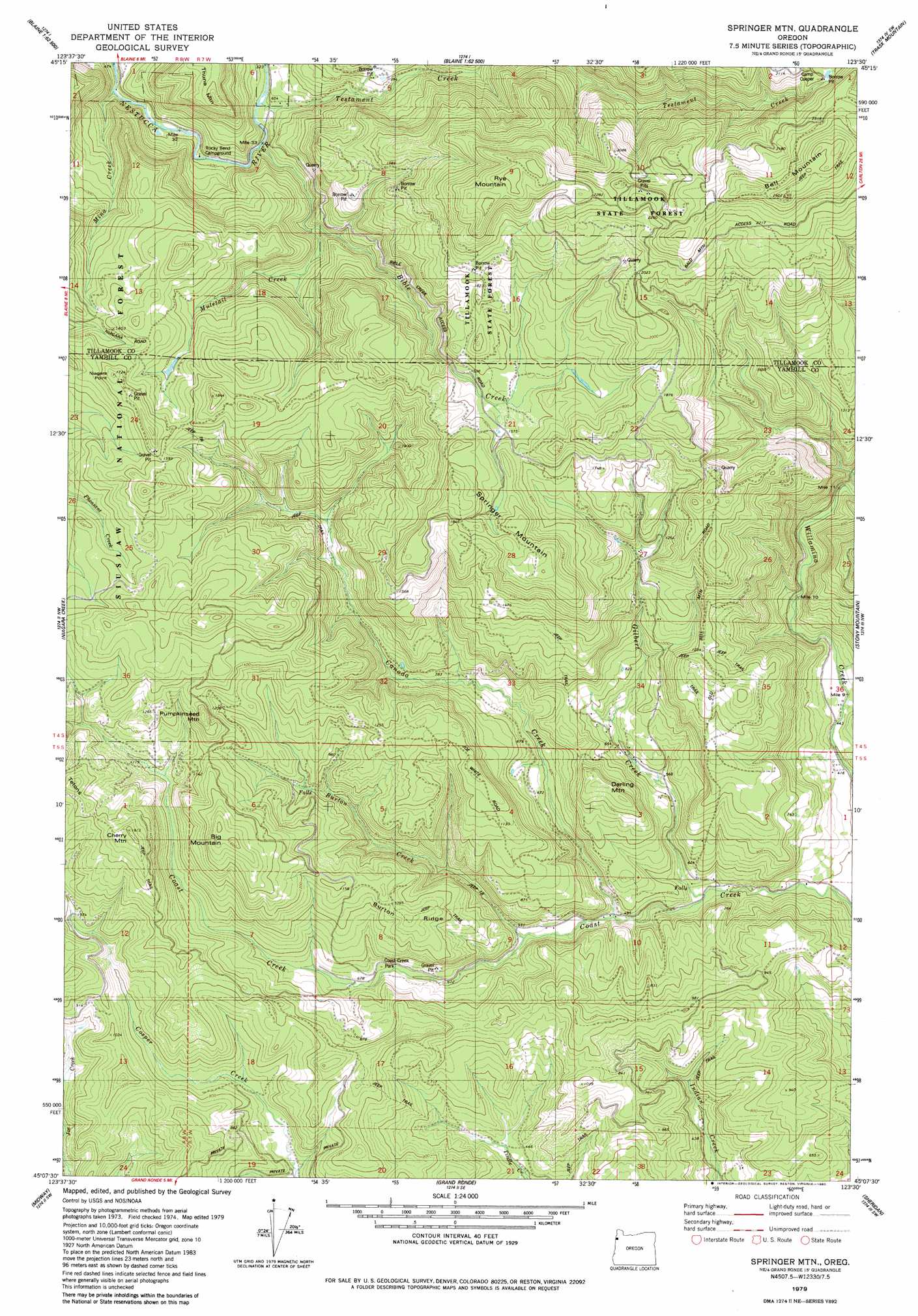
USGS Topo Quad 45123b5 - 1:24,000 scale
| Topo Map Name: | Springer Mountain |
| USGS Topo Quad ID: | 45123b5 |
| Print Size: | ca. 21 1/4" wide x 27" high |
| Southeast Coordinates: | 45.125° N latitude / 123.5° W longitude |
| Map Center Coordinates: | 45.1875° N latitude / 123.5625° W longitude |
| U.S. State: | OR |
| Filename: | o45123b5.jpg |
| Download Map JPG Image: | Springer Mountain topo map 1:24,000 scale |
| Map Type: | Topographic |
| Topo Series: | 7.5´ |
| Map Scale: | 1:24,000 |
| Source of Map Images: | United States Geological Survey (USGS) |
| Alternate Map Versions: |
Springer Mtn OR 1979, updated 1980 Download PDF Buy paper map Springer Mtn OR 1979, updated 1980 Download PDF Buy paper map Springer Mountain OR 2011 Download PDF Buy paper map Springer Mountain OR 2014 Download PDF Buy paper map |
| FStopo: | US Forest Service topo Springer Mountain is available: Download FStopo PDF Download FStopo TIF |
1:24,000 Topo Quads surrounding Springer Mountain
Tillamook |
The Peninsula |
Trask |
Gobblers Knob |
Turner Creek |
Beaver |
Blaine |
Dovre Peak |
Trask Mountain |
Fairdale |
Hebo |
Niagara Creek |
Springer Mountain |
Stony Mountain |
Muddy Valley |
Dolph |
Midway |
Grand Ronde |
Sheridan |
Ballston |
Stott Mountain |
Warnicke Creek |
Laurel Mountain |
Socialist Valley |
Dallas |
> Back to 45123a1 at 1:100,000 scale
> Back to 45122a1 at 1:250,000 scale
> Back to U.S. Topo Maps home
Springer Mountain topo map: Gazetteer
Springer Mountain: Falls
Nenamusa Falls elevation 216m 708′Springer Mountain: Parks
Coast Creek Park elevation 200m 656′Springer Mountain: Populated Places
Nenamusa (historical) elevation 201m 659′Springer Mountain: Post Offices
Blind Slough Post Office (historical) elevation 506m 1660′Nenamusa Post Office (historical) elevation 201m 659′
Springer Mountain: Reservoirs
Camp Cooper Reservoir elevation 600m 1968′Springer Mountain: Ridges
Bell Mountain elevation 781m 2562′Burton Ridge elevation 358m 1174′
Springer Mountain: Streams
Bible Creek elevation 181m 593′Bogue Creek elevation 276m 905′
Burton Creek elevation 160m 524′
Canada Creek elevation 143m 469′
Gilbert Creek elevation 126m 413′
Kennedy Creek elevation 215m 705′
Mina Creek elevation 155m 508′
Muletail Creek elevation 244m 800′
Royce Creek elevation 327m 1072′
Springer Creek elevation 189m 620′
Testament Creek elevation 188m 616′
Wilson Creek elevation 153m 501′
Springer Mountain: Summits
Big Mountain elevation 491m 1610′Cherry Mountain elevation 491m 1610′
Darling Mountain elevation 344m 1128′
Niagara Point elevation 528m 1732′
Pumpkinseed Mountain elevation 468m 1535′
Rye Mountain elevation 736m 2414′
Springer Mountain elevation 576m 1889′
Thune Mountain elevation 455m 1492′
Springer Mountain digital topo map on disk
Buy this Springer Mountain topo map showing relief, roads, GPS coordinates and other geographical features, as a high-resolution digital map file on DVD: