Nestucca Bay Topo Map Oregon
To zoom in, hover over the map of Nestucca Bay
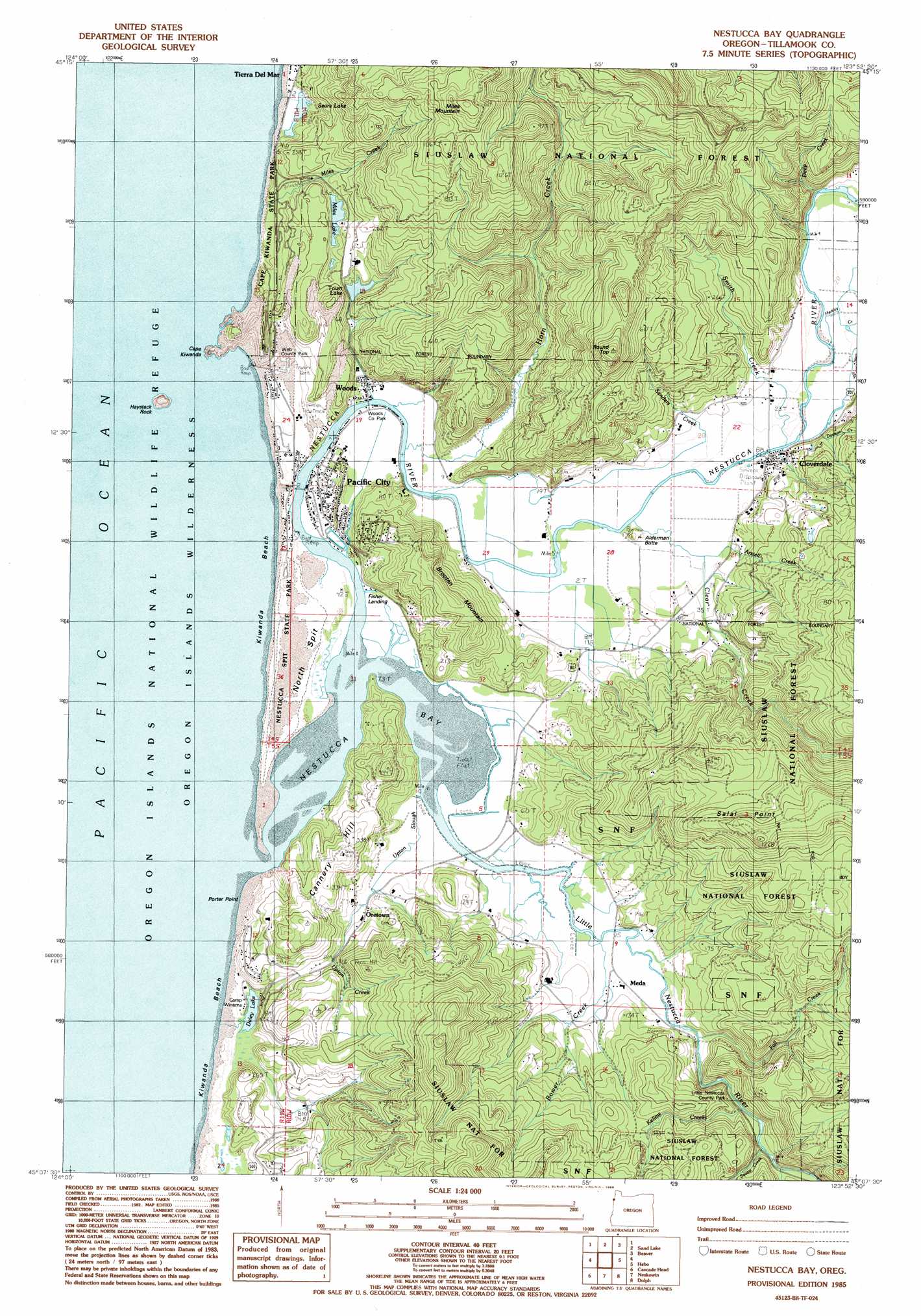
USGS Topo Quad 45123b8 - 1:24,000 scale
| Topo Map Name: | Nestucca Bay |
| USGS Topo Quad ID: | 45123b8 |
| Print Size: | ca. 21 1/4" wide x 27" high |
| Southeast Coordinates: | 45.125° N latitude / 123.875° W longitude |
| Map Center Coordinates: | 45.1875° N latitude / 123.9375° W longitude |
| U.S. State: | OR |
| Filename: | o45123b8.jpg |
| Download Map JPG Image: | Nestucca Bay topo map 1:24,000 scale |
| Map Type: | Topographic |
| Topo Series: | 7.5´ |
| Map Scale: | 1:24,000 |
| Source of Map Images: | United States Geological Survey (USGS) |
| Alternate Map Versions: |
Nestucca Bay OR 1985, updated 1986 Download PDF Buy paper map Nestucca Bay OR 2011 Download PDF Buy paper map Nestucca Bay OR 2014 Download PDF Buy paper map |
| FStopo: | US Forest Service topo Nestucca Bay is available: Download FStopo PDF Download FStopo TIF |
1:24,000 Topo Quads surrounding Nestucca Bay
Netarts |
Tillamook |
The Peninsula |
||
Sand Lake |
Beaver |
Blaine |
||
Nestucca Bay |
Hebo |
Niagara Creek |
||
Neskowin |
Dolph |
Midway |
||
Lincoln City |
Devils Lake |
Stott Mountain |
Warnicke Creek |
> Back to 45123a1 at 1:100,000 scale
> Back to 45122a1 at 1:250,000 scale
> Back to U.S. Topo Maps home
Nestucca Bay topo map: Gazetteer
Nestucca Bay: Airports
Pacific City State Airport elevation 4m 13′Nestucca Bay: Arches
Haystack Rock Arch elevation 2m 6′Nestucca Bay: Bars
North Spit elevation 6m 19′Nestucca Bay: Bays
Nestucca Bay elevation 0m 0′Nestucca Bay: Beaches
Kiwanda Beach elevation 8m 26′Nestucca Bay: Bridges
Meda Bridge elevation 4m 13′Nestucca Bay: Capes
Cape Kiwanda elevation 64m 209′Porter Point elevation 6m 19′
Nestucca Bay: Islands
Haystack Rock elevation 2m 6′Nestucca Bay: Lakes
Miles Lake elevation 77m 252′Sears Lake elevation 5m 16′
Winema Lake elevation 2m 6′
Nestucca Bay: Parks
Bob Straub State Park elevation 5m 16′Cape Kiwanda County Park elevation 10m 32′
Cape Kiwanda State Natural Area elevation 10m 32′
Little Nestucca County Park elevation 64m 209′
Mugg County Park elevation 4m 13′
Webb County Park elevation 14m 45′
Woods County Park elevation 3m 9′
Nestucca Bay: Populated Places
Cloverdale elevation 7m 22′Meda elevation 6m 19′
Oretown elevation 9m 29′
Pacific City elevation 4m 13′
Woods elevation 7m 22′
Nestucca Bay: Post Offices
Cloverdale Post Office elevation 7m 22′Meda Post Office (historical) elevation 6m 19′
Oretown Post Office (historical) elevation 9m 29′
Pacific City Post Office elevation 4m 13′
Woods Post Office (historical) elevation 7m 22′
Nestucca Bay: Reservoirs
Town Lake elevation 71m 232′Nestucca Bay: Ridges
Brooten Mountain elevation 152m 498′Cannery Hill elevation 107m 351′
Salal Point elevation 306m 1003′
Nestucca Bay: Springs
Fletcher Spring elevation 22m 72′Jensen Springs elevation 31m 101′
Morgan Spring elevation 59m 193′
Nestucca Bay: Streams
Arstell Creek elevation 7m 22′Austin Creek elevation 20m 65′
Bower Creek elevation 4m 13′
Clear Creek elevation 5m 16′
Commons Creek elevation 2m 6′
Dawson Creek elevation 7m 22′
Deep Creek elevation 22m 72′
Fall Creek elevation 25m 82′
Hartley Creek elevation 7m 22′
Horn Creek elevation 3m 9′
Kellow Creek elevation 40m 131′
Little Nestucca River elevation 0m 0′
Miles Creek elevation 5m 16′
Nestucca River elevation 0m 0′
Queens Creek elevation 9m 29′
Ray Creek elevation 30m 98′
Sand Creek elevation 57m 187′
Sanders Creek elevation 4m 13′
Smith Creek elevation 6m 19′
Squaw Creek elevation 64m 209′
Three Rivers elevation 8m 26′
Town Creek elevation 4m 13′
Upton Creek elevation 6m 19′
Upton Slough elevation 2m 6′
Winema Creek elevation 3m 9′
Nestucca Bay: Summits
Alderman Butte elevation 37m 121′Miles Mountain elevation 372m 1220′
Round Top elevation 335m 1099′
Nestucca Bay digital topo map on disk
Buy this Nestucca Bay topo map showing relief, roads, GPS coordinates and other geographical features, as a high-resolution digital map file on DVD: