The Peninsula Topo Map Oregon
To zoom in, hover over the map of The Peninsula
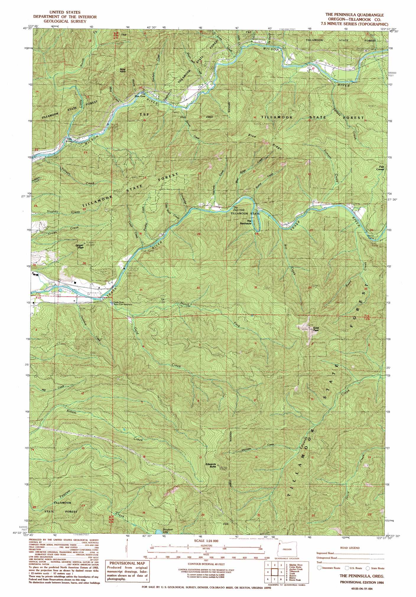
USGS Topo Quad 45123d6 - 1:24,000 scale
| Topo Map Name: | The Peninsula |
| USGS Topo Quad ID: | 45123d6 |
| Print Size: | ca. 21 1/4" wide x 27" high |
| Southeast Coordinates: | 45.375° N latitude / 123.625° W longitude |
| Map Center Coordinates: | 45.4375° N latitude / 123.6875° W longitude |
| U.S. State: | OR |
| Filename: | o45123d6.jpg |
| Download Map JPG Image: | The Peninsula topo map 1:24,000 scale |
| Map Type: | Topographic |
| Topo Series: | 7.5´ |
| Map Scale: | 1:24,000 |
| Source of Map Images: | United States Geological Survey (USGS) |
| Alternate Map Versions: |
The Peninsula OR 1984, updated 1985 Download PDF Buy paper map The Peninsula OR 2011 Download PDF Buy paper map The Peninsula OR 2014 Download PDF Buy paper map |
1:24,000 Topo Quads surrounding The Peninsula
Nehalem |
Foley Peak |
Cook Creek |
Rogers Peak |
Cochran |
Garibaldi |
Kilchis River |
Cedar Butte |
Jordan Creek |
Wood Point |
Netarts |
Tillamook |
The Peninsula |
Trask |
Gobblers Knob |
Sand Lake |
Beaver |
Blaine |
Dovre Peak |
Trask Mountain |
Nestucca Bay |
Hebo |
Niagara Creek |
Springer Mountain |
Stony Mountain |
> Back to 45123a1 at 1:100,000 scale
> Back to 45122a1 at 1:250,000 scale
> Back to U.S. Topo Maps home
The Peninsula topo map: Gazetteer
The Peninsula: Bends
The Peninsula elevation 88m 288′The Peninsula: Bridges
Mills Bridge elevation 199m 652′The Peninsula: Channels
The Blue Hole elevation 22m 72′The Dam Hole elevation 46m 150′
The Peninsula: Parks
Charles Sprague Memorial Wayside elevation 69m 226′Demoley Wilson County Park elevation 53m 173′
Peninsula Day-Use Area elevation 63m 206′
Stones Road Boat Launch elevation 74m 242′
The Peninsula: Ridges
Blue Ridge elevation 631m 2070′The Peninsula: Streams
Bill Creek elevation 89m 291′Blue Ridge Creek elevation 46m 150′
Burton Creek elevation 101m 331′
Cedar Creek elevation 117m 383′
Cedar Creek elevation 24m 78′
Deadman Creek elevation 23m 75′
Fern Creek elevation 33m 108′
Gold Creek elevation 20m 65′
Hanenkrat Creek elevation 14m 45′
Hatchery Creek elevation 22m 72′
Kansas Creek elevation 50m 164′
Little North Fork Wilson River elevation 21m 68′
Little Rock Creek elevation 31m 101′
Ming Creek elevation 25m 82′
Mining Creek elevation 41m 134′
Negro Jack Creek elevation 24m 78′
North Fork Gold Creek elevation 49m 160′
Panther Creek elevation 25m 82′
Rawe Creek elevation 89m 291′
Samson Creek elevation 61m 200′
Sheridan Creek elevation 271m 889′
Slide Creek elevation 47m 154′
Smith Creek elevation 45m 147′
Sylvan Creek elevation 24m 78′
Tillison Creek elevation 18m 59′
Trowbridge Creek elevation 44m 144′
Zig Zag Creek elevation 73m 239′
The Peninsula: Summits
Edwards Butte elevation 958m 3143′Ginger Peak elevation 467m 1532′
Gold Peak elevation 832m 2729′
Ming Point elevation 492m 1614′
The Peninsula digital topo map on disk
Buy this The Peninsula topo map showing relief, roads, GPS coordinates and other geographical features, as a high-resolution digital map file on DVD: