Gales Creek Topo Map Oregon
To zoom in, hover over the map of Gales Creek
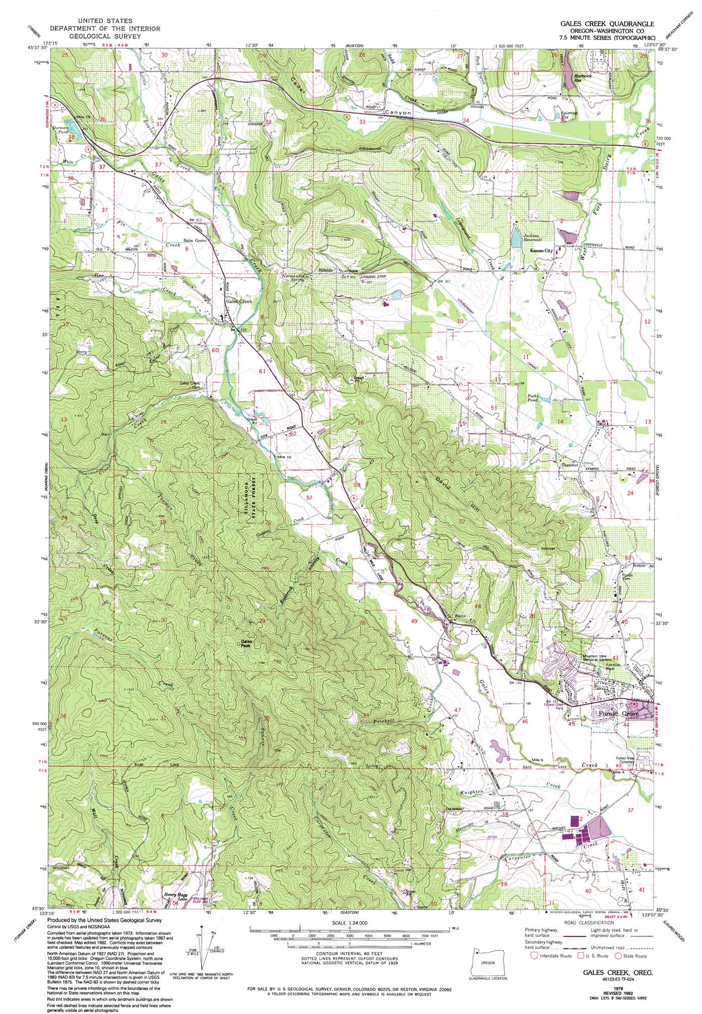
USGS Topo Quad 45123e2 - 1:24,000 scale
| Topo Map Name: | Gales Creek |
| USGS Topo Quad ID: | 45123e2 |
| Print Size: | ca. 21 1/4" wide x 27" high |
| Southeast Coordinates: | 45.5° N latitude / 123.125° W longitude |
| Map Center Coordinates: | 45.5625° N latitude / 123.1875° W longitude |
| U.S. State: | OR |
| Filename: | o45123e2.jpg |
| Download Map JPG Image: | Gales Creek topo map 1:24,000 scale |
| Map Type: | Topographic |
| Topo Series: | 7.5´ |
| Map Scale: | 1:24,000 |
| Source of Map Images: | United States Geological Survey (USGS) |
| Alternate Map Versions: |
Gales Creek OR 1979, updated 1979 Download PDF Buy paper map Gales Creek OR 1979, updated 1983 Download PDF Buy paper map Gales Creek OR 1979, updated 1992 Download PDF Buy paper map Gales Creek OR 2011 Download PDF Buy paper map Gales Creek OR 2014 Download PDF Buy paper map |
1:24,000 Topo Quads surrounding Gales Creek
Sunset Spring |
Clear Creek |
Vernonia |
Bacona |
Chapman |
Cochran |
Timber |
Buxton |
Meacham Corner |
Dixie Mountain |
Wood Point |
Roaring Creek |
Gales Creek |
Forest Grove |
Hillsboro |
Gobblers Knob |
Turner Creek |
Gaston |
Laurelwood |
Scholls |
Trask Mountain |
Fairdale |
Carlton |
Dundee |
Newberg |
> Back to 45123e1 at 1:100,000 scale
> Back to 45122a1 at 1:250,000 scale
> Back to U.S. Topo Maps home
Gales Creek topo map: Gazetteer
Gales Creek: Canals
Lousignont Canal elevation 53m 173′Gales Creek: Dams
Hollis Hartwick Dam elevation 68m 223′Maple Headquarters Dam elevation 59m 193′
Raymond Dierickx Dam elevation 64m 209′
Gales Creek: Flats
Killin Wetlands elevation 80m 262′Gales Creek: Parks
Forest Glen Park elevation 69m 226′Killin Wetlands Park elevation 100m 328′
Knox Ridge City Park elevation 59m 193′
Reuter City Park elevation 66m 216′
Talisman City Park elevation 59m 193′
Thatcher/Loomis City Park elevation 75m 246′
Gales Creek: Populated Places
Balm Grove elevation 94m 308′Gales Creek elevation 88m 288′
Hillside elevation 99m 324′
Kansas City elevation 67m 219′
Watts elevation 66m 216′
Gales Creek: Post Offices
Bakersfield Post Office (historical) elevation 74m 242′Gales Creek Post Office elevation 88m 288′
Joppa Post Office (historical) elevation 93m 305′
Peak Post Office (historical) elevation 61m 200′
Thatcher Post Office (historical) elevation 54m 177′
Gales Creek: Reservoirs
Dorman Pond elevation 112m 367′Feathered Friend Pond elevation 112m 367′
Hartwick Reservoir elevation 59m 193′
Heesacker Reservoir elevation 53m 173′
Howell Reservoirs elevation 78m 255′
Jackson Reservoir elevation 59m 193′
Maple Headquarters Reservoir elevation 59m 193′
Pecks Pond elevation 52m 170′
Raymond Dierickx Reservoir elevation 64m 209′
Shipley Pool elevation 123m 403′
Spiering Reservoir elevation 57m 187′
Gales Creek: Ridges
David Hill elevation 336m 1102′Gales Creek: Springs
Bamford Spring elevation 75m 246′Normandin Spring elevation 123m 403′
Gales Creek: Streams
Alexander Creek elevation 56m 183′Cedar Canyon Creek elevation 56m 183′
Clear Creek elevation 75m 246′
Culver Creek elevation 93m 305′
Deep Creek elevation 123m 403′
Fir Creek elevation 83m 272′
Godfrey Creek elevation 66m 216′
Iler Creek elevation 83m 272′
Kelly Creek elevation 69m 226′
Knighten Creek elevation 52m 170′
Little Beaver Creek elevation 89m 291′
Lousignont Creek elevation 52m 170′
Park Farms Creek elevation 56m 183′
Prickett Creek elevation 59m 193′
Roderick Creek elevation 65m 213′
Sadd Creek elevation 59m 193′
Tanner Creek elevation 97m 318′
Thomas Creek elevation 111m 364′
Wall Creek elevation 97m 318′
White Creek elevation 108m 354′
Gales Creek: Summits
Gales Peak elevation 547m 1794′Gales Creek: Valleys
Cedar Canyon elevation 56m 183′Gales Creek digital topo map on disk
Buy this Gales Creek topo map showing relief, roads, GPS coordinates and other geographical features, as a high-resolution digital map file on DVD: