Pittsburg Topo Map Oregon
To zoom in, hover over the map of Pittsburg
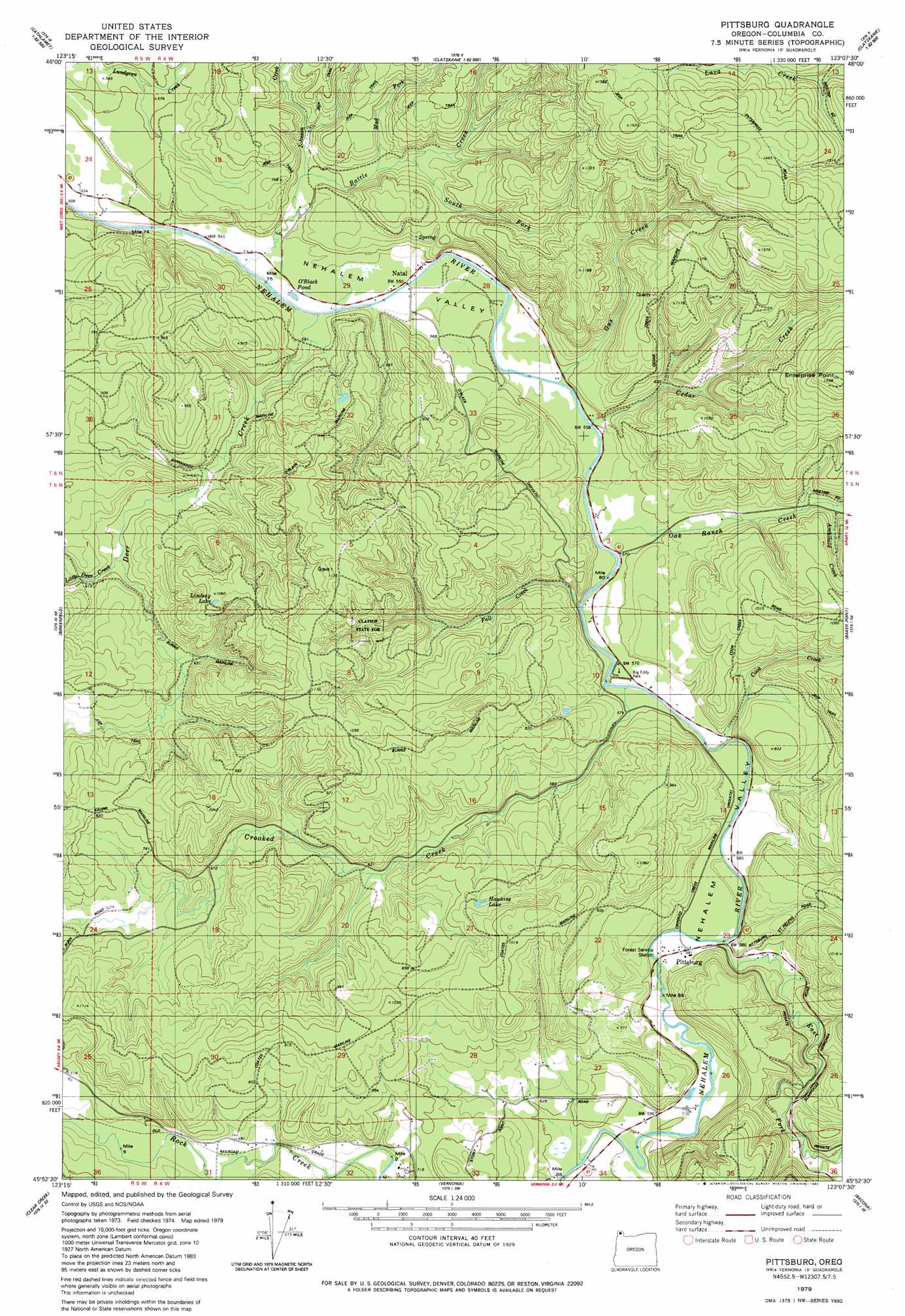
USGS Topo Quad 45123h2 - 1:24,000 scale
| Topo Map Name: | Pittsburg |
| USGS Topo Quad ID: | 45123h2 |
| Print Size: | ca. 21 1/4" wide x 27" high |
| Southeast Coordinates: | 45.875° N latitude / 123.125° W longitude |
| Map Center Coordinates: | 45.9375° N latitude / 123.1875° W longitude |
| U.S. State: | OR |
| Filename: | o45123h2.jpg |
| Download Map JPG Image: | Pittsburg topo map 1:24,000 scale |
| Map Type: | Topographic |
| Topo Series: | 7.5´ |
| Map Scale: | 1:24,000 |
| Source of Map Images: | United States Geological Survey (USGS) |
| Alternate Map Versions: |
Pittsburg OR 1979, updated 1980 Download PDF Buy paper map Pittsburg OR 2011 Download PDF Buy paper map Pittsburg OR 2014 Download PDF Buy paper map |
1:24,000 Topo Quads surrounding Pittsburg
Cathlamet |
Nassa Point |
Oak Point |
Coal Creek |
Kelso |
Nicolai Mountain |
Marshland |
Clatskanie |
Delena |
Rainier |
Sager Creek |
Birkenfeld |
Pittsburg |
Baker Point |
Trenholm |
Sunset Spring |
Clear Creek |
Vernonia |
Bacona |
Chapman |
Cochran |
Timber |
Buxton |
Meacham Corner |
Dixie Mountain |
> Back to 45123e1 at 1:100,000 scale
> Back to 45122a1 at 1:250,000 scale
> Back to U.S. Topo Maps home
Pittsburg topo map: Gazetteer
Pittsburg: Forests
Clatsop State Forest elevation 262m 859′Pittsburg: Lakes
Hawkins Lake elevation 255m 836′Lindsay Lake elevation 322m 1056′
O'Black Pond elevation 147m 482′
Pittsburg: Parks
Big Eddy Park elevation 175m 574′Pioneer Park elevation 175m 574′
Pittsburg: Populated Places
Pittsburg elevation 178m 583′Pittsburg: Post Offices
Natal Post Office (historical) elevation 162m 531′Pittsburg Post Office (historical) elevation 178m 583′
Pittsburg: Streams
Archibald Creek elevation 217m 711′Battle Creek elevation 156m 511′
Cedar Creek elevation 164m 538′
Cook Creek elevation 169m 554′
Crooked Creek elevation 168m 551′
Deer Creek elevation 159m 521′
East Fork Nehalem River elevation 175m 574′
Fall Creek elevation 167m 547′
Gus Creek elevation 164m 538′
Johnson Creek elevation 176m 577′
Little Deer Creek elevation 184m 603′
Mud Fork elevation 188m 616′
Oak Ranch Creek elevation 170m 557′
South Fork Battle Creek elevation 193m 633′
Pittsburg: Summits
Enterprise Point elevation 481m 1578′Pittsburg digital topo map on disk
Buy this Pittsburg topo map showing relief, roads, GPS coordinates and other geographical features, as a high-resolution digital map file on DVD: