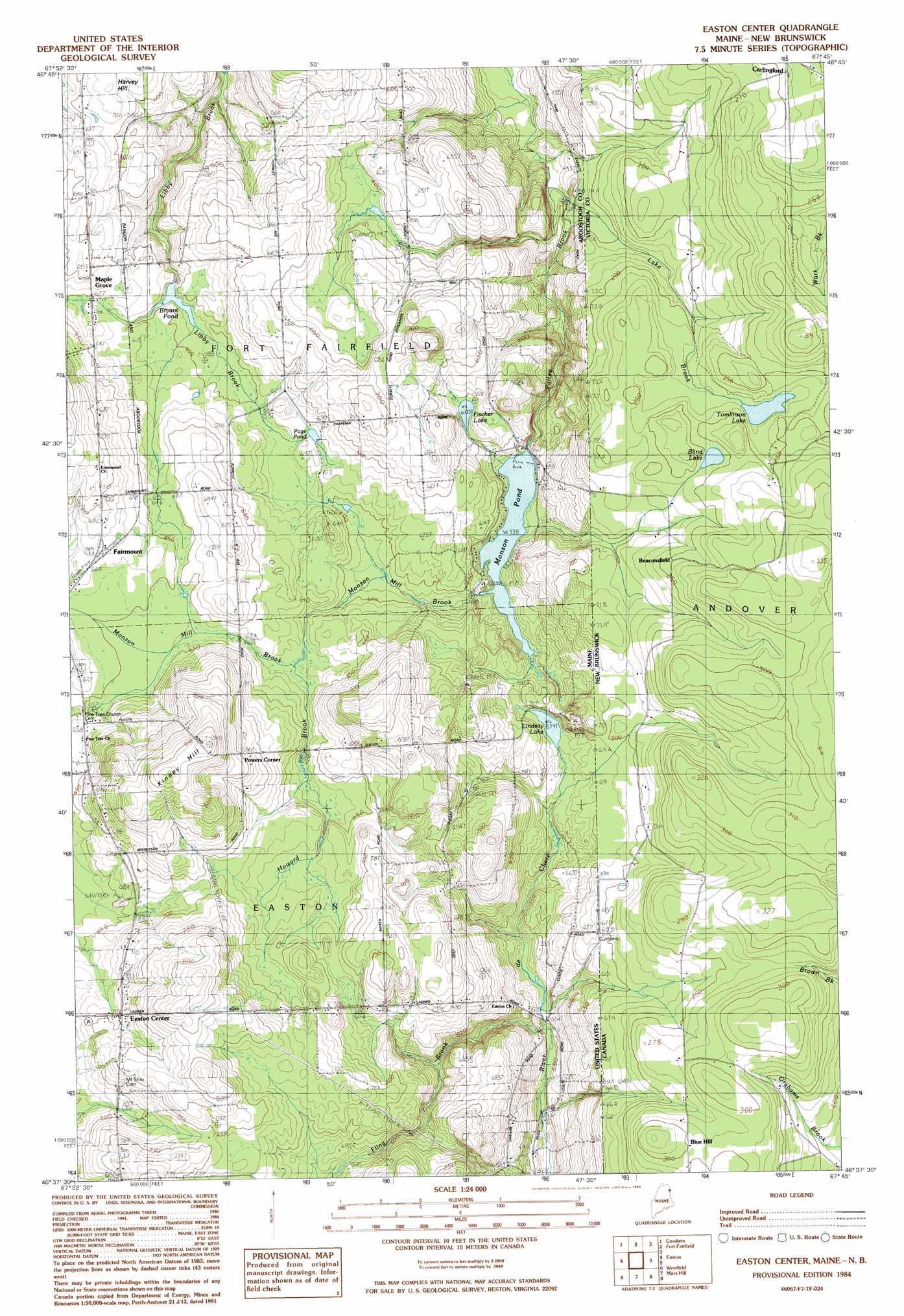
Easton Center Topo Map Maine
To zoom in, hover over the map of Easton Center
USGS Topo Quad 46067f7 - 1:24,000 scale
| Topo Map Name: | Easton Center |
| USGS Topo Quad ID: | 46067f7 |
| Print Size: | ca. 21 1/4" wide x 27" high |
| Southeast Coordinates: | 46.625° N latitude / 67.75° W longitude |
| Map Center Coordinates: | 46.6875° N latitude / 67.8125° W longitude |
| U.S. State: | ME |
| Filename: | o46067f7.jpg |
| Download Map JPG Image: | Easton Center topo map 1:24,000 scale |
| Map Type: | Topographic |
| Topo Series: | 7.5´ |
| Map Scale: | 1:24,000 |
| Source of Map Images: | United States Geological Survey (USGS) |
| Alternate Map Versions: |
Mars Hill NE ME 1975, updated 1981 Download PDF Buy paper map Mars Hill NE ME 1975, updated 1982 Download PDF Buy paper map Easton Center ME 1984, updated 1984 Download PDF Buy paper map Easton Center ME 2011 Download PDF Buy paper map Easton Center ME 2014 Download PDF Buy paper map |
1:24,000 Topo Quads surrounding Easton Center
New Sweden |
Fort Fairfield Nw |
Limestone |
||
Caribou |
Goodwin |
Fort Fairfield |
||
Presque Isle |
Easton |
Easton Center |
||
Echo Lake |
Westfield |
Mars Hill |
||
Number Nine Lake |
Packard Lake |
Bridgewater |
> Back to 46067e1 at 1:100,000 scale
> Back to 46066a1 at 1:250,000 scale
> Back to U.S. Topo Maps home
Easton Center topo map: Gazetteer
Easton Center: Dams
Bryant Pond Dam elevation 178m 583′Monson Pond Dam elevation 170m 557′
Easton Center: Lakes
Fischer Lake elevation 194m 636′Lindsay Lake elevation 175m 574′
Page Pond elevation 188m 616′
Easton Center: Populated Places
Easton Center elevation 215m 705′Fairmount elevation 205m 672′
Maple Grove elevation 183m 600′
Powers Corner elevation 225m 738′
Easton Center: Reservoirs
Bryant Pond elevation 178m 583′Monson Pond elevation 170m 557′
Easton Center: Streams
Fling Brook elevation 153m 501′Howard Brook elevation 170m 557′
Easton Center: Summits
Kinney Hill elevation 266m 872′Easton Center digital topo map on disk
Buy this Easton Center topo map showing relief, roads, GPS coordinates and other geographical features, as a high-resolution digital map file on DVD:
Maine, New Hampshire, Rhode Island & Eastern Massachusetts
Buy digital topo maps: Maine, New Hampshire, Rhode Island & Eastern Massachusetts