Fort Fairfield Nw Topo Map Maine
To zoom in, hover over the map of Fort Fairfield Nw
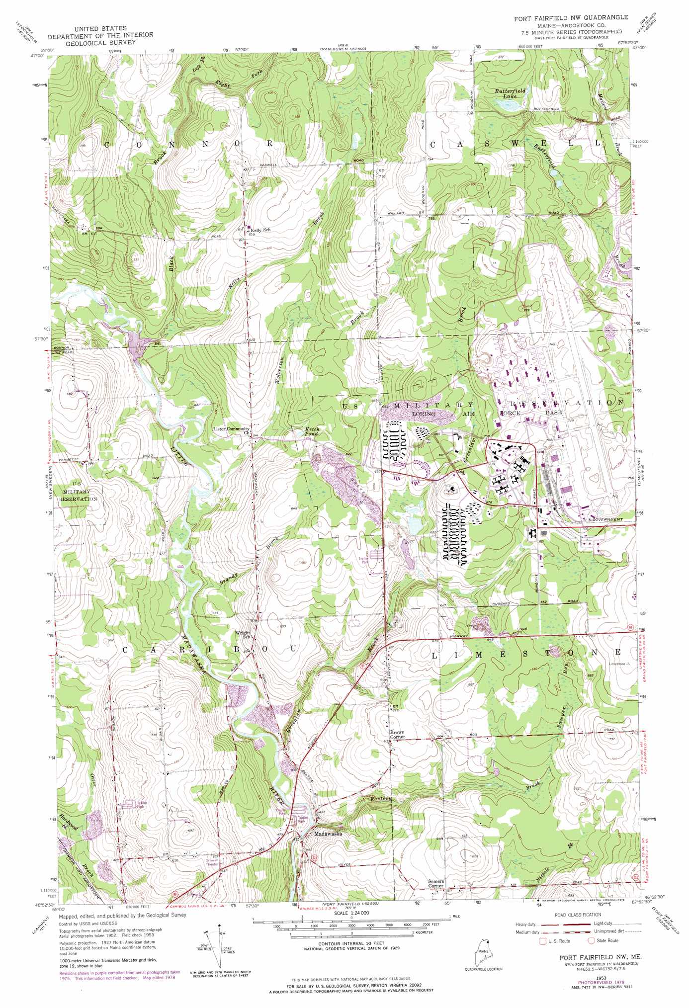
USGS Topo Quad 46067h8 - 1:24,000 scale
| Topo Map Name: | Fort Fairfield Nw |
| USGS Topo Quad ID: | 46067h8 |
| Print Size: | ca. 21 1/4" wide x 27" high |
| Southeast Coordinates: | 46.875° N latitude / 67.875° W longitude |
| Map Center Coordinates: | 46.9375° N latitude / 67.9375° W longitude |
| U.S. State: | ME |
| Filename: | o46067h8.jpg |
| Download Map JPG Image: | Fort Fairfield Nw topo map 1:24,000 scale |
| Map Type: | Topographic |
| Topo Series: | 7.5´ |
| Map Scale: | 1:24,000 |
| Source of Map Images: | United States Geological Survey (USGS) |
| Alternate Map Versions: |
Fort Fairfield NW ME 1953, updated 1955 Download PDF Buy paper map Fort Fairfield NW ME 1953, updated 1978 Download PDF Buy paper map Fort Fairfield NW ME 1975, updated 1981 Download PDF Buy paper map Fort Fairfield NW ME 2011 Download PDF Buy paper map Fort Fairfield NW ME 2014 Download PDF Buy paper map |
1:24,000 Topo Quads surrounding Fort Fairfield Nw
Paulette Brook |
Violette Stream |
Van Buren |
||
Stockholm |
Picard Brook |
Doyle Ridge |
Hamlin |
|
Mud Lake |
New Sweden |
Fort Fairfield Nw |
Limestone |
|
Washburn |
Caribou |
Goodwin |
Fort Fairfield |
|
Mapleton |
Presque Isle |
Easton |
Easton Center |
> Back to 46067e1 at 1:100,000 scale
> Back to 46066a1 at 1:250,000 scale
> Back to U.S. Topo Maps home
Fort Fairfield Nw topo map: Gazetteer
Fort Fairfield Nw: Dams
Little Madawaska Dam elevation 144m 472′Malabeam Lake Dam elevation 184m 603′
Fort Fairfield Nw: Lakes
Butterfield Lake elevation 229m 751′Ketch Pond elevation 169m 554′
Fort Fairfield Nw: Populated Places
Brown Corner elevation 187m 613′Madawaska elevation 129m 423′
Somers Corner elevation 186m 610′
Fort Fairfield Nw: Reservoirs
Little Madawaska Reservoir elevation 144m 472′Malabeam Lake elevation 184m 603′
Fort Fairfield Nw: Streams
Black Brook elevation 148m 485′Brandy Brook elevation 134m 439′
Factory Brook elevation 122m 400′
Greenlaw Brook elevation 128m 419′
Hardwood Brook elevation 133m 436′
Kelly Brook elevation 144m 472′
Left Fork Black Brook elevation 181m 593′
Masters Brook elevation 201m 659′
Right Fork Black Brook elevation 183m 600′
Wolverton Brook elevation 134m 439′
Fort Fairfield Nw digital topo map on disk
Buy this Fort Fairfield Nw topo map showing relief, roads, GPS coordinates and other geographical features, as a high-resolution digital map file on DVD:
Maine, New Hampshire, Rhode Island & Eastern Massachusetts
Buy digital topo maps: Maine, New Hampshire, Rhode Island & Eastern Massachusetts