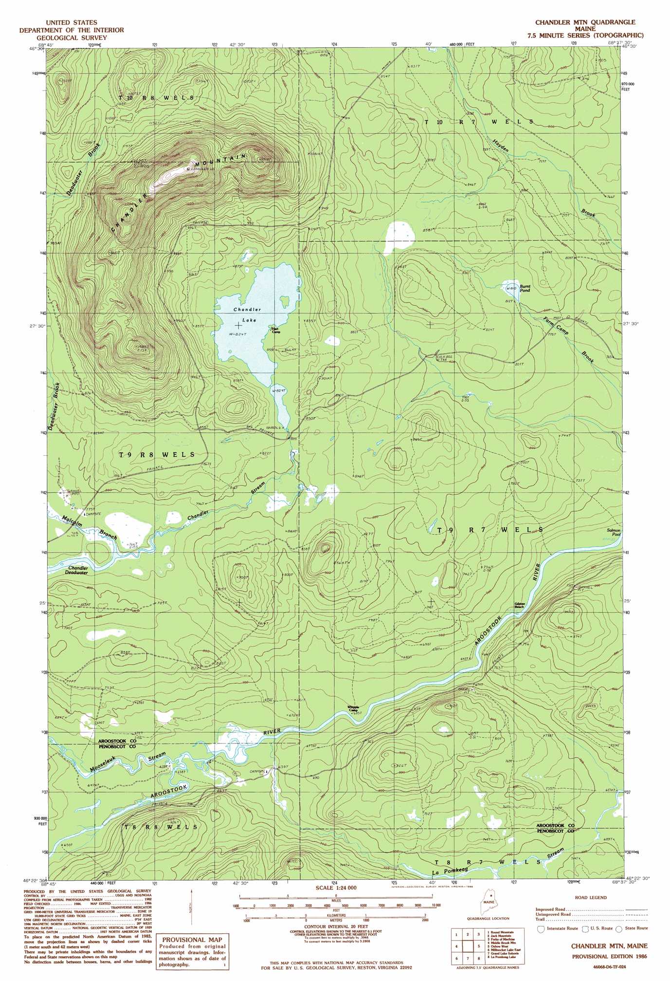
Chandler Mountain Topo Map Maine
To zoom in, hover over the map of Chandler Mountain
USGS Topo Quad 46068d6 - 1:24,000 scale
| Topo Map Name: | Chandler Mountain |
| USGS Topo Quad ID: | 46068d6 |
| Print Size: | ca. 21 1/4" wide x 27" high |
| Southeast Coordinates: | 46.375° N latitude / 68.625° W longitude |
| Map Center Coordinates: | 46.4375° N latitude / 68.6875° W longitude |
| U.S. State: | ME |
| Filename: | o46068d6.jpg |
| Download Map JPG Image: | Chandler Mountain topo map 1:24,000 scale |
| Map Type: | Topographic |
| Topo Series: | 7.5´ |
| Map Scale: | 1:24,000 |
| Source of Map Images: | United States Geological Survey (USGS) |
| Alternate Map Versions: |
Grand Lake Seboeis NW ME 1975, updated 1981 Download PDF Buy paper map Chandler Mtn ME 1986, updated 1986 Download PDF Buy paper map Chandler Mountain ME 2011 Download PDF Buy paper map Chandler Mountain ME 2014 Download PDF Buy paper map |
1:24,000 Topo Quads surrounding Chandler Mountain
Farrar Pond |
Big Machias Lake |
Greenlaw Pond |
Little Machias Lake |
Ashland |
Mooseleuk Lake |
Round Mountain |
Jack Mountain |
Forks Of Machias |
Squa Pan |
Mooseleuk Mountain |
Middle Brook Mountain |
Chandler Mountain |
Oxbow West |
Oxbow East |
Millinocket Lake West |
Millinocket Lake East |
Grand Lake Seboeis |
La Pomkeag Lake |
Umcolcus Lake |
Frost Pond |
Trout Brook Mountain |
Hay Lake |
Hay Brook Mountain |
Green Mountain |
> Back to 46068a1 at 1:100,000 scale
> Back to 46068a1 at 1:250,000 scale
> Back to U.S. Topo Maps home
Chandler Mountain topo map: Gazetteer
Chandler Mountain: Beaches
Gilman Beach elevation 193m 633′Chandler Mountain: Dams
Rock Dam elevation 251m 823′Chandler Mountain: Lakes
Burnt Pond elevation 247m 810′Chandler Deadwater elevation 230m 754′
Chandler Lake elevation 251m 823′
Salmon Pool elevation 193m 633′
Chandler Mountain: Streams
Carry Brook elevation 209m 685′LaPomkeag Stream elevation 193m 633′
Malcolm Branch elevation 230m 754′
Mooseleuk Stream elevation 194m 636′
Chandler Mountain: Summits
Chandler Mountain elevation 577m 1893′Chandler Mountain digital topo map on disk
Buy this Chandler Mountain topo map showing relief, roads, GPS coordinates and other geographical features, as a high-resolution digital map file on DVD:
Maine, New Hampshire, Rhode Island & Eastern Massachusetts
Buy digital topo maps: Maine, New Hampshire, Rhode Island & Eastern Massachusetts