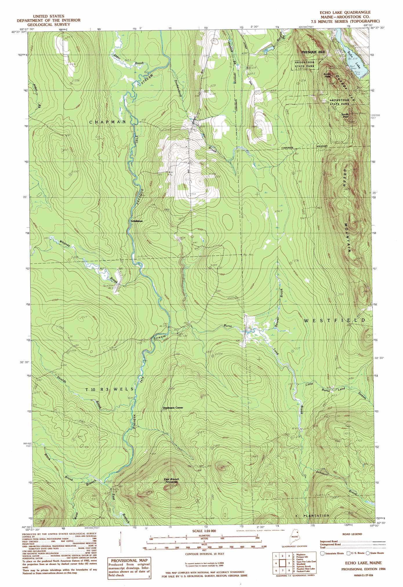
Echo Lake Topo Map Maine
To zoom in, hover over the map of Echo Lake
USGS Topo Quad 46068e1 - 1:24,000 scale
| Topo Map Name: | Echo Lake |
| USGS Topo Quad ID: | 46068e1 |
| Print Size: | ca. 21 1/4" wide x 27" high |
| Southeast Coordinates: | 46.5° N latitude / 68° W longitude |
| Map Center Coordinates: | 46.5625° N latitude / 68.0625° W longitude |
| U.S. State: | ME |
| Filename: | o46068e1.jpg |
| Download Map JPG Image: | Echo Lake topo map 1:24,000 scale |
| Map Type: | Topographic |
| Topo Series: | 7.5´ |
| Map Scale: | 1:24,000 |
| Source of Map Images: | United States Geological Survey (USGS) |
| Alternate Map Versions: |
Presque Isle SE ME 1975, updated 1981 Download PDF Buy paper map Echo Lake ME 1984, updated 1984 Download PDF Buy paper map Echo Lake ME 2011 Download PDF Buy paper map Echo Lake ME 2014 Download PDF Buy paper map |
1:24,000 Topo Quads surrounding Echo Lake
Bull Brook |
Washburn |
Caribou |
Goodwin |
Fort Fairfield |
York Ridge |
Mapleton |
Presque Isle |
Easton |
Easton Center |
Squa Pan Lake West |
Squa Pan Lake East |
Echo Lake |
Westfield |
Mars Hill |
Griswold |
Spinney Brook |
Number Nine Lake |
Packard Lake |
Bridgewater |
Mcnally Ridge |
Saint Croix Lake |
North Brook Ridge |
Harvey |
Monticello |
> Back to 46068e1 at 1:100,000 scale
> Back to 46068a1 at 1:250,000 scale
> Back to U.S. Topo Maps home
Echo Lake topo map: Gazetteer
Echo Lake: Dams
Arnold Lake Dam elevation 208m 682′Burntland Stream Dam elevation 182m 597′
East Branch Dam elevation 194m 636′
Whitney Brook Dam elevation 173m 567′
Echo Lake: Parks
Aroostook State Park elevation 298m 977′Echo Lake: Pillars
East Branch Pinnacles elevation 309m 1013′Echo Lake: Populated Places
Deadmans Corner elevation 209m 685′Grindstone elevation 152m 498′
Echo Lake: Reservoirs
Arnold Lake elevation 208m 682′Burntland Stream elevation 182m 597′
East Branch Presque Isle Stream Reservoir elevation 194m 636′
Whitney Brook elevation 173m 567′
Echo Lake: Streams
Black Brook elevation 187m 613′Burnt Land Brook elevation 162m 531′
Dockendorff Brook elevation 141m 462′
East Branch Presque Isle Stream elevation 184m 603′
Grendell Brook elevation 137m 449′
Johnson Brook elevation 195m 639′
Little Burnt Land Stream elevation 183m 600′
Shields Brook elevation 172m 564′
West Branch Presque Isle Stream elevation 185m 606′
Whitney Brook elevation 161m 528′
Echo Lake: Summits
Green Mountain elevation 385m 1263′North Peak elevation 332m 1089′
Quaggy Joe elevation 370m 1213′
South Peak elevation 370m 1213′
Echo Lake digital topo map on disk
Buy this Echo Lake topo map showing relief, roads, GPS coordinates and other geographical features, as a high-resolution digital map file on DVD:
Maine, New Hampshire, Rhode Island & Eastern Massachusetts
Buy digital topo maps: Maine, New Hampshire, Rhode Island & Eastern Massachusetts