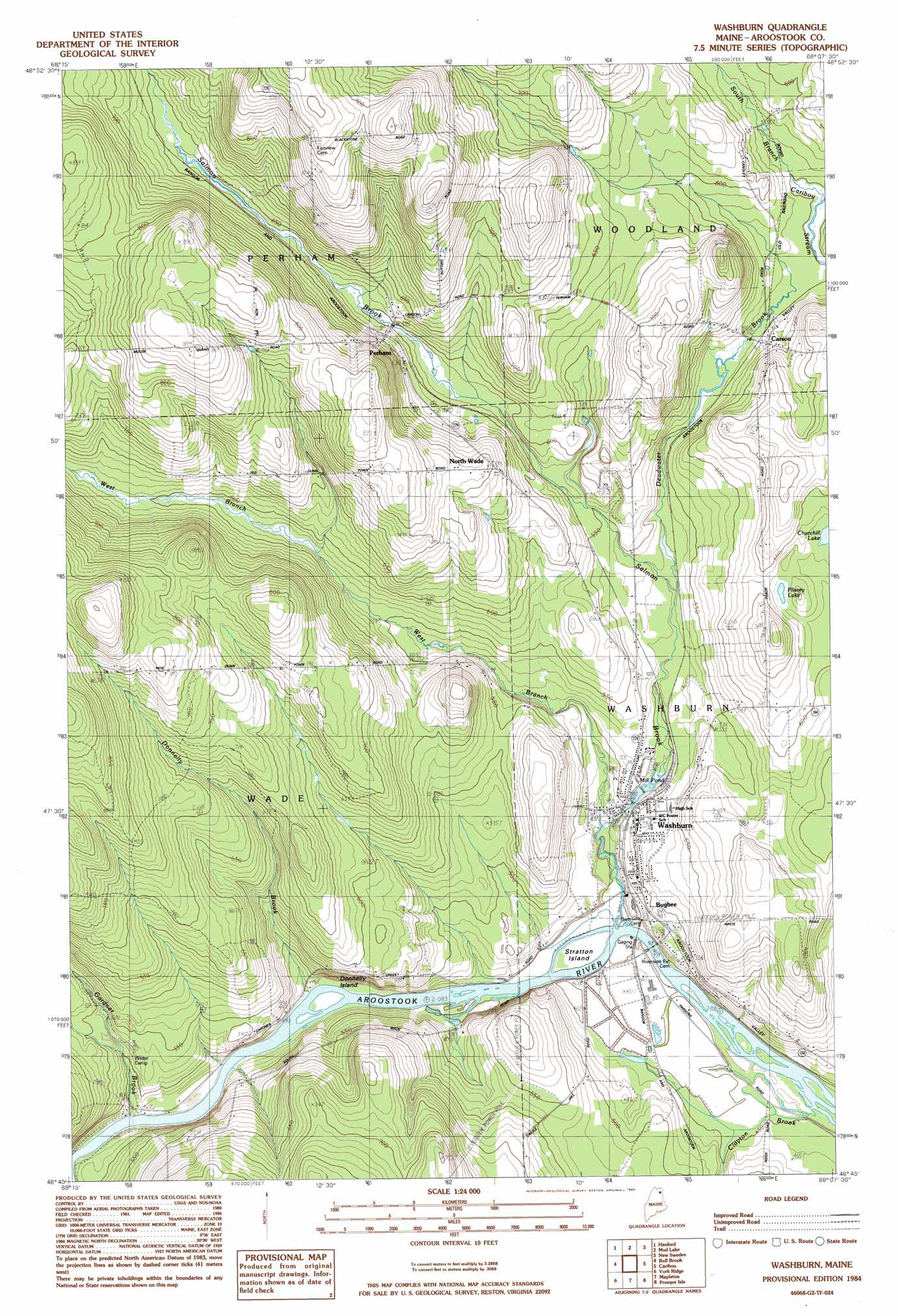
Washburn Topo Map Maine
To zoom in, hover over the map of Washburn
USGS Topo Quad 46068g2 - 1:24,000 scale
| Topo Map Name: | Washburn |
| USGS Topo Quad ID: | 46068g2 |
| Print Size: | ca. 21 1/4" wide x 27" high |
| Southeast Coordinates: | 46.75° N latitude / 68.125° W longitude |
| Map Center Coordinates: | 46.8125° N latitude / 68.1875° W longitude |
| U.S. State: | ME |
| Filename: | o46068g2.jpg |
| Download Map JPG Image: | Washburn topo map 1:24,000 scale |
| Map Type: | Topographic |
| Topo Series: | 7.5´ |
| Map Scale: | 1:24,000 |
| Source of Map Images: | United States Geological Survey (USGS) |
| Alternate Map Versions: |
Caribou SW ME 1975, updated 1981 Download PDF Buy paper map Washburn ME 1984, updated 1985 Download PDF Buy paper map Washburn ME 2011 Download PDF Buy paper map Washburn ME 2014 Download PDF Buy paper map |
1:24,000 Topo Quads surrounding Washburn
Square Lake West |
Square Lake East |
Stockholm |
Picard Brook |
Doyle Ridge |
Mcclusky Lake |
Hanford |
Mud Lake |
New Sweden |
Fort Fairfield Nw |
Portage Lake East |
Bull Brook |
Washburn |
Caribou |
Goodwin |
Ashland |
York Ridge |
Mapleton |
Presque Isle |
Easton |
Squa Pan |
Squa Pan Lake West |
Squa Pan Lake East |
Echo Lake |
Westfield |
> Back to 46068e1 at 1:100,000 scale
> Back to 46068a1 at 1:250,000 scale
> Back to U.S. Topo Maps home
Washburn topo map: Gazetteer
Washburn: Dams
Washburn Dam elevation 147m 482′Washburn: Islands
Donnelly Island elevation 137m 449′Stratton Island elevation 136m 446′
Washburn: Lakes
Churchill Lake elevation 190m 623′Plissey Lake elevation 191m 626′
Washburn: Populated Places
Bugbee elevation 147m 482′Carson elevation 175m 574′
North Wade elevation 213m 698′
Perham elevation 199m 652′
Washburn elevation 148m 485′
Washburn: Reservoirs
Mill Pond elevation 147m 482′Washburn Community Pond elevation 153m 501′
Washburn: Streams
Deadwater Brook elevation 158m 518′Donnelly Brook elevation 137m 449′
Factory Brook elevation 175m 574′
Gardner Brook elevation 137m 449′
Salmon Brook elevation 131m 429′
West Branch Salmon Brook elevation 137m 449′
Washburn digital topo map on disk
Buy this Washburn topo map showing relief, roads, GPS coordinates and other geographical features, as a high-resolution digital map file on DVD:
Maine, New Hampshire, Rhode Island & Eastern Massachusetts
Buy digital topo maps: Maine, New Hampshire, Rhode Island & Eastern Massachusetts