Portage Lake East Topo Map Maine
To zoom in, hover over the map of Portage Lake East
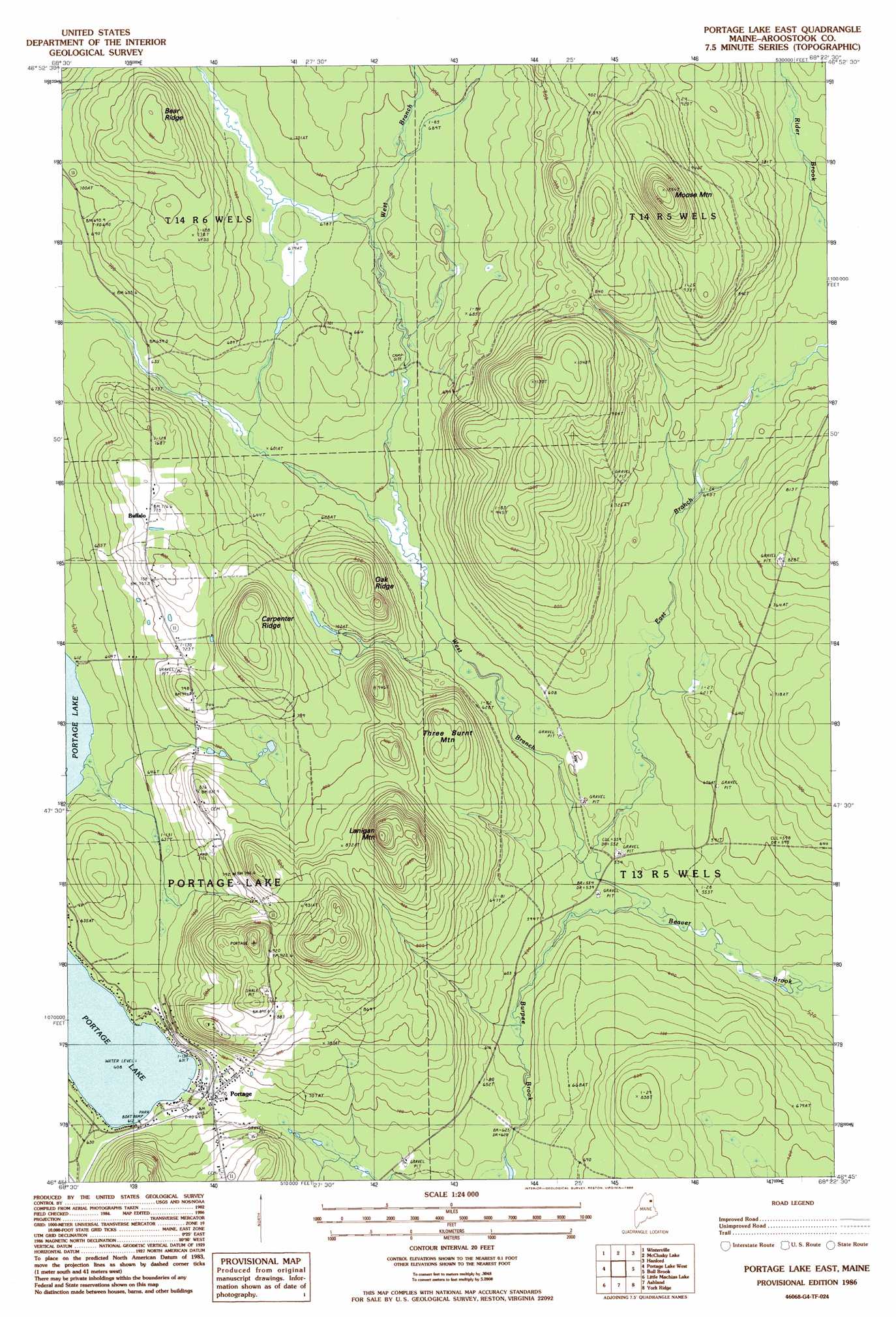
USGS Topo Quad 46068g4 - 1:24,000 scale
| Topo Map Name: | Portage Lake East |
| USGS Topo Quad ID: | 46068g4 |
| Print Size: | ca. 21 1/4" wide x 27" high |
| Southeast Coordinates: | 46.75° N latitude / 68.375° W longitude |
| Map Center Coordinates: | 46.8125° N latitude / 68.4375° W longitude |
| U.S. State: | ME |
| Filename: | o46068g4.jpg |
| Download Map JPG Image: | Portage Lake East topo map 1:24,000 scale |
| Map Type: | Topographic |
| Topo Series: | 7.5´ |
| Map Scale: | 1:24,000 |
| Source of Map Images: | United States Geological Survey (USGS) |
| Alternate Map Versions: |
Portage SW ME 1975, updated 1981 Download PDF Buy paper map Portage Lake East ME 1986, updated 1986 Download PDF Buy paper map Portage Lake East ME 2011 Download PDF Buy paper map Portage Lake East ME 2014 Download PDF Buy paper map |
1:24,000 Topo Quads surrounding Portage Lake East
Wallacrass Lakes |
Eagle Lake |
Square Lake West |
Square Lake East |
Stockholm |
Island Pond |
Winterville |
Mcclusky Lake |
Hanford |
Mud Lake |
Carr Pond |
Portage Lake West |
Portage Lake East |
Bull Brook |
Washburn |
Greenlaw Pond |
Little Machias Lake |
Ashland |
York Ridge |
Mapleton |
Jack Mountain |
Forks Of Machias |
Squa Pan |
Squa Pan Lake West |
Squa Pan Lake East |
> Back to 46068e1 at 1:100,000 scale
> Back to 46068a1 at 1:250,000 scale
> Back to U.S. Topo Maps home
Portage Lake East topo map: Gazetteer
Portage Lake East: Airports
Allen Saint Peter Memorial Airport elevation 252m 826′Portage Lake Municipal Seaplane Base elevation 187m 613′
Portage Lake East: Populated Places
Buffalo elevation 234m 767′Portage elevation 198m 649′
Portage Lake East: Post Offices
Portage Post Office elevation 198m 649′Portage Lake East: Ridges
Bear Ridge elevation 278m 912′Carpenter Ridge elevation 282m 925′
Oak Ridge elevation 260m 853′
Portage Lake East: Streams
Burpee Brook elevation 166m 544′East Branch Beaver Brook elevation 165m 541′
West Branch Beaver Brook elevation 165m 541′
Portage Lake East: Summits
Lanigan Mountain elevation 363m 1190′Moose Mountain elevation 381m 1250′
Three Burnt Mountain elevation 255m 836′
Portage Lake East digital topo map on disk
Buy this Portage Lake East topo map showing relief, roads, GPS coordinates and other geographical features, as a high-resolution digital map file on DVD:
Maine, New Hampshire, Rhode Island & Eastern Massachusetts
Buy digital topo maps: Maine, New Hampshire, Rhode Island & Eastern Massachusetts