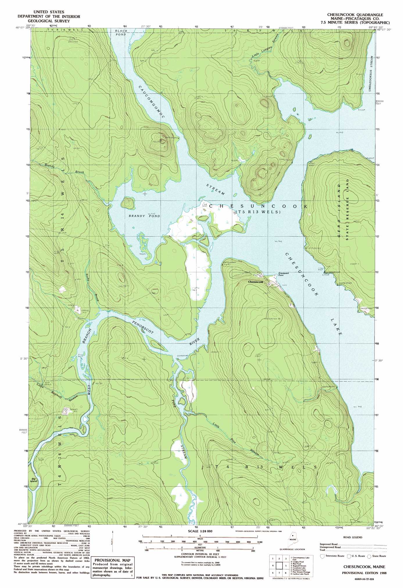
Chesuncook Topo Map Maine
To zoom in, hover over the map of Chesuncook
USGS Topo Quad 46069a4 - 1:24,000 scale
| Topo Map Name: | Chesuncook |
| USGS Topo Quad ID: | 46069a4 |
| Print Size: | ca. 21 1/4" wide x 27" high |
| Southeast Coordinates: | 46° N latitude / 69.375° W longitude |
| Map Center Coordinates: | 46.0625° N latitude / 69.4375° W longitude |
| U.S. State: | ME |
| Filename: | o46069a4.jpg |
| Download Map JPG Image: | Chesuncook topo map 1:24,000 scale |
| Map Type: | Topographic |
| Topo Series: | 7.5´ |
| Map Scale: | 1:24,000 |
| Source of Map Images: | United States Geological Survey (USGS) |
| Alternate Map Versions: |
Chesuncook ME 1988, updated 1988 Download PDF Buy paper map Chesuncook ME 2011 Download PDF Buy paper map Chesuncook ME 2014 Download PDF Buy paper map |
1:24,000 Topo Quads surrounding Chesuncook
Wadleigh Pond |
Allagash Lake |
Tramway |
Soper Mountain |
Haymock Lake |
Caucomgomoc Lake West |
Caucomgomoc Lake East |
Longley Pond |
Mud Pond |
Telos Lake |
Bean Pot Pond |
Ragmuff Stream |
Chesuncook |
Cuxabexis Lake |
Telos Brook |
Seboomook |
Penobscot Farm |
Pine Stream Flowage |
Caribou Lake North |
Harrington Lake |
North East Carry |
Lobster Mountain |
Big Spencer Mountain |
Caribou Lake South |
Rainbow Lake West |
> Back to 46069a1 at 1:100,000 scale
> Back to 46068a1 at 1:250,000 scale
> Back to U.S. Topo Maps home
Chesuncook topo map: Gazetteer
Chesuncook: Capes
Graveyard Point elevation 287m 941′Chesuncook: Islands
Big Island elevation 297m 974′Gero Island elevation 327m 1072′
Chesuncook: Lakes
Brandy Pond elevation 287m 941′Chesuncook: Populated Places
Chesuncook elevation 291m 954′Chesuncook: Streams
Brandy Brook elevation 287m 941′Caucomgomoc Stream elevation 287m 941′
Little Longley Stream elevation 287m 941′
Little Pine Stream elevation 288m 944′
Little Ragmuff Stream elevation 289m 948′
Pine Stream elevation 288m 944′
Rocky Brook elevation 288m 944′
Umbazooksus Stream elevation 287m 941′
Chesuncook digital topo map on disk
Buy this Chesuncook topo map showing relief, roads, GPS coordinates and other geographical features, as a high-resolution digital map file on DVD:
Maine, New Hampshire, Rhode Island & Eastern Massachusetts
Buy digital topo maps: Maine, New Hampshire, Rhode Island & Eastern Massachusetts