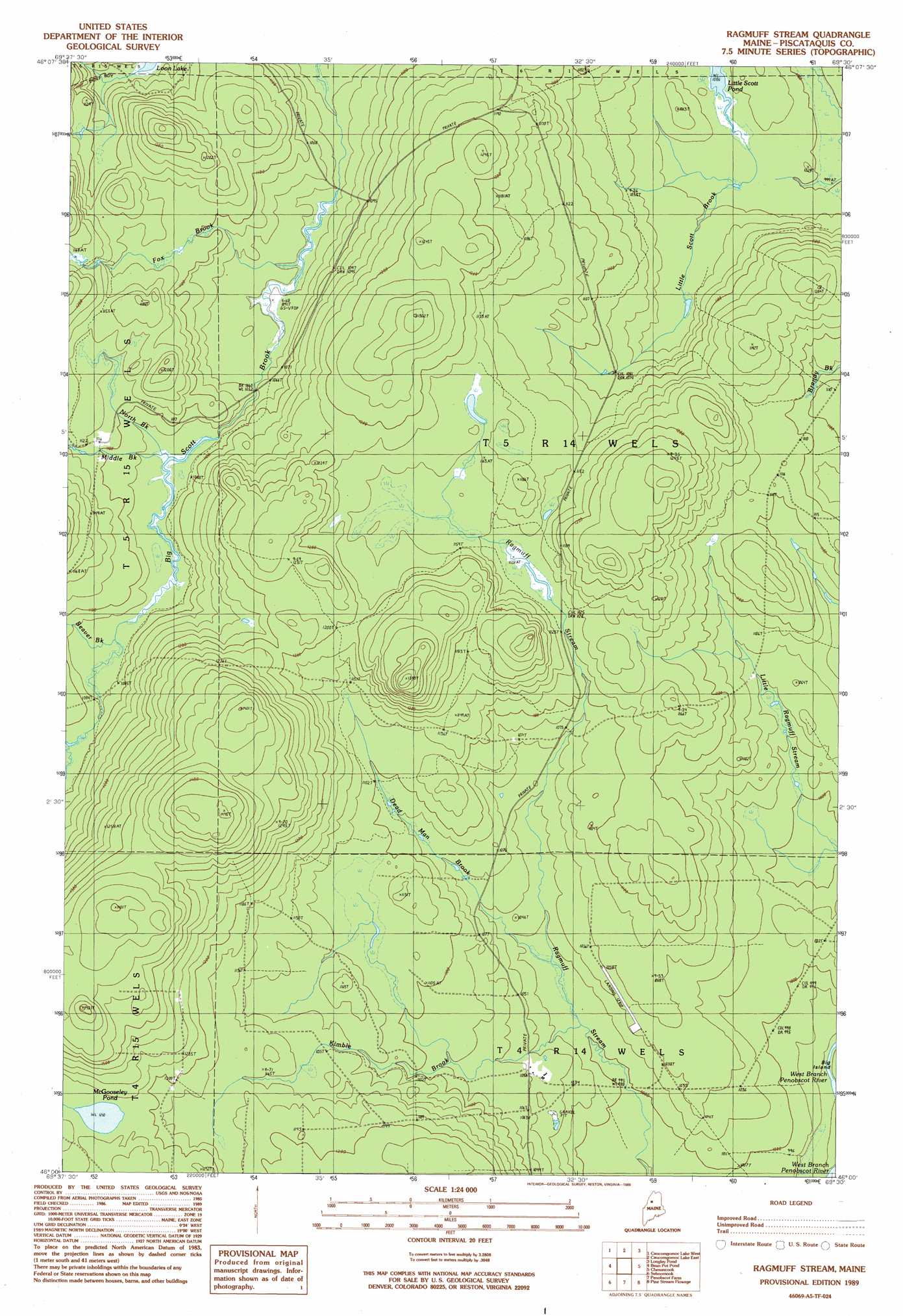
Ragmuff Stream Topo Map Maine
To zoom in, hover over the map of Ragmuff Stream
USGS Topo Quad 46069a5 - 1:24,000 scale
| Topo Map Name: | Ragmuff Stream |
| USGS Topo Quad ID: | 46069a5 |
| Print Size: | ca. 21 1/4" wide x 27" high |
| Southeast Coordinates: | 46° N latitude / 69.5° W longitude |
| Map Center Coordinates: | 46.0625° N latitude / 69.5625° W longitude |
| U.S. State: | ME |
| Filename: | o46069a5.jpg |
| Download Map JPG Image: | Ragmuff Stream topo map 1:24,000 scale |
| Map Type: | Topographic |
| Topo Series: | 7.5´ |
| Map Scale: | 1:24,000 |
| Source of Map Images: | United States Geological Survey (USGS) |
| Alternate Map Versions: |
Ragmuff Stream ME 1989, updated 1989 Download PDF Buy paper map Ragmuff Stream ME 2011 Download PDF Buy paper map Ragmuff Stream ME 2014 Download PDF Buy paper map |
1:24,000 Topo Quads surrounding Ragmuff Stream
Turner Pond |
Wadleigh Pond |
Allagash Lake |
Tramway |
Soper Mountain |
Spruce Brook |
Caucomgomoc Lake West |
Caucomgomoc Lake East |
Longley Pond |
Mud Pond |
Russell Mountain |
Bean Pot Pond |
Ragmuff Stream |
Chesuncook |
Cuxabexis Lake |
Seboomook Lake East |
Seboomook |
Penobscot Farm |
Pine Stream Flowage |
Caribou Lake North |
Socatean Bay |
North East Carry |
Lobster Mountain |
Big Spencer Mountain |
Caribou Lake South |
> Back to 46069a1 at 1:100,000 scale
> Back to 46068a1 at 1:250,000 scale
> Back to U.S. Topo Maps home
Ragmuff Stream topo map: Gazetteer
Ragmuff Stream: Lakes
Little Scott Pond elevation 306m 1003′McGooseley Pond elevation 369m 1210′
Ragmuff Stream: Streams
Beaver Brook elevation 329m 1079′Dead Man Brook elevation 309m 1013′
Fox Brook elevation 316m 1036′
Kimble Brook elevation 307m 1007′
Middle Brook elevation 328m 1076′
North Brook elevation 327m 1072′
Ragmuff Stream digital topo map on disk
Buy this Ragmuff Stream topo map showing relief, roads, GPS coordinates and other geographical features, as a high-resolution digital map file on DVD:
Maine, New Hampshire, Rhode Island & Eastern Massachusetts
Buy digital topo maps: Maine, New Hampshire, Rhode Island & Eastern Massachusetts