Saint John Pond Depot Topo Map Maine
To zoom in, hover over the map of Saint John Pond Depot
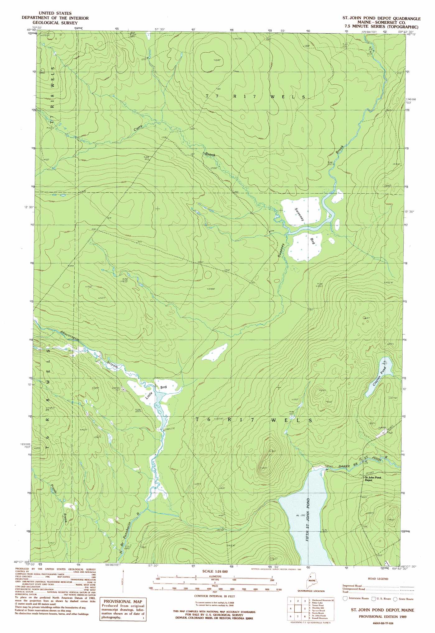
USGS Topo Quad 46069b8 - 1:24,000 scale
| Topo Map Name: | Saint John Pond Depot |
| USGS Topo Quad ID: | 46069b8 |
| Print Size: | ca. 21 1/4" wide x 27" high |
| Southeast Coordinates: | 46.125° N latitude / 69.875° W longitude |
| Map Center Coordinates: | 46.1875° N latitude / 69.9375° W longitude |
| U.S. State: | ME |
| Filename: | o46069b8.jpg |
| Download Map JPG Image: | Saint John Pond Depot topo map 1:24,000 scale |
| Map Type: | Topographic |
| Topo Series: | 7.5´ |
| Map Scale: | 1:24,000 |
| Source of Map Images: | United States Geological Survey (USGS) |
| Alternate Map Versions: |
St. John Ponds Depot ME 1989, updated 1989 Download PDF Buy paper map Saint John Pond Depot ME 2011 Download PDF Buy paper map Saint John Pond Depot ME 2014 Download PDF Buy paper map |
1:24,000 Topo Quads surrounding Saint John Pond Depot
Hardwood Mountain |
Baker Lake Nw |
Doucie Brook |
Allagash Pond |
|
Hardwood Mountain Sw |
Hardwood Mountain Se |
Baker Lake |
Turner Pond |
Wadleigh Pond |
Black Brook |
Hinckley Hill |
Saint John Pond Depot |
Spruce Brook |
Caucomgomoc Lake West |
Hurricane Hill |
Norris Brook |
Saint John Ponds |
Russell Mountain |
Bean Pot Pond |
Penobscot Lake |
Foley Pond |
Seboomook Lake West |
Seboomook Lake East |
Seboomook |
> Back to 46069a1 at 1:100,000 scale
> Back to 46068a1 at 1:250,000 scale
> Back to U.S. Topo Maps home
Saint John Pond Depot topo map: Gazetteer
Saint John Pond Depot: Dams
Lower Dam elevation 393m 1289′Upper Dam elevation 394m 1292′
Saint John Pond Depot: Lakes
Clayton Pond elevation 445m 1459′Saint John Pond Depot: Reservoirs
Fifth Saint John Pond elevation 426m 1397′Saint John Pond Depot: Streams
Abacotnetic Stream elevation 394m 1292′Carry Brook elevation 395m 1295′
Saint John Pond Depot: Swamps
Little Bog elevation 393m 1289′Sweeney Bog elevation 395m 1295′
Saint John Pond Depot digital topo map on disk
Buy this Saint John Pond Depot topo map showing relief, roads, GPS coordinates and other geographical features, as a high-resolution digital map file on DVD:
Maine, New Hampshire, Rhode Island & Eastern Massachusetts
Buy digital topo maps: Maine, New Hampshire, Rhode Island & Eastern Massachusetts