Allagash Lake Topo Map Maine
To zoom in, hover over the map of Allagash Lake
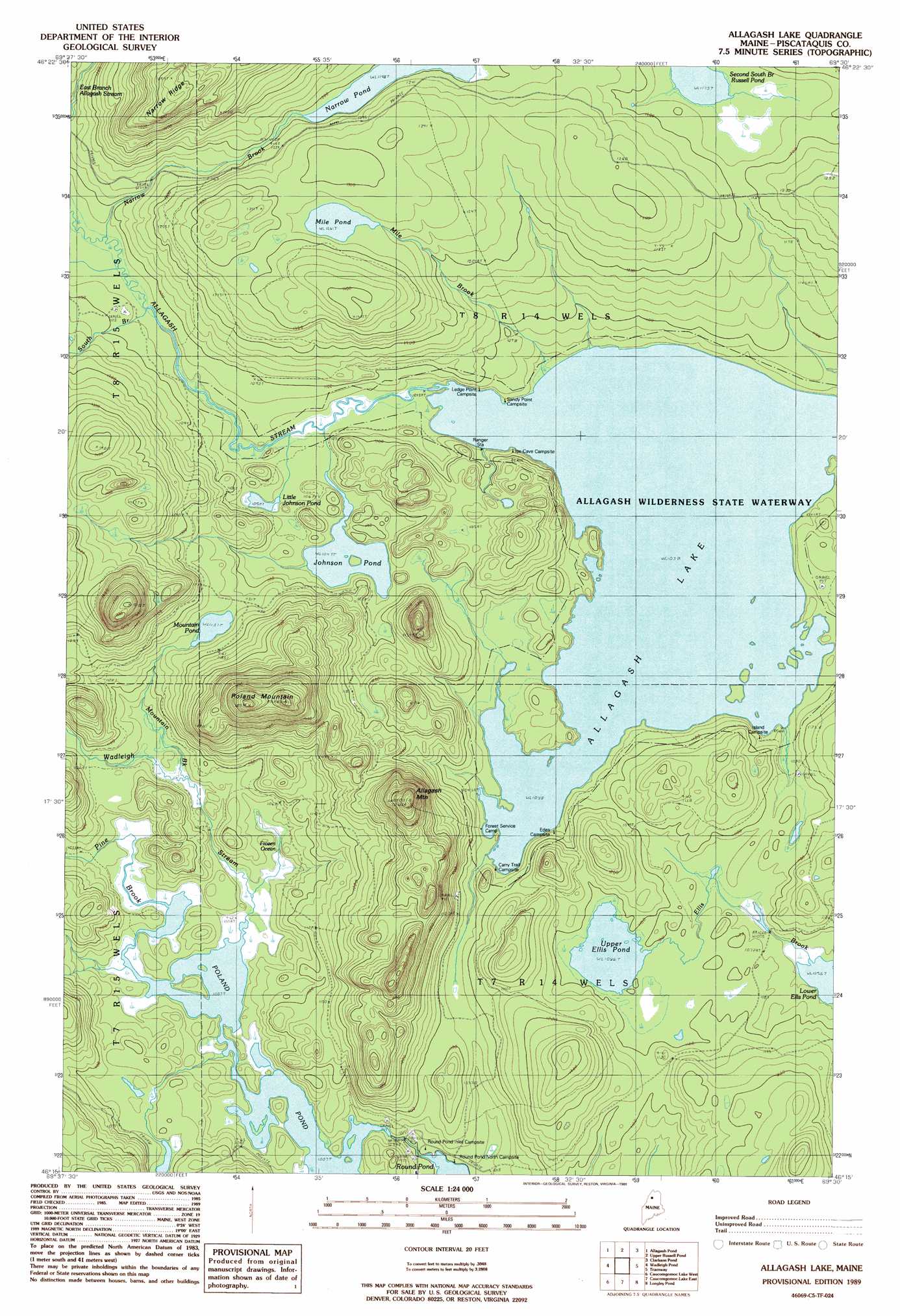
USGS Topo Quad 46069c5 - 1:24,000 scale
| Topo Map Name: | Allagash Lake |
| USGS Topo Quad ID: | 46069c5 |
| Print Size: | ca. 21 1/4" wide x 27" high |
| Southeast Coordinates: | 46.25° N latitude / 69.5° W longitude |
| Map Center Coordinates: | 46.3125° N latitude / 69.5625° W longitude |
| U.S. State: | ME |
| Filename: | o46069c5.jpg |
| Download Map JPG Image: | Allagash Lake topo map 1:24,000 scale |
| Map Type: | Topographic |
| Topo Series: | 7.5´ |
| Map Scale: | 1:24,000 |
| Source of Map Images: | United States Geological Survey (USGS) |
| Alternate Map Versions: |
Allagash Lake ME 1989, updated 1989 Download PDF Buy paper map Allagash Lake ME 1989, updated 1989 Download PDF Buy paper map Allagash Lake ME 2011 Download PDF Buy paper map Allagash Lake ME 2014 Download PDF Buy paper map |
1:24,000 Topo Quads surrounding Allagash Lake
Beaver Pond Se |
Fool Brook |
Clayton Lake |
Umaskis Lake West |
Umaskis Lake East |
Doucie Brook |
Allagash Pond |
Upper Russell Pond |
Clarkson Pond |
Churchill Lake |
Turner Pond |
Wadleigh Pond |
Allagash Lake |
Tramway |
Soper Mountain |
Spruce Brook |
Caucomgomoc Lake West |
Caucomgomoc Lake East |
Longley Pond |
Mud Pond |
Russell Mountain |
Bean Pot Pond |
Ragmuff Stream |
Chesuncook |
Cuxabexis Lake |
> Back to 46069a1 at 1:100,000 scale
> Back to 46068a1 at 1:250,000 scale
> Back to U.S. Topo Maps home
Allagash Lake topo map: Gazetteer
Allagash Lake: Lakes
Allagash Lake elevation 316m 1036′Frozen Ocean elevation 315m 1033′
Johnson Pond elevation 319m 1046′
Little Johnson Pond elevation 322m 1056′
Lower Ellis Pond elevation 322m 1056′
Mile Pond elevation 384m 1259′
Mountain Pond elevation 346m 1135′
Narrow Pond elevation 365m 1197′
Poland Pond elevation 312m 1023′
Upper Ellis Pond elevation 331m 1085′
Allagash Lake: Ridges
Narrow Ridge elevation 502m 1646′Allagash Lake: Streams
Mile Brook elevation 316m 1036′Mountain Brook elevation 316m 1036′
Narrow Brook elevation 327m 1072′
Pine Brook elevation 307m 1007′
South Branch Allagash Stream elevation 328m 1076′
Wadleigh Stream elevation 307m 1007′
Allagash Lake: Summits
Allagash Mountain elevation 537m 1761′Poland Mountain elevation 555m 1820′
Allagash Lake digital topo map on disk
Buy this Allagash Lake topo map showing relief, roads, GPS coordinates and other geographical features, as a high-resolution digital map file on DVD:
Maine, New Hampshire, Rhode Island & Eastern Massachusetts
Buy digital topo maps: Maine, New Hampshire, Rhode Island & Eastern Massachusetts