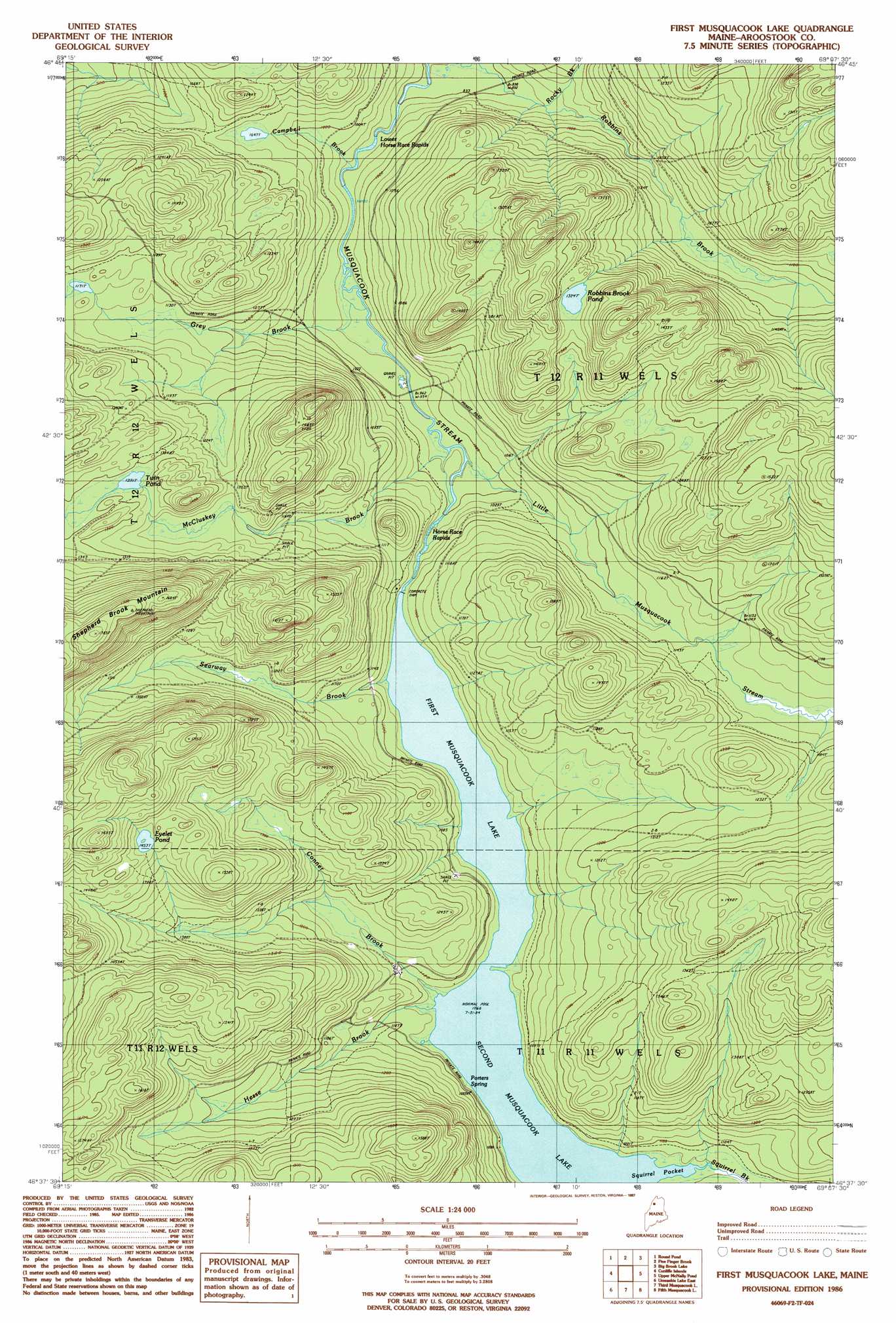
First Musquacook Lake Topo Map Maine
To zoom in, hover over the map of First Musquacook Lake
USGS Topo Quad 46069f2 - 1:24,000 scale
| Topo Map Name: | First Musquacook Lake |
| USGS Topo Quad ID: | 46069f2 |
| Print Size: | ca. 21 1/4" wide x 27" high |
| Southeast Coordinates: | 46.625° N latitude / 69.125° W longitude |
| Map Center Coordinates: | 46.6875° N latitude / 69.1875° W longitude |
| U.S. State: | ME |
| Filename: | o46069f2.jpg |
| Download Map JPG Image: | First Musquacook Lake topo map 1:24,000 scale |
| Map Type: | Topographic |
| Topo Series: | 7.5´ |
| Map Scale: | 1:24,000 |
| Source of Map Images: | United States Geological Survey (USGS) |
| Alternate Map Versions: |
First Musquacook Lake ME 1986, updated 1987 Download PDF Buy paper map First Musquacook Lake ME 2011 Download PDF Buy paper map First Musquacook Lake ME 2014 Download PDF Buy paper map |
1:24,000 Topo Quads surrounding First Musquacook Lake
Big Black Rapids |
Mckinnon Brook |
Allagash Falls |
Mckeen Lake |
Gardner Pond |
Blue Brook |
Round Pond |
Five Finger Brook |
Big Brook Lake |
Fish River Lake Sw |
Cunliffe Lake |
Cunliffe Islands |
First Musquacook Lake |
Upper Mcnally Pond |
Farrar Pond |
Umaskis Lake West |
Umaskis Lake East |
Third Musquacook Lake |
Fifth Musquacook Lake |
Mooseleuk Lake |
Clarkson Pond |
Churchill Lake |
Spider Lake |
Chase Lake |
Mooseleuk Mountain |
> Back to 46069e1 at 1:100,000 scale
> Back to 46068a1 at 1:250,000 scale
> Back to U.S. Topo Maps home
First Musquacook Lake topo map: Gazetteer
First Musquacook Lake: Bays
Squirrel Pocket elevation 325m 1066′First Musquacook Lake: Lakes
Eyelet Pond elevation 443m 1453′Robbins Brook Pond elevation 403m 1322′
Second Musquacook Lake elevation 325m 1066′
Twin Pond elevation 393m 1289′
First Musquacook Lake: Rapids
Horse Race Rapids elevation 306m 1003′Lower Horse Race Rapids elevation 284m 931′
First Musquacook Lake: Reservoirs
First Musquacook Lake elevation 329m 1079′First Musquacook Lake: Springs
Porters Spring elevation 361m 1184′First Musquacook Lake: Streams
Campbell Brook elevation 286m 938′Conner Brook elevation 326m 1069′
Grey Brook elevation 293m 961′
Hesse Brook elevation 327m 1072′
Little Musquacook Stream elevation 299m 980′
McCluskey Brook elevation 296m 971′
Robbins Brook elevation 283m 928′
Searway Brook elevation 325m 1066′
Squirrel Brook elevation 329m 1079′
First Musquacook Lake: Summits
Shepherd Brook Mountain elevation 543m 1781′First Musquacook Lake digital topo map on disk
Buy this First Musquacook Lake topo map showing relief, roads, GPS coordinates and other geographical features, as a high-resolution digital map file on DVD:
Maine, New Hampshire, Rhode Island & Eastern Massachusetts
Buy digital topo maps: Maine, New Hampshire, Rhode Island & Eastern Massachusetts