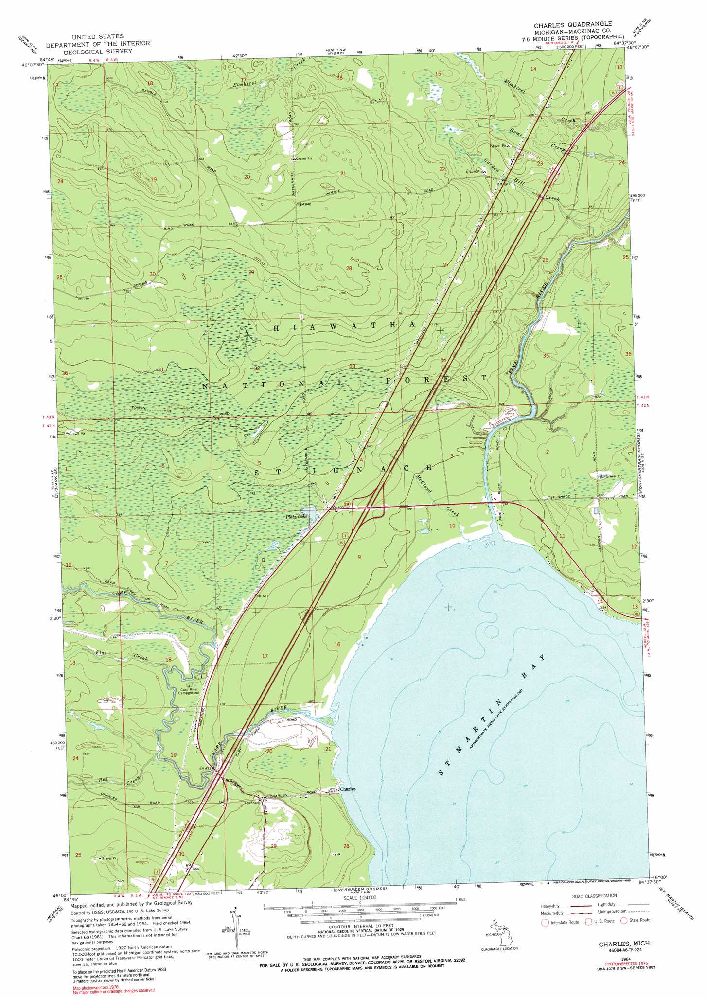
Charles Topo Map Michigan
To zoom in, hover over the map of Charles
USGS Topo Quad 46084a6 - 1:24,000 scale
| Topo Map Name: | Charles |
| USGS Topo Quad ID: | 46084a6 |
| Print Size: | ca. 21 1/4" wide x 27" high |
| Southeast Coordinates: | 46° N latitude / 84.625° W longitude |
| Map Center Coordinates: | 46.0625° N latitude / 84.6875° W longitude |
| U.S. State: | MI |
| Filename: | o46084a6.jpg |
| Download Map JPG Image: | Charles topo map 1:24,000 scale |
| Map Type: | Topographic |
| Topo Series: | 7.5´ |
| Map Scale: | 1:24,000 |
| Source of Map Images: | United States Geological Survey (USGS) |
| Alternate Map Versions: |
Charles MI 1964, updated 1966 Download PDF Buy paper map Charles MI 1964, updated 1989 Download PDF Buy paper map Charles MI 2011 Download PDF Buy paper map Charles MI 2014 Download PDF Buy paper map Charles MI 2017 Download PDF Buy paper map |
| FStopo: | US Forest Service topo Charles is available: Download FStopo PDF Download FStopo TIF |
1:24,000 Topo Quads surrounding Charles
Strongs |
Sullivan Creek |
Raco |
Kinross |
Dafter |
Ozark |
Ozark Ne |
Fibre |
Rudyard |
Pickford Nw |
Kenneth |
Ozark Se |
Charles |
Pontchartrain Shores |
Hessel |
Pnte Aux Chenes |
Moran |
Evergreen Shores |
Saint Martin Island |
Goose Island |
Big Stone Bay |
Mcgulpin Point |
Saint Ignace |
Round Island |
Mcrae Bay |
> Back to 46084a1 at 1:100,000 scale
> Back to 46084a1 at 1:250,000 scale
> Back to U.S. Topo Maps home
Charles topo map: Gazetteer
Charles: Crossings
Interchange 359 elevation 192m 629′Charles: Lakes
Platz Lake elevation 190m 623′Charles: Populated Places
Charles elevation 181m 593′Charles: Post Offices
Charles Post Office (historical) elevation 181m 593′Charles: Streams
Carp River elevation 177m 580′Flat Creek elevation 187m 613′
Garden Hill Creek elevation 180m 590′
McCloud Creek elevation 177m 580′
Pine River elevation 177m 580′
Red Creek elevation 190m 623′
Charles digital topo map on disk
Buy this Charles topo map showing relief, roads, GPS coordinates and other geographical features, as a high-resolution digital map file on DVD: