Big Beaver Creek Topo Map Michigan
To zoom in, hover over the map of Big Beaver Creek
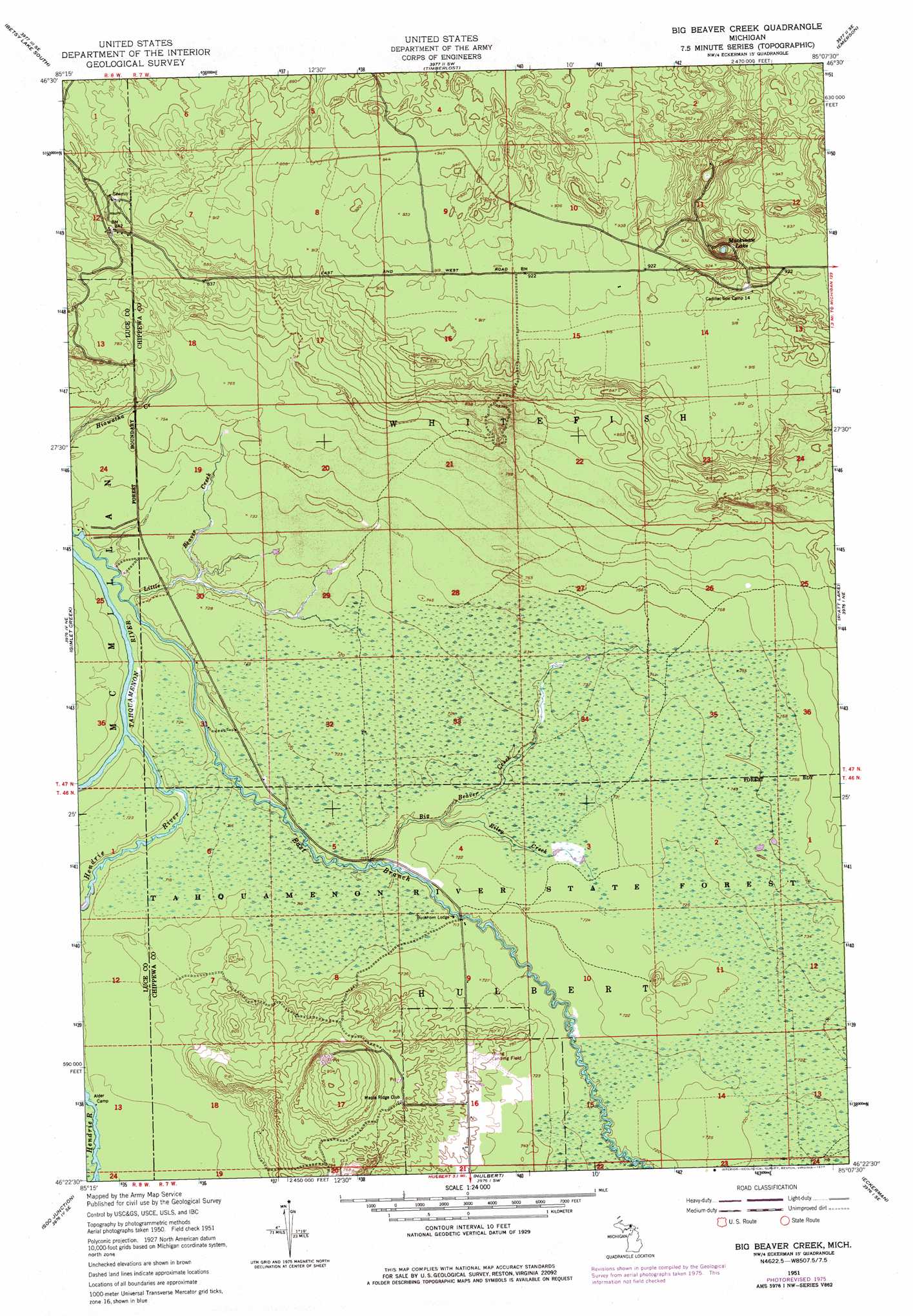
USGS Topo Quad 46085d2 - 1:24,000 scale
| Topo Map Name: | Big Beaver Creek |
| USGS Topo Quad ID: | 46085d2 |
| Print Size: | ca. 21 1/4" wide x 27" high |
| Southeast Coordinates: | 46.375° N latitude / 85.125° W longitude |
| Map Center Coordinates: | 46.4375° N latitude / 85.1875° W longitude |
| U.S. State: | MI |
| Filename: | o46085d2.jpg |
| Download Map JPG Image: | Big Beaver Creek topo map 1:24,000 scale |
| Map Type: | Topographic |
| Topo Series: | 7.5´ |
| Map Scale: | 1:24,000 |
| Source of Map Images: | United States Geological Survey (USGS) |
| Alternate Map Versions: |
Big Beaver Creek MI 1951, updated 1955 Download PDF Buy paper map Big Beaver Creek MI 1951, updated 1974 Download PDF Buy paper map Big Beaver Creek MI 1951, updated 1977 Download PDF Buy paper map Big Beaver Creek MI 2011 Download PDF Buy paper map Big Beaver Creek MI 2014 Download PDF Buy paper map Big Beaver Creek MI 2017 Download PDF Buy paper map |
1:24,000 Topo Quads surrounding Big Beaver Creek
Betsy Lake Nw |
Betsy Lake North |
Sheephead Lake |
Shelldrake |
Whitefish Point |
Betsy Lake Sw |
Betsy Lake South |
Timberlost |
Emerson |
|
Roy Lake |
Gimlet Creek |
Big Beaver Creek |
Piatt Lake |
Mcnearney Lake |
Roberts Corner |
Soo Junction |
Hulbert |
Eckerman |
Strongs |
Gilchrist |
Garnet |
Rexton |
Trout Lake |
Ozark |
> Back to 46085a1 at 1:100,000 scale
> Back to 46084a1 at 1:250,000 scale
> Back to U.S. Topo Maps home
Big Beaver Creek topo map: Gazetteer
Big Beaver Creek: Airports
Youngs Airport elevation 229m 751′Big Beaver Creek: Lakes
Mackinaw Lake elevation 250m 820′Big Beaver Creek: Streams
Big Beaver Creek elevation 216m 708′Hendrie River elevation 216m 708′
Little Beaver Creek elevation 216m 708′
Riley Creek elevation 216m 708′
Big Beaver Creek digital topo map on disk
Buy this Big Beaver Creek topo map showing relief, roads, GPS coordinates and other geographical features, as a high-resolution digital map file on DVD: