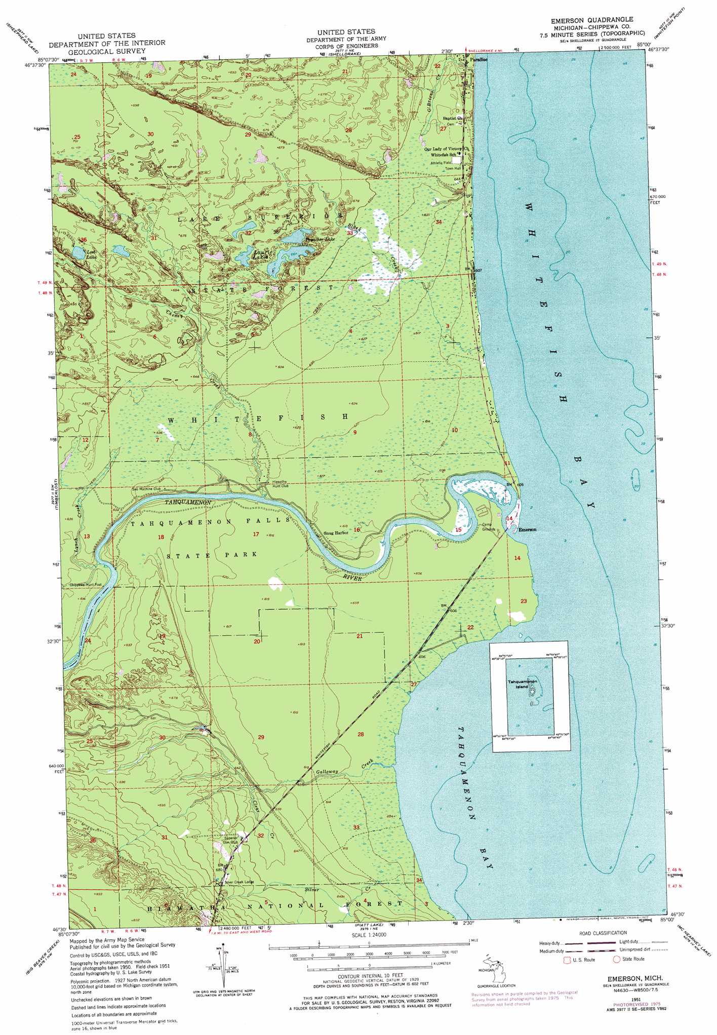
Emerson Topo Map Michigan
To zoom in, hover over the map of Emerson
USGS Topo Quad 46085e1 - 1:24,000 scale
| Topo Map Name: | Emerson |
| USGS Topo Quad ID: | 46085e1 |
| Print Size: | ca. 21 1/4" wide x 27" high |
| Southeast Coordinates: | 46.5° N latitude / 85° W longitude |
| Map Center Coordinates: | 46.5625° N latitude / 85.0625° W longitude |
| U.S. State: | MI |
| Filename: | o46085e1.jpg |
| Download Map JPG Image: | Emerson topo map 1:24,000 scale |
| Map Type: | Topographic |
| Topo Series: | 7.5´ |
| Map Scale: | 1:24,000 |
| Source of Map Images: | United States Geological Survey (USGS) |
| Alternate Map Versions: |
Emerson MI 1951, updated 1955 Download PDF Buy paper map Emerson MI 1951, updated 1977 Download PDF Buy paper map Emerson MI 2011 Download PDF Buy paper map Emerson MI 2014 Download PDF Buy paper map Emerson MI 2017 Download PDF Buy paper map |
| FStopo: | US Forest Service topo Emerson is available: Download FStopo PDF Download FStopo TIF |
1:24,000 Topo Quads surrounding Emerson
Vermilion |
Vermilion Se |
|||
Betsy Lake North |
Sheephead Lake |
Shelldrake |
Whitefish Point |
|
Betsy Lake South |
Timberlost |
Emerson |
||
Gimlet Creek |
Big Beaver Creek |
Piatt Lake |
Mcnearney Lake |
Pendills Lake |
Soo Junction |
Hulbert |
Eckerman |
Strongs |
Sullivan Creek |
> Back to 46085e1 at 1:100,000 scale
> Back to 46084a1 at 1:250,000 scale
> Back to U.S. Topo Maps home
Emerson topo map: Gazetteer
Emerson: Bays
Tahquamenon Bay elevation 184m 603′Emerson: Lakes
Laurie Lakes elevation 203m 666′Lost Lake elevation 209m 685′
Preacher Lake elevation 206m 675′
Emerson: Parks
Emerson Historical Marker elevation 185m 606′Whitefish Township Historical Marker elevation 198m 649′
Emerson: Populated Places
Emerson elevation 184m 603′Snug Harbor elevation 186m 610′
Emerson: Post Offices
Emerson Post Office (historical) elevation 184m 603′Paradise Post Office elevation 190m 623′
Emerson: Streams
Black Creek elevation 184m 603′Cheney Creek elevation 184m 603′
Clear Creek elevation 190m 623′
Galloway Creek elevation 184m 603′
Lynch Creek elevation 184m 603′
O'Briens Creek elevation 189m 620′
Silver Creek elevation 188m 616′
Tahquamenon River elevation 184m 603′
Emerson digital topo map on disk
Buy this Emerson topo map showing relief, roads, GPS coordinates and other geographical features, as a high-resolution digital map file on DVD: