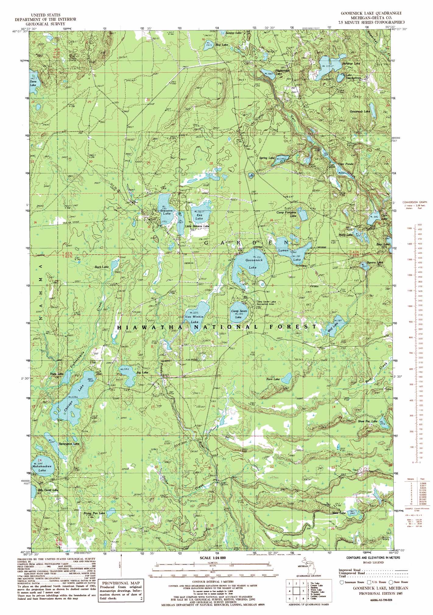
Gooseneck Lake Topo Map Michigan
To zoom in, hover over the map of Gooseneck Lake
USGS Topo Quad 46086a5 - 1:24,000 scale
| Topo Map Name: | Gooseneck Lake |
| USGS Topo Quad ID: | 46086a5 |
| Print Size: | ca. 21 1/4" wide x 27" high |
| Southeast Coordinates: | 46° N latitude / 86.5° W longitude |
| Map Center Coordinates: | 46.0625° N latitude / 86.5625° W longitude |
| U.S. State: | MI |
| Filename: | o46086a5.jpg |
| Download Map JPG Image: | Gooseneck Lake topo map 1:24,000 scale |
| Map Type: | Topographic |
| Topo Series: | 7.5´ |
| Map Scale: | 1:24,000 |
| Source of Map Images: | United States Geological Survey (USGS) |
| Alternate Map Versions: |
Gooseneck Lake MI 1985, updated 1985 Download PDF Buy paper map Gooseneck Lake MI 2011 Download PDF Buy paper map Gooseneck Lake MI 2014 Download PDF Buy paper map Gooseneck Lake MI 2017 Download PDF Buy paper map |
| FStopo: | US Forest Service topo Gooseneck Lake is available: Download FStopo PDF Download FStopo TIF |
1:24,000 Topo Quads surrounding Gooseneck Lake
Forest Lake |
Powell Lake |
Juniper |
Shingleton |
Creighton |
Lake Stella |
The Lake |
Corner Lake |
Steuben |
Steuben Ne |
Poplar Lake |
Waco Lake |
Gooseneck Lake |
Thunder Lake |
Hiawath |
Ensign |
Saint Jacques |
Garden Corners |
Cooks |
Manistique West |
Ogontz |
Nahma |
Gardner |
Hiram Point |
Point Aux Barques |
> Back to 46086a1 at 1:100,000 scale
> Back to 46086a1 at 1:250,000 scale
> Back to U.S. Topo Maps home
Gooseneck Lake topo map: Gazetteer
Gooseneck Lake: Lakes
Back Lake elevation 232m 761′Bog Lake elevation 241m 790′
Camp Fortyone Lake elevation 226m 741′
Camp Seven Lake elevation 230m 754′
Carr Lake elevation 209m 685′
Carr Ponds elevation 214m 702′
Chicago Lake elevation 229m 751′
Eva Lake elevation 235m 770′
Fern Lake elevation 231m 757′
Frying Pan Lake elevation 229m 751′
Ganamush Lake elevation 220m 721′
Gooseneck Lake elevation 231m 757′
Highbridge Lake elevation 231m 757′
Jackpine Lake elevation 225m 738′
Jug Lake elevation 229m 751′
Lake Twentythree elevation 224m 734′
Little Stevens Lake elevation 235m 770′
Lyman Lake elevation 230m 754′
Mahskeekee Lake elevation 229m 751′
Molly Lake elevation 218m 715′
Remington Lake elevation 229m 751′
Shoe Pac Lake elevation 226m 741′
Spring Lake elevation 223m 731′
Square Lake elevation 220m 721′
Stevens Lake elevation 235m 770′
Van Winkle Lake elevation 227m 744′
Vista Lake elevation 226m 741′
West Lake elevation 223m 731′
Wolf Lake elevation 229m 751′
Gooseneck Lake: Parks
Camp Seven Lake Recreation Area elevation 230m 754′Gooseneck Lake: Streams
Onion Creek elevation 219m 718′Gooseneck Lake digital topo map on disk
Buy this Gooseneck Lake topo map showing relief, roads, GPS coordinates and other geographical features, as a high-resolution digital map file on DVD: