Steuben Topo Map Michigan
To zoom in, hover over the map of Steuben
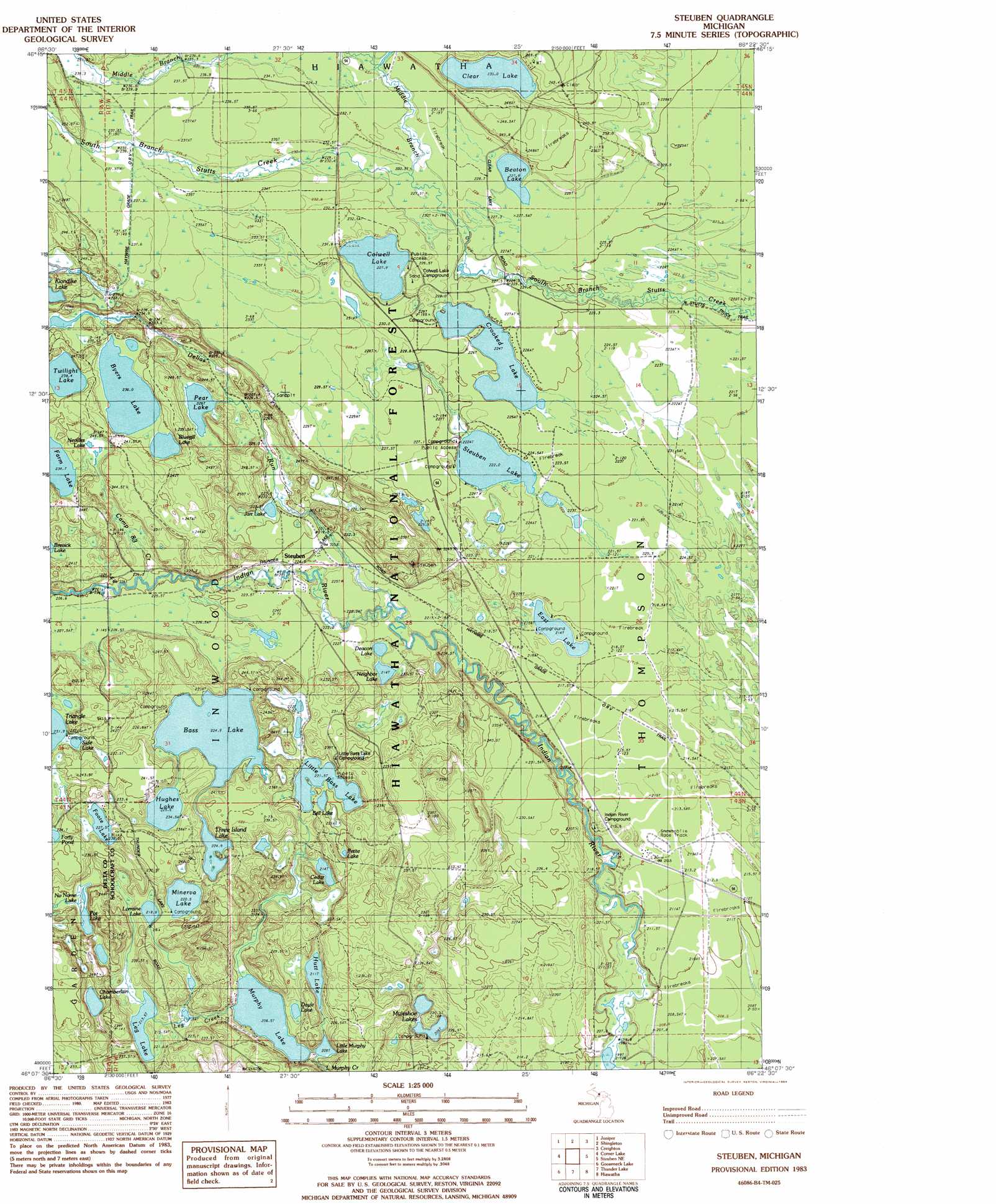
USGS Topo Quad 46086b4 - 1:25,000 scale
| Topo Map Name: | Steuben |
| USGS Topo Quad ID: | 46086b4 |
| Print Size: | ca. 21 1/4" wide x 27" high |
| Southeast Coordinates: | 46.125° N latitude / 86.375° W longitude |
| Map Center Coordinates: | 46.1875° N latitude / 86.4375° W longitude |
| U.S. State: | MI |
| Filename: | l46086b4.jpg |
| Download Map JPG Image: | Steuben topo map 1:25,000 scale |
| Map Type: | Topographic |
| Topo Series: | 7.5´ |
| Map Scale: | 1:25,000 |
| Source of Map Images: | United States Geological Survey (USGS) |
| Alternate Map Versions: | |
| FStopo: | US Forest Service topo Steuben is available: Download FStopo PDF Download FStopo TIF |
1:24,000 Topo Quads surrounding Steuben
Munsing |
Indian Town |
Melstrand |
Cusino |
Driggs Lake |
Powell Lake |
Juniper |
Shingleton |
Creighton |
Walsh |
The Lake |
Corner Lake |
Steuben |
Steuben Ne |
Marsh Creek Pool Nw |
Waco Lake |
Gooseneck Lake |
Thunder Lake |
Hiawath |
Smith Lake |
Saint Jacques |
Garden Corners |
Cooks |
Manistique West |
Manistique East |
> Back to 46086a1 at 1:100,000 scale
> Back to 46086a1 at 1:250,000 scale
> Back to U.S. Topo Maps home
Steuben topo map: Gazetteer
Steuben: Airports
Bass Lake Airport elevation 242m 793′Steuben: Lakes
Bass Lake elevation 223m 731′Beaton Lake elevation 227m 744′
Bell Lake elevation 222m 728′
Bluegill Lake elevation 235m 770′
Byers Lake elevation 235m 770′
Cedar Lake elevation 214m 702′
Chamberlain Lake elevation 217m 711′
Clear Lake elevation 235m 770′
Colwell Lake elevation 228m 748′
Crooked Lake elevation 224m 734′
Deacon Lake elevation 214m 702′
Doyle Lake elevation 212m 695′
East Lake elevation 214m 702′
Foote Lake elevation 225m 738′
Forty Pond elevation 235m 770′
Hughes Lake elevation 226m 741′
Hutt Lake elevation 211m 692′
Jarr Lake elevation 225m 738′
Leg Lake elevation 214m 702′
Little Bass Lake elevation 222m 728′
Little Murphy Lake elevation 209m 685′
Lorraine Lake elevation 218m 715′
Minerva Lake elevation 220m 721′
Muleshoe Lakes elevation 216m 708′
Murphy Lake elevation 207m 679′
Neighbor Lake elevation 215m 705′
Nevilles Lake elevation 232m 761′
No Name Lake elevation 220m 721′
Pear Lake elevation 229m 751′
Petite Lake elevation 224m 734′
Pot Lake elevation 230m 754′
Side Lake elevation 233m 764′
Steuben Lake elevation 222m 728′
Three Island Lake elevation 225m 738′
Twilight Lake elevation 238m 780′
Steuben: Populated Places
Steuben elevation 225m 738′Steuben: Post Offices
Steuben Post Office (historical) elevation 225m 738′Steuben: Streams
Camp Eightthree Creek elevation 221m 725′Delias Run elevation 217m 711′
Leg Creek elevation 207m 679′
Middle Branch Stutts Creek elevation 228m 748′
South Branch Stutts Creek elevation 228m 748′
Steuben: Trails
Haywire Grade ORV Trail elevation 241m 790′Steuben digital topo map on disk
Buy this Steuben topo map showing relief, roads, GPS coordinates and other geographical features, as a high-resolution digital map file on DVD: