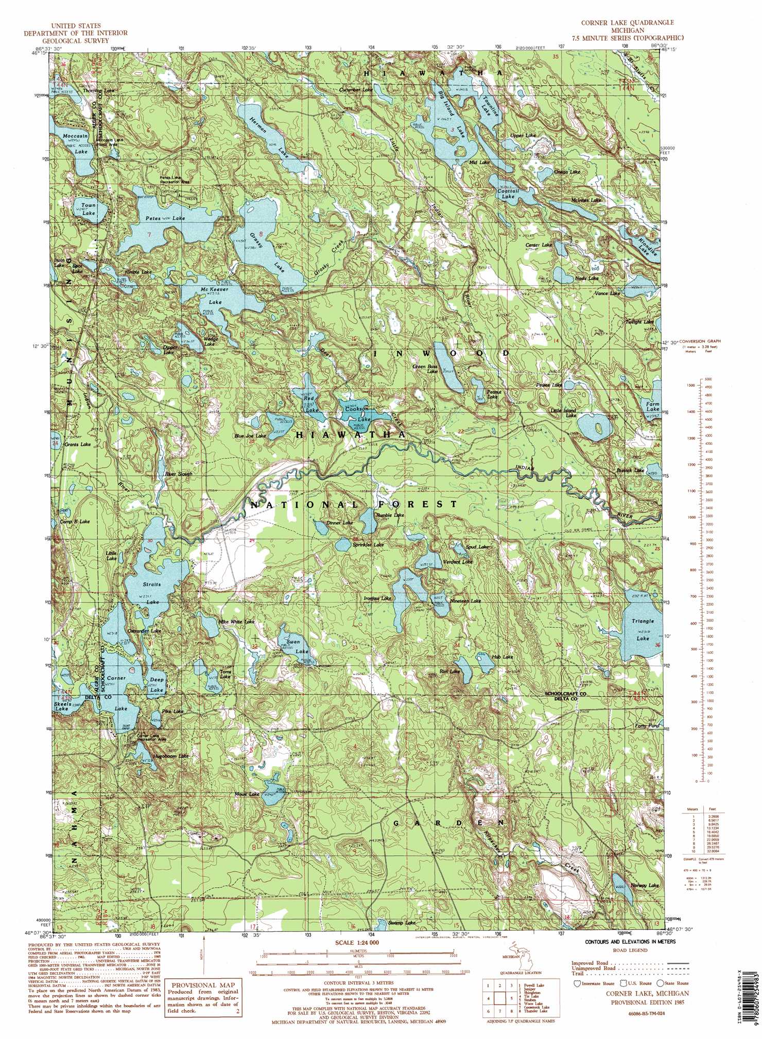
Corner Lake Topo Map Michigan
To zoom in, hover over the map of Corner Lake
USGS Topo Quad 46086b5 - 1:24,000 scale
| Topo Map Name: | Corner Lake |
| USGS Topo Quad ID: | 46086b5 |
| Print Size: | ca. 21 1/4" wide x 27" high |
| Southeast Coordinates: | 46.125° N latitude / 86.5° W longitude |
| Map Center Coordinates: | 46.1875° N latitude / 86.5625° W longitude |
| U.S. State: | MI |
| Filename: | o46086b5.jpg |
| Download Map JPG Image: | Corner Lake topo map 1:24,000 scale |
| Map Type: | Topographic |
| Topo Series: | 7.5´ |
| Map Scale: | 1:24,000 |
| Source of Map Images: | United States Geological Survey (USGS) |
| Alternate Map Versions: |
Corner Lake MI 1985, updated 1985 Download PDF Buy paper map Corner Lake MI 1985, updated 1985 Download PDF Buy paper map Corner Lake MI 2011 Download PDF Buy paper map Corner Lake MI 2014 Download PDF Buy paper map Corner Lake MI 2017 Download PDF Buy paper map |
| FStopo: | US Forest Service topo Corner Lake is available: Download FStopo PDF Download FStopo TIF |
1:24,000 Topo Quads surrounding Corner Lake
Au Train |
Munsing |
Indian Town |
Melstrand |
Cusino |
Forest Lake |
Powell Lake |
Juniper |
Shingleton |
Creighton |
Lake Stella |
The Lake |
Corner Lake |
Steuben |
Steuben Ne |
Poplar Lake |
Waco Lake |
Gooseneck Lake |
Thunder Lake |
Hiawath |
Ensign |
Saint Jacques |
Garden Corners |
Cooks |
Manistique West |
> Back to 46086a1 at 1:100,000 scale
> Back to 46086a1 at 1:250,000 scale
> Back to U.S. Topo Maps home
Corner Lake topo map: Gazetteer
Corner Lake: Airports
Stueben Landing Field elevation 252m 826′Corner Lake: Lakes
Big Island Lake elevation 247m 810′Blue Joe Lake elevation 235m 770′
Brevick Lake elevation 229m 751′
Camp K Lake elevation 241m 790′
Center Lake elevation 238m 780′
Coattail Lake elevation 241m 790′
Cookson Lake elevation 230m 754′
Corner Lake elevation 231m 757′
Cucumber Lake elevation 247m 810′
Deep Lake elevation 231m 757′
Dinner Lake elevation 235m 770′
Dipper Lake elevation 238m 780′
Farm Lake elevation 235m 770′
Grants Lake elevation 240m 787′
Grassy Lake elevation 238m 780′
Green Bass Lake elevation 238m 780′
Herman Lake elevation 246m 807′
Hub Lake elevation 238m 780′
Hugoboom Lake elevation 232m 761′
Ironjaw Lake elevation 235m 770′
Kimble Lake elevation 238m 780′
Klondike Lake elevation 238m 780′
Little Island Lake elevation 232m 761′
Little Lake elevation 233m 764′
McInnes Lake elevation 244m 800′
McKeever Lake elevation 238m 780′
Mid Lake elevation 244m 800′
Mike White Lake elevation 235m 770′
Moccasin Lake elevation 244m 800′
Mowe Lake elevation 241m 790′
Neds Lake elevation 244m 800′
Nineteen Lake elevation 232m 761′
Norway Lake elevation 220m 721′
Onega Lake elevation 244m 800′
Ostrander Lake elevation 232m 761′
Peanut Lake elevation 232m 761′
Petes Lake elevation 241m 790′
Pewee Lake elevation 232m 761′
Pike Lake elevation 232m 761′
Red Lake elevation 232m 761′
Rim Lake elevation 238m 780′
River Slough elevation 232m 761′
Rumble Lake elevation 229m 751′
Skeels Lake elevation 231m 757′
Spot Lake elevation 238m 780′
Sprinkler Lake elevation 235m 770′
Spud Lake elevation 238m 780′
Straits Lake elevation 231m 757′
Swan Lake elevation 238m 780′
Thornton Lake elevation 247m 810′
Toms Lake elevation 235m 770′
Town Lake elevation 240m 787′
Townline Lake elevation 244m 800′
Triangle Lake elevation 232m 761′
Upper Lake elevation 243m 797′
Vance Lake elevation 235m 770′
Verdant Lake elevation 233m 764′
Wedge Lake elevation 237m 777′
Corner Lake: Parks
Corner Lake Recreation Park elevation 239m 784′Corner Lake: Post Offices
Uno Post Office (historical) elevation 241m 790′Corner Lake: Streams
Deer Creek elevation 225m 738′Grassy Creek elevation 237m 777′
Little Indian River elevation 225m 738′
Corner Lake: Trails
Big Island Lake Portage Canoe Trail elevation 245m 803′Corner Lake digital topo map on disk
Buy this Corner Lake topo map showing relief, roads, GPS coordinates and other geographical features, as a high-resolution digital map file on DVD: