Au Train Topo Map Michigan
To zoom in, hover over the map of Au Train
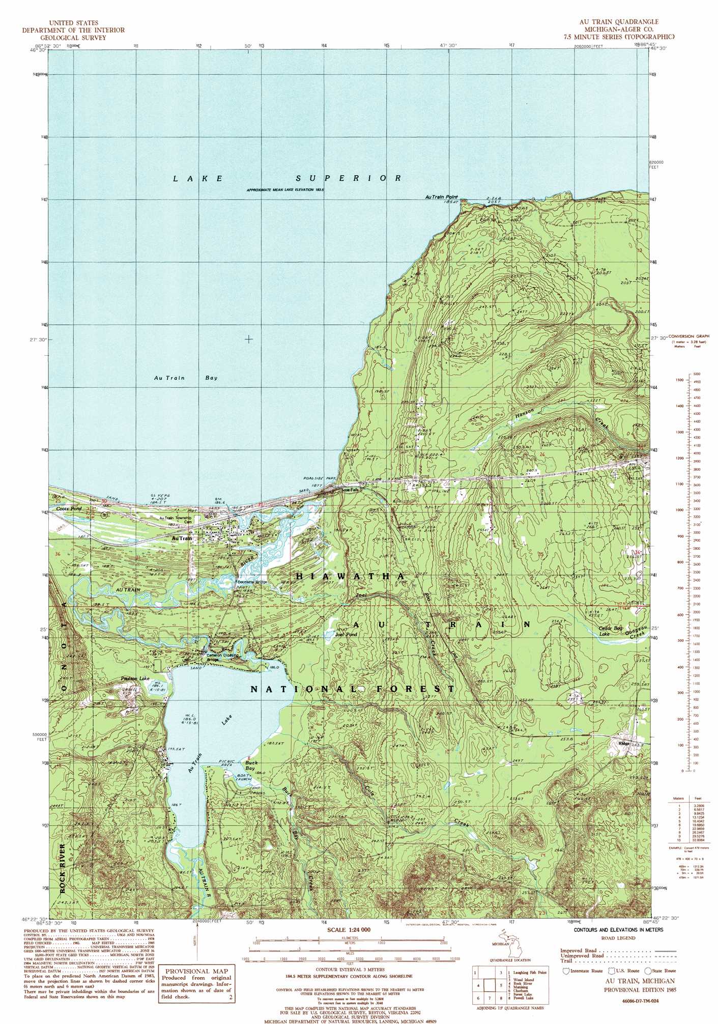
USGS Topo Quad 46086d7 - 1:24,000 scale
| Topo Map Name: | Au Train |
| USGS Topo Quad ID: | 46086d7 |
| Print Size: | ca. 21 1/4" wide x 27" high |
| Southeast Coordinates: | 46.375° N latitude / 86.75° W longitude |
| Map Center Coordinates: | 46.4375° N latitude / 86.8125° W longitude |
| U.S. State: | MI |
| Filename: | o46086d7.jpg |
| Download Map JPG Image: | Au Train topo map 1:24,000 scale |
| Map Type: | Topographic |
| Topo Series: | 7.5´ |
| Map Scale: | 1:24,000 |
| Source of Map Images: | United States Geological Survey (USGS) |
| Alternate Map Versions: |
Au Train MI 1985, updated 1985 Download PDF Buy paper map Au Train MI 2011 Download PDF Buy paper map Au Train MI 2014 Download PDF Buy paper map Au Train MI 2017 Download PDF Buy paper map |
| FStopo: | US Forest Service topo Au Train is available: Download FStopo PDF Download FStopo TIF |
1:24,000 Topo Quads surrounding Au Train
Shot Point |
Laughing Fish Point |
Wood Island |
Wood Island Se |
|
Sand River |
Rock River |
Au Train |
Munsing |
Indian Town |
Ladoga |
Chatham |
Forest Lake |
Powell Lake |
Juniper |
Diffin |
Trenary |
Lake Stella |
The Lake |
Corner Lake |
> Back to 46086a1 at 1:100,000 scale
> Back to 46086a1 at 1:250,000 scale
> Back to U.S. Topo Maps home
Au Train topo map: Gazetteer
Au Train: Bars
Williams Shoal elevation 184m 603′Au Train: Bays
Buck Bay elevation 186m 610′Au Train: Bridges
Cameron Crossing Bridge elevation 186m 610′Doucette Bridge elevation 186m 610′
Au Train: Capes
Au Train Point elevation 189m 620′Au Train: Falls
Cole Creek Falls elevation 198m 649′Scott Falls elevation 196m 643′
Au Train: Lakes
Au Train Lake elevation 186m 610′Cedar Bog Lake elevation 250m 820′
Coots Pond elevation 186m 610′
Joel Pond elevation 191m 626′
Paulson Lake elevation 186m 610′
Au Train: Parks
Lake Superior Historical Marker elevation 192m 629′Paulson House Historical Marker elevation 190m 623′
Scott Falls Roadside Park elevation 192m 629′
Au Train: Populated Places
Au Train elevation 186m 610′Au Train: Post Offices
Au Train Post Office elevation 184m 603′Au Train: Streams
Au Train River elevation 184m 603′Buck Bay Creek elevation 186m 610′
Cole Creek elevation 186m 610′
Joel Creek elevation 184m 603′
Au Train digital topo map on disk
Buy this Au Train topo map showing relief, roads, GPS coordinates and other geographical features, as a high-resolution digital map file on DVD: