Ishpeming Topo Map Michigan
To zoom in, hover over the map of Ishpeming
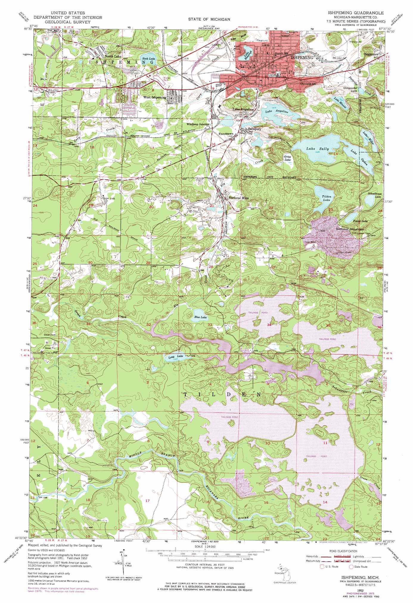
USGS Topo Quad 46087d6 - 1:24,000 scale
| Topo Map Name: | Ishpeming |
| USGS Topo Quad ID: | 46087d6 |
| Print Size: | ca. 21 1/4" wide x 27" high |
| Southeast Coordinates: | 46.375° N latitude / 87.625° W longitude |
| Map Center Coordinates: | 46.4375° N latitude / 87.6875° W longitude |
| U.S. State: | MI |
| Filename: | o46087d6.jpg |
| Download Map JPG Image: | Ishpeming topo map 1:24,000 scale |
| Map Type: | Topographic |
| Topo Series: | 7.5´ |
| Map Scale: | 1:24,000 |
| Source of Map Images: | United States Geological Survey (USGS) |
| Alternate Map Versions: |
Ishpeming MI 1952, updated 1954 Download PDF Buy paper map Ishpeming MI 1952, updated 1958 Download PDF Buy paper map Ishpeming MI 1952, updated 1977 Download PDF Buy paper map Ishpeming MI 2011 Download PDF Buy paper map Ishpeming MI 2014 Download PDF Buy paper map Ishpeming MI 2017 Download PDF Buy paper map |
1:24,000 Topo Quads surrounding Ishpeming
Bulldog Lake |
Silver Lake Basin |
Negaunee Nw |
Buckroe |
Marquette Nw |
Champion |
Diorite |
Negaunee Sw |
Negaunee |
Marquette |
Republic |
Greenwood |
Ishpeming |
Palmer |
Sands |
Republic Sw |
Chabeneau Lake |
Green Hills |
Cataract Basin |
Gwinn |
Ralph Nw |
Ralph Ne |
Northland Nw |
Northland Ne |
Anderson Lake |
> Back to 46087a1 at 1:100,000 scale
> Back to 46086a1 at 1:250,000 scale
> Back to U.S. Topo Maps home
Ishpeming topo map: Gazetteer
Ishpeming: Cliffs
Last Bluff elevation 471m 1545′Ishpeming: Falls
Ely Falls elevation 437m 1433′White City Falls elevation 418m 1371′
Ishpeming: Lakes
Blue Lake elevation 410m 1345′Foster Lake elevation 479m 1571′
Gunpowder Lake elevation 440m 1443′
Lake Angeline elevation 431m 1414′
Lake Bancroft elevation 431m 1414′
Lake Miller elevation 485m 1591′
Lake Minnie elevation 475m 1558′
Lake Ogden elevation 466m 1528′
Long Lake elevation 410m 1345′
Rock Lake elevation 430m 1410′
Schoolhouse Lake elevation 473m 1551′
Tilden Lake elevation 482m 1581′
Ishpeming: Mines
Cliffs Mines elevation 439m 1440′Tilden Mine elevation 447m 1466′
Tilden Mine elevation 492m 1614′
Ishpeming: Parks
Cliffs Shaft Mine Historical Marker elevation 438m 1437′Ishpeming Township Recreation Area elevation 445m 1459′
Lake Angeline Park elevation 431m 1414′
Lake Bancroft Park elevation 436m 1430′
Ishpeming: Populated Places
Frenchtown elevation 442m 1450′Ishpeming elevation 429m 1407′
Lake Angeline elevation 440m 1443′
National Mine elevation 427m 1400′
North Lake elevation 472m 1548′
Salisbury elevation 439m 1440′
West Ishpeming elevation 439m 1440′
Winthrop Junction elevation 438m 1437′
Ishpeming: Post Offices
Ishpeming Post Office elevation 430m 1410′National Mine Post Office (historical) elevation 427m 1400′
Stoneville Post Office (historical) elevation 466m 1528′
Tilden Post Office (historical) elevation 482m 1581′
Ishpeming: Reservoirs
Lake Sally elevation 467m 1532′Ishpeming: Streams
Ely Creek elevation 407m 1335′Green Creek elevation 407m 1335′
Partridge Creek elevation 437m 1433′
Ishpeming: Summits
Pilot Knob elevation 457m 1499′Summit Mountain elevation 571m 1873′
Ishpeming: Swamps
Grass Lake elevation 454m 1489′Ishpeming digital topo map on disk
Buy this Ishpeming topo map showing relief, roads, GPS coordinates and other geographical features, as a high-resolution digital map file on DVD: