Champion Topo Map Michigan
To zoom in, hover over the map of Champion
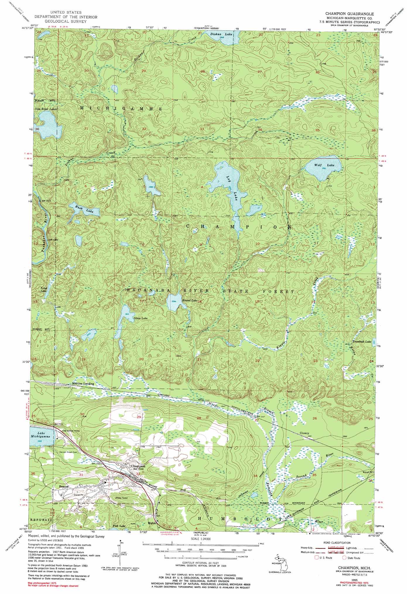
USGS Topo Quad 46087e8 - 1:24,000 scale
| Topo Map Name: | Champion |
| USGS Topo Quad ID: | 46087e8 |
| Print Size: | ca. 21 1/4" wide x 27" high |
| Southeast Coordinates: | 46.5° N latitude / 87.875° W longitude |
| Map Center Coordinates: | 46.5625° N latitude / 87.9375° W longitude |
| U.S. State: | MI |
| Filename: | o46087e8.jpg |
| Download Map JPG Image: | Champion topo map 1:24,000 scale |
| Map Type: | Topographic |
| Topo Series: | 7.5´ |
| Map Scale: | 1:24,000 |
| Source of Map Images: | United States Geological Survey (USGS) |
| Alternate Map Versions: |
Champion MI 1955, updated 1956 Download PDF Buy paper map Champion MI 1955, updated 1970 Download PDF Buy paper map Champion MI 1955, updated 1982 Download PDF Buy paper map Champion MI 2011 Download PDF Buy paper map Champion MI 2014 Download PDF Buy paper map Champion MI 2017 Download PDF Buy paper map |
1:24,000 Topo Quads surrounding Champion
Skanee South |
Mccomb Corner |
Mountain Lake |
Ives Hill |
Big Bay |
Mount Curwood |
Summit Lake |
Bulldog Lake |
Silver Lake Basin |
Negaunee Nw |
Three Lakes |
Michigamme |
Champion |
Diorite |
Negaunee Sw |
Nelson Lake |
Witch Lake Ne |
Republic |
Greenwood |
Ishpeming |
Hickman Lake |
Witch Lake |
Republic Sw |
Chabeneau Lake |
Green Hills |
> Back to 46087e1 at 1:100,000 scale
> Back to 46086a1 at 1:250,000 scale
> Back to U.S. Topo Maps home
Champion topo map: Gazetteer
Champion: Lakes
Bush Lake elevation 497m 1630′Dishno Lake elevation 532m 1745′
Glass Lake elevation 490m 1607′
Log Lake elevation 519m 1702′
Long Lake elevation 507m 1663′
Round Lake elevation 483m 1584′
Van Riper Lakes elevation 508m 1666′
Wolf Lake elevation 521m 1709′
Champion: Parks
Van Riper Park elevation 484m 1587′Champion: Populated Places
Beacon elevation 527m 1729′Champion elevation 485m 1591′
Clowry elevation 472m 1548′
Martins Landing elevation 474m 1555′
Wobic elevation 501m 1643′
Champion: Post Offices
Beacon Post Office (historical) elevation 527m 1729′Champion Post Office elevation 486m 1594′
Clowry Post Office (historical) elevation 472m 1548′
Champion: Streams
Dishno Creek elevation 488m 1601′Halfway Creek elevation 467m 1532′
Kipple Creek elevation 471m 1545′
Second River elevation 468m 1535′
Champion digital topo map on disk
Buy this Champion topo map showing relief, roads, GPS coordinates and other geographical features, as a high-resolution digital map file on DVD: