Echo Lake Topo Map Michigan
To zoom in, hover over the map of Echo Lake
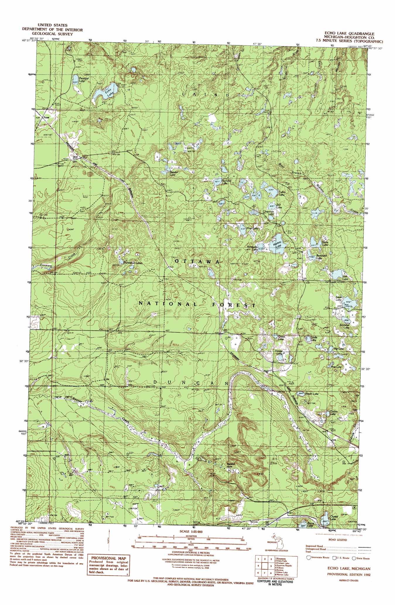
USGS Topo Quad 46088e7 - 1:25,000 scale
| Topo Map Name: | Echo Lake |
| USGS Topo Quad ID: | 46088e7 |
| Print Size: | ca. 21 1/4" wide x 27" high |
| Southeast Coordinates: | 46.5° N latitude / 88.75° W longitude |
| Map Center Coordinates: | 46.5625° N latitude / 88.8125° W longitude |
| U.S. State: | MI |
| Filename: | l46088e7.jpg |
| Download Map JPG Image: | Echo Lake topo map 1:25,000 scale |
| Map Type: | Topographic |
| Topo Series: | 7.5´ |
| Map Scale: | 1:25,000 |
| Source of Map Images: | United States Geological Survey (USGS) |
| Alternate Map Versions: |
Echo Lake MI 1982, updated 1983 Download PDF Buy paper map |
| FStopo: | US Forest Service topo Echo Lake is available: Download FStopo PDF Download FStopo TIF |
1:24,000 Topo Quads surrounding Echo Lake
Greenland |
Winona South |
Nisula |
Pelkie |
Bear Town |
Mckeever |
Rousseau |
Vista Falls |
Prickett Lake |
Baraga Plains |
Paynesville |
Sparrows Rapids |
Echo Lake |
Sidnaw |
Covington |
Trout Creek |
Kenton |
Glitter Lake |
Marten Lake |
Tunis |
Fuller |
Lake Mitigwaki |
Winslow Lake |
Perch Lake |
Porter Lake |
> Back to 46088e1 at 1:100,000 scale
> Back to 46088a1 at 1:250,000 scale
> Back to U.S. Topo Maps home
Echo Lake topo map: Gazetteer
Echo Lake: Lakes
Barchard Lake elevation 416m 1364′Bender Lake elevation 408m 1338′
Booth Lake elevation 394m 1292′
Burns Lake elevation 394m 1292′
Chapman Pond elevation 425m 1394′
Corbin Lake elevation 398m 1305′
Crystal Lake elevation 399m 1309′
Davis Lake elevation 414m 1358′
Dentel Lake elevation 405m 1328′
Echo Lake elevation 422m 1384′
Estes Lake elevation 406m 1332′
Fuller Lake elevation 424m 1391′
Green Lake elevation 403m 1322′
Hop Lake elevation 425m 1394′
Irish Lake elevation 408m 1338′
Kentucky Lake elevation 414m 1358′
Linda Lake elevation 413m 1354′
Markey Lake elevation 413m 1354′
Penegor Lake elevation 433m 1420′
Pine Lake elevation 415m 1361′
Plantation Lakes elevation 392m 1286′
Richard Lake elevation 421m 1381′
Saunder Lake elevation 406m 1332′
Saw Lake elevation 380m 1246′
Skip Lake elevation 404m 1325′
Staff Lake elevation 418m 1371′
Still Lake elevation 429m 1407′
Echo Lake: Populated Places
Frost elevation 427m 1400′Echo Lake: Post Offices
Crystal Lake Post Office (historical) elevation 420m 1377′Echo Lake digital topo map on disk
Buy this Echo Lake topo map showing relief, roads, GPS coordinates and other geographical features, as a high-resolution digital map file on DVD: