Prickett Lake Topo Map Michigan
To zoom in, hover over the map of Prickett Lake
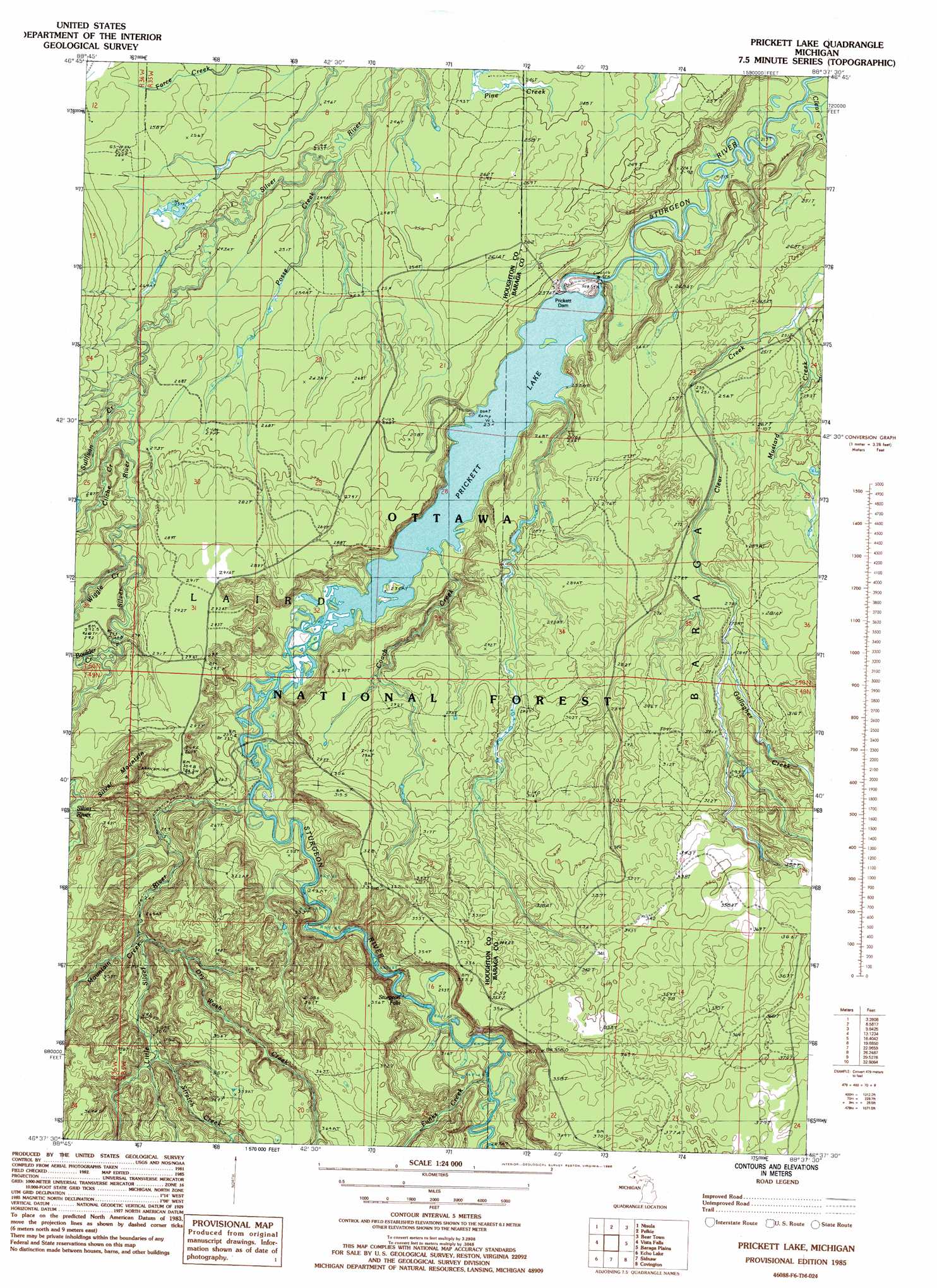
USGS Topo Quad 46088f6 - 1:24,000 scale
| Topo Map Name: | Prickett Lake |
| USGS Topo Quad ID: | 46088f6 |
| Print Size: | ca. 21 1/4" wide x 27" high |
| Southeast Coordinates: | 46.625° N latitude / 88.625° W longitude |
| Map Center Coordinates: | 46.6875° N latitude / 88.6875° W longitude |
| U.S. State: | MI |
| Filename: | o46088f6.jpg |
| Download Map JPG Image: | Prickett Lake topo map 1:24,000 scale |
| Map Type: | Topographic |
| Topo Series: | 7.5´ |
| Map Scale: | 1:24,000 |
| Source of Map Images: | United States Geological Survey (USGS) |
| Alternate Map Versions: |
Prickett Lake MI 1985, updated 1986 Download PDF Buy paper map Prickett Lake MI 1999, updated 2004 Download PDF Buy paper map Prickett Lake MI 2011 Download PDF Buy paper map Prickett Lake MI 2014 Download PDF Buy paper map Prickett Lake MI 2016 Download PDF Buy paper map |
| FStopo: | US Forest Service topo Prickett Lake is available: Download FStopo PDF Download FStopo TIF |
1:24,000 Topo Quads surrounding Prickett Lake
Winona North |
Donken |
Pine Lake |
Otter Lake |
Portage Entry |
Winona South |
Nisula |
Pelkie |
Bear Town |
L'Anse |
Rousseau |
Vista Falls |
Prickett Lake |
Baraga Plains |
Alberta |
Sparrows Rapids |
Echo Lake |
Sidnaw |
Covington |
Vermilac |
Kenton |
Glitter Lake |
Marten Lake |
Tunis |
Drummond Lake |
> Back to 46088e1 at 1:100,000 scale
> Back to 46088a1 at 1:250,000 scale
> Back to U.S. Topo Maps home
Prickett Lake topo map: Gazetteer
Prickett Lake: Dams
Pickett Dam elevation 230m 754′Prickett Lake: Falls
Sturgeon Falls elevation 268m 879′Prickett Lake: Reservoirs
Prickett Lake elevation 234m 767′Prickett Lake: Streams
Boulder Creek elevation 271m 889′Clear Creek elevation 213m 698′
Cliche Creek elevation 257m 843′
Coach Creek elevation 232m 761′
Dry Wash Creek elevation 269m 882′
Funks Creek elevation 293m 961′
Gallagher Creek elevation 279m 915′
Hershley Creek elevation 251m 823′
Little Silver River elevation 239m 784′
Mountain Creek elevation 274m 898′
Mustard Creek elevation 246m 807′
Posse Creek elevation 233m 764′
Stretch Creek elevation 304m 997′
Sullivan Creek elevation 251m 823′
Wiggle Creek elevation 266m 872′
Prickett Lake: Summits
Silver Mount elevation 398m 1305′Prickett Lake: Trails
Pelkie Creek Hunter Walking Trails elevation 250m 820′Prickett Lake digital topo map on disk
Buy this Prickett Lake topo map showing relief, roads, GPS coordinates and other geographical features, as a high-resolution digital map file on DVD: