Rousseau Topo Map Michigan
To zoom in, hover over the map of Rousseau
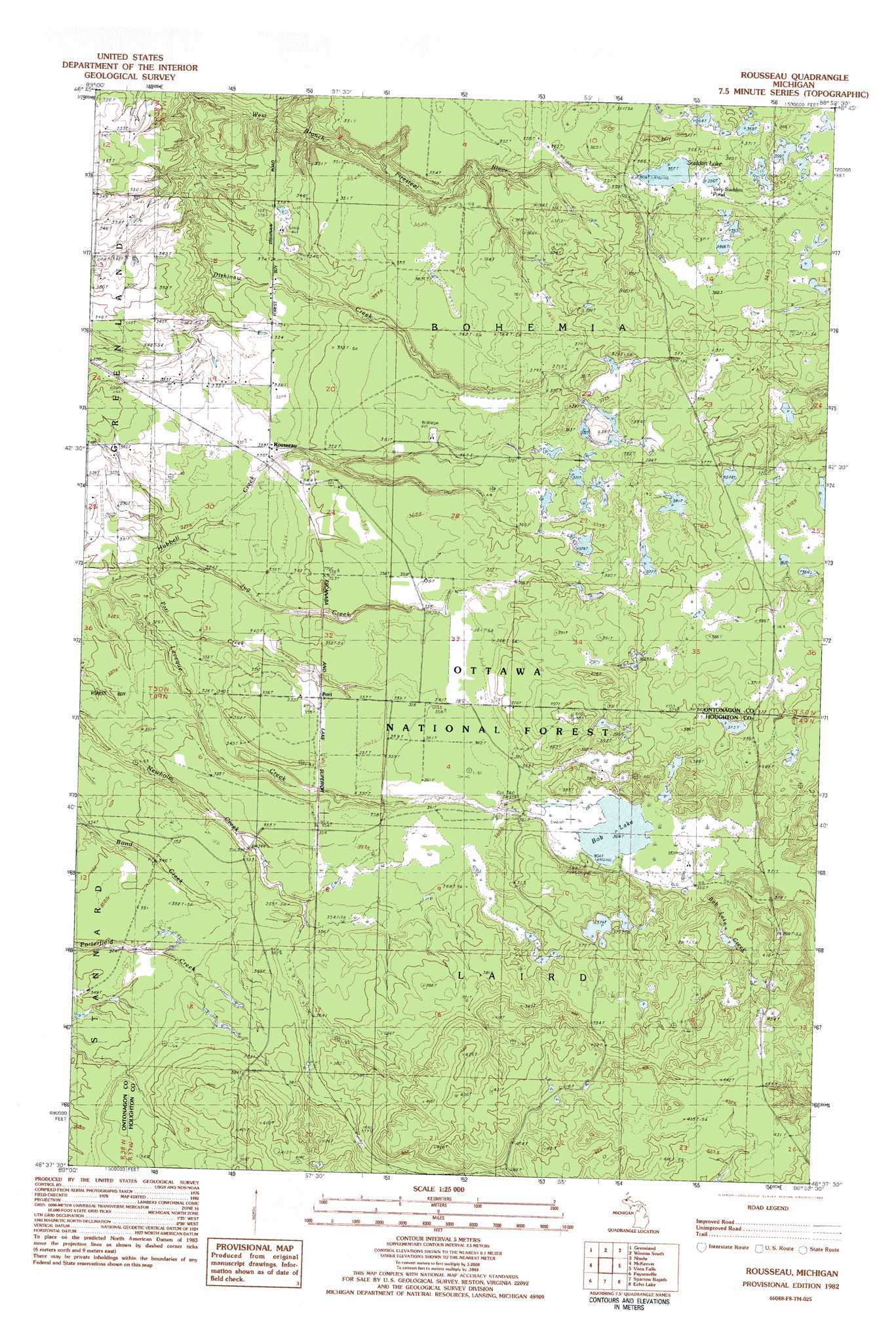
USGS Topo Quad 46088f8 - 1:25,000 scale
| Topo Map Name: | Rousseau |
| USGS Topo Quad ID: | 46088f8 |
| Print Size: | ca. 21 1/4" wide x 27" high |
| Southeast Coordinates: | 46.625° N latitude / 88.875° W longitude |
| Map Center Coordinates: | 46.6875° N latitude / 88.9375° W longitude |
| U.S. State: | MI |
| Filename: | l46088f8.jpg |
| Download Map JPG Image: | Rousseau topo map 1:25,000 scale |
| Map Type: | Topographic |
| Topo Series: | 7.5´ |
| Map Scale: | 1:25,000 |
| Source of Map Images: | United States Geological Survey (USGS) |
| Alternate Map Versions: |
Rousseau MI 1982, updated 1983 Download PDF Buy paper map |
| FStopo: | US Forest Service topo Rousseau is available: Download FStopo PDF Download FStopo TIF |
1:24,000 Topo Quads surrounding Rousseau
Tenmile Point |
Four Corners |
Winona North |
Donken |
Pine Lake |
Firesteel |
Greenland |
Winona South |
Nisula |
Pelkie |
Rockland |
Mckeever |
Rousseau |
Vista Falls |
Prickett Lake |
Bruce Crossing |
Paynesville |
Sparrows Rapids |
Echo Lake |
Sidnaw |
Paulding |
Trout Creek |
Kenton |
Glitter Lake |
Marten Lake |
> Back to 46088e1 at 1:100,000 scale
> Back to 46088a1 at 1:250,000 scale
> Back to U.S. Topo Maps home
Rousseau topo map: Gazetteer
Rousseau: Airports
Nikkila Farms Airport elevation 331m 1085′Rousseau: Lakes
Bob Lake elevation 364m 1194′Sudden Lake elevation 357m 1171′
Very Sudden Pond elevation 356m 1167′
Rousseau: Populated Places
Pori elevation 354m 1161′Rousseau elevation 338m 1108′
Rousseau: Post Offices
New Home Post Office (historical) elevation 374m 1227′Plato Post Office (historical) elevation 354m 1161′
Rousseau Post Office (historical) elevation 338m 1108′
Rousseau: Streams
Bob Lake Creek elevation 365m 1197′Dishinaw Creek elevation 296m 971′
Jug Creek elevation 315m 1033′
Leveque Creek elevation 308m 1010′
Pori Creek elevation 312m 1023′
Rousseau digital topo map on disk
Buy this Rousseau topo map showing relief, roads, GPS coordinates and other geographical features, as a high-resolution digital map file on DVD: