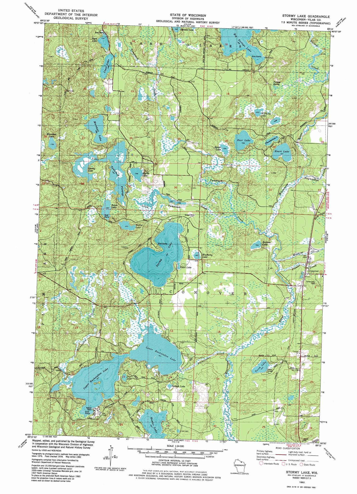
Stormy Lake Topo Map Wisconsin
To zoom in, hover over the map of Stormy Lake
USGS Topo Quad 46089a3 - 1:24,000 scale
| Topo Map Name: | Stormy Lake |
| USGS Topo Quad ID: | 46089a3 |
| Print Size: | ca. 21 1/4" wide x 27" high |
| Southeast Coordinates: | 46° N latitude / 89.25° W longitude |
| Map Center Coordinates: | 46.0625° N latitude / 89.3125° W longitude |
| U.S. State: | WI |
| Filename: | o46089a3.jpg |
| Download Map JPG Image: | Stormy Lake topo map 1:24,000 scale |
| Map Type: | Topographic |
| Topo Series: | 7.5´ |
| Map Scale: | 1:24,000 |
| Source of Map Images: | United States Geological Survey (USGS) |
| Alternate Map Versions: |
Stormy Lake WI 1982, updated 1982 Download PDF Buy paper map Stormy Lake WI 2010 Download PDF Buy paper map Stormy Lake WI 2013 Download PDF Buy paper map Stormy Lake WI 2015 Download PDF Buy paper map |
1:24,000 Topo Quads surrounding Stormy Lake
Gogebic |
Thayer |
Beaton |
Watersmeet |
Fuller |
Tenderfoot Lake |
Thousand Island Lake |
Black Oak Lake |
Land O' Lakes |
Imp Lake |
White Sand Lake |
Star Lake |
Stormy Lake |
Pioneer Lake |
Phelps |
Sayner |
Saint Germain |
Eagle River West |
Eagle River East |
Anvil Lake |
Lake Tomahawk |
Dam Lake |
Sugar Camp |
Three Lakes |
Julia Lake |
> Back to 46089a1 at 1:100,000 scale
> Back to 46088a1 at 1:250,000 scale
> Back to U.S. Topo Maps home
Stormy Lake topo map: Gazetteer
Stormy Lake: Dams
Buckatahpon 1909c361 Dam elevation 502m 1646′Little Tamarack Creek 2WP882 Dam elevation 506m 1660′
Stormy Lake: Islands
Colin Island elevation 503m 1650′Stormy Lake: Lakes
Baker Lake elevation 508m 1666′Bennett Lake elevation 504m 1653′
Big Portage Lake elevation 514m 1686′
Blueberry Lake elevation 509m 1669′
Chamberlain Lake elevation 507m 1663′
Clair Lake elevation 519m 1702′
Deer Lake elevation 508m 1666′
Heart Lake elevation 505m 1656′
Hunter Lake elevation 502m 1646′
Joyce Lake elevation 520m 1706′
Little Tamarack Flowage elevation 508m 1666′
Lower Buckatabon Lake elevation 500m 1640′
Marshall Lake elevation 515m 1689′
Monahan Lake elevation 525m 1722′
Myrtle Lake elevation 508m 1666′
Nudist Lake elevation 510m 1673′
Pearl Lake elevation 507m 1663′
Pollack Lake elevation 502m 1646′
Reiter Lake elevation 506m 1660′
Soleit Lake elevation 500m 1640′
Spring Lake elevation 508m 1666′
Stormy Lake elevation 506m 1660′
Torch Lake elevation 504m 1653′
Upper Buckatabon Lake elevation 501m 1643′
Williams Lake elevation 510m 1673′
Stormy Lake: Parks
Community Park elevation 509m 1669′Stormy Lake: Populated Places
Conover elevation 504m 1653′Stormy Lake: Reservoirs
10 Reservoir elevation 506m 1660′Upper and Lower Buckatabon 14 Rerservoir elevation 501m 1643′
Stormy Lake: Springs
Portage Spring elevation 508m 1666′Stormy Lake: Streams
Buckatabon Creek elevation 503m 1650′Haymeadow Creek elevation 502m 1646′
Little Tamarack Creek elevation 502m 1646′
Muskrat Creek elevation 506m 1660′
Pioneer Creek elevation 502m 1646′
Tamarack Creek elevation 503m 1650′
Stormy Lake digital topo map on disk
Buy this Stormy Lake topo map showing relief, roads, GPS coordinates and other geographical features, as a high-resolution digital map file on DVD: