Gogebic Topo Map Michigan
To zoom in, hover over the map of Gogebic
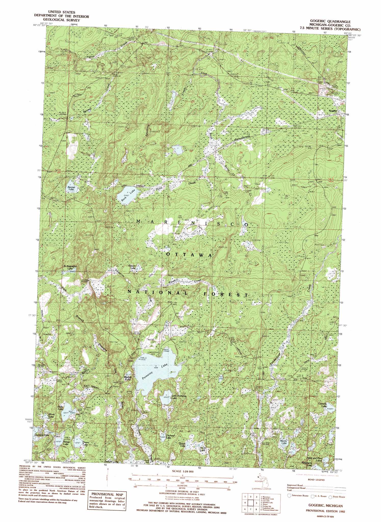
USGS Topo Quad 46089c5 - 1:24,000 scale
| Topo Map Name: | Gogebic |
| USGS Topo Quad ID: | 46089c5 |
| Print Size: | ca. 21 1/4" wide x 27" high |
| Southeast Coordinates: | 46.25° N latitude / 89.5° W longitude |
| Map Center Coordinates: | 46.3125° N latitude / 89.5625° W longitude |
| U.S. State: | MI |
| Filename: | o46089c5.jpg |
| Download Map JPG Image: | Gogebic topo map 1:24,000 scale |
| Map Type: | Topographic |
| Topo Series: | 7.5´ |
| Map Scale: | 1:24,000 |
| Source of Map Images: | United States Geological Survey (USGS) |
| Alternate Map Versions: |
Gogebic MI 1982, updated 1983 Download PDF Buy paper map Gogebic MI 1999, updated 2004 Download PDF Buy paper map Gogebic MI 2011 Download PDF Buy paper map Gogebic MI 2014 Download PDF Buy paper map Gogebic MI 2017 Download PDF Buy paper map |
| FStopo: | US Forest Service topo Gogebic is available: Download FStopo PDF Download FStopo TIF |
1:24,000 Topo Quads surrounding Gogebic
Tula |
Merriweather |
Bergland |
Matchwood |
Ewen |
Wakefield Ne |
Marenisco |
Marshall Creek |
Cup Lake |
Choate |
Harris Lake |
Stateline Lake |
Gogebic |
Thayer |
Beaton |
Papoose Lake |
Presque Isle |
Tenderfoot Lake |
Thousand Island Lake |
Black Oak Lake |
Manitowish Lake |
Boulder Junction |
White Sand Lake |
Star Lake |
Stormy Lake |
> Back to 46089a1 at 1:100,000 scale
> Back to 46088a1 at 1:250,000 scale
> Back to U.S. Topo Maps home
Gogebic topo map: Gazetteer
Gogebic: Lakes
Banner Lake elevation 475m 1558′Barb Lake elevation 471m 1545′
Bluegill Pond elevation 508m 1666′
Cornelia Lake elevation 516m 1692′
Dawn Lake elevation 511m 1676′
Down Lake elevation 511m 1676′
Holly Lake elevation 505m 1656′
Honk Lake elevation 511m 1676′
Little Pomeroy Lake elevation 503m 1650′
Monk Lake elevation 519m 1702′
Morris Lake elevation 506m 1660′
Orchard Lake elevation 513m 1683′
Peter and Paul Lakes elevation 516m 1692′
Pomeroy Lake elevation 496m 1627′
Quack Lake elevation 510m 1673′
Range Lake elevation 512m 1679′
Saint Augustine Lake elevation 483m 1584′
Spruce Lake elevation 487m 1597′
Gogebic: Parks
State River Park elevation 444m 1456′Gogebic: Populated Places
Gogebic elevation 467m 1532′Gogebic: Post Offices
Gogebic Post Office (historical) elevation 467m 1532′Gogebic Post Office (historical) elevation 467m 1532′
Gogebic: Streams
Banner Creek elevation 448m 1469′Bluebill Creek elevation 490m 1607′
Gypo Creek elevation 462m 1515′
Holly Creek elevation 486m 1594′
Orchard Creek elevation 497m 1630′
Pomeroy Creek elevation 478m 1568′
Santa Fe Creek elevation 459m 1505′
Sparkling Creek elevation 448m 1469′
Gogebic digital topo map on disk
Buy this Gogebic topo map showing relief, roads, GPS coordinates and other geographical features, as a high-resolution digital map file on DVD: