Tula Topo Map Michigan
To zoom in, hover over the map of Tula
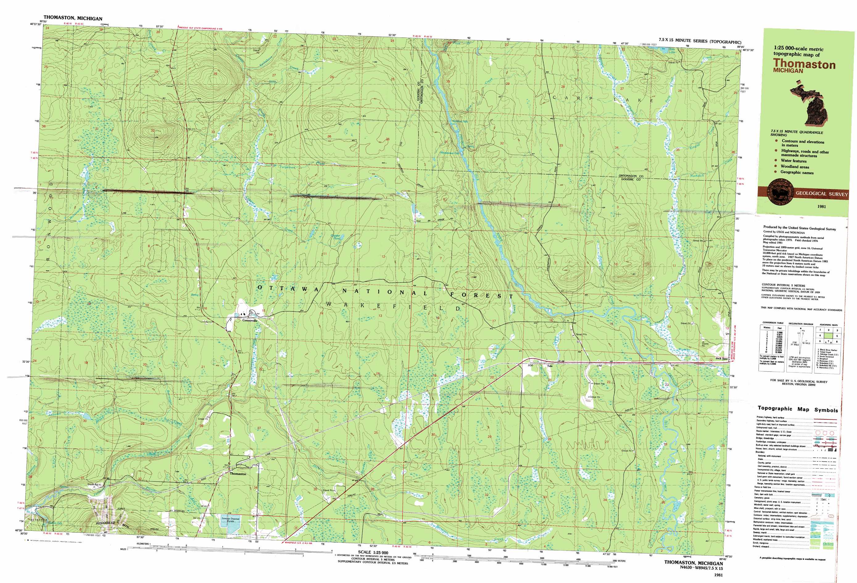
USGS Topo Quad 46089e7 - 1:25,000 scale
| Topo Map Name: | Tula |
| USGS Topo Quad ID: | 46089e7 |
| Print Size: | ca. 39" wide x 24" high |
| Southeast Coordinates: | 46.5° N latitude / 89.75° W longitude |
| Map Center Coordinates: | 46.5625° N latitude / 89.875° W longitude |
| U.S. State: | MI |
| Filename: | k46089e7.jpg |
| Download Map JPG Image: | Tula topo map 1:25,000 scale |
| Map Type: | Topographic |
| Topo Series: | 7.5´x15´ |
| Map Scale: | 1:25,000 |
| Source of Map Images: | United States Geological Survey (USGS) |
| Alternate Map Versions: |
Thomaston MI 1981, updated 1981 Download PDF Buy paper map |
| FStopo: | US Forest Service topo Tula is available: Download FStopo PDF Download FStopo TIF |
1:24,000 Topo Quads surrounding Tula
Carp River East |
Government Peak |
White Pine |
||
Black River Harbor |
Underwood Hill |
Aldridge Creek |
Bergland Ne |
|
Copper Peak |
Tula |
Merriweather |
Bergland |
|
Bessemer |
Wakefield |
Wakefield Ne |
Marenisco |
Marshall Creek |
Lake Evelyn |
Chaney Lake |
Harris Lake |
Stateline Lake |
Gogebic |
> Back to 46089e1 at 1:100,000 scale
> Back to 46088a1 at 1:250,000 scale
> Back to U.S. Topo Maps home
Tula topo map: Gazetteer
Tula: Falls
Gabbro Falls elevation 380m 1246′Minnewawa Falls elevation 375m 1230′
Nimikon Falls elevation 363m 1190′
Root Beer Falls elevation 406m 1332′
Tula: Lakes
Copper Pond elevation 421m 1381′Tula: Populated Places
Connorville elevation 406m 1332′Planter elevation 379m 1243′
Thomaston elevation 413m 1354′
Tula elevation 407m 1335′
Tula: Post Offices
Duke Post Office (historical) elevation 404m 1325′Kilton Post Office (historical) elevation 400m 1312′
Thomaston Post Office (historical) elevation 412m 1351′
Tula Post Office (historical) elevation 407m 1335′
Tula Post Office (historical) elevation 407m 1335′
Tula: Streams
Berranger Creek elevation 374m 1227′Bowden Creek elevation 400m 1312′
Cherry Creek elevation 399m 1309′
Connor Creek elevation 381m 1250′
Crosscut Creek elevation 395m 1295′
Finnegan Creek elevation 405m 1328′
Jackson Creek elevation 363m 1190′
Kinglet Creek elevation 403m 1322′
Nuthatch Creek elevation 402m 1318′
Planter Creek elevation 371m 1217′
Pony Trail Creek elevation 404m 1325′
Salt Pork Creek elevation 357m 1171′
Schroeder Creek elevation 391m 1282′
Spikehorn Creek elevation 363m 1190′
Stag Creek elevation 365m 1197′
Sugar Camp Creek elevation 356m 1167′
Titmouse Creek elevation 407m 1335′
Tula Creek elevation 395m 1295′
Turpeinen Creek elevation 373m 1223′
Vine Creek elevation 362m 1187′
Warbler Creek elevation 398m 1305′
Tula: Trails
Agogebic Ski Trail elevation 445m 1459′Broad Ax Ski Trail elevation 408m 1338′
Chippewa Ski Trail elevation 432m 1417′
Crazy Horse Ski Trail elevation 431m 1414′
Crosscut Ski Trail elevation 388m 1272′
Deer Track Ski Trail elevation 428m 1404′
FIS Racing Ski Trail elevation 432m 1417′
Geronimo Ski Trail elevation 429m 1407′
Gig Ski Trail elevation 386m 1266′
Grizzly Ski Trail elevation 435m 1427′
Hiawatha Ski Trail elevation 446m 1463′
Jacks Cutoff Ski Trail elevation 430m 1410′
Leelinaw Ski Trail elevation 432m 1417′
Narrow Gauge Ski Trail elevation 400m 1312′
Nastar Ski Trail elevation 404m 1325′
Nokomis Ski Trail elevation 432m 1417′
Old Flambeau Ski Trail elevation 433m 1420′
Ox Bow Ski Trail elevation 395m 1295′
River Drive Ski Trail elevation 411m 1348′
Running Bear Ski Trail elevation 430m 1410′
Shanty Boy Ski Trail elevation 405m 1328′
Shanty Girl Ski Trail elevation 402m 1318′
Sundance Ski Trail elevation 432m 1417′
Thornapple Ski Trail elevation 390m 1279′
Tomahawk Ski Trail elevation 429m 1407′
Voyagers Highway Ski Trail elevation 433m 1420′
Winnebago Ski Trail elevation 426m 1397′
Tula digital topo map on disk
Buy this Tula topo map showing relief, roads, GPS coordinates and other geographical features, as a high-resolution digital map file on DVD: